
16.8
PDI
4.9 mi
DISTANCE
2,239 ft
GAINED
8.7 %
AVG. GRADE
FULL CLIMB STATS
INTRO
From Tejedo the Puerto de Ancares looks harmless for a couple of kilometers. The road leaves the village along the valley floor at about 3%, and you could be forgiven for thinking the pass saves its reputation for the Galician sides. Then, about 2.5 km in, it turns up the head of the valley and doesn't let go: the last 5.4 km average about 11.5%, and the final kilometer is as steep as anything before it, at 13%.
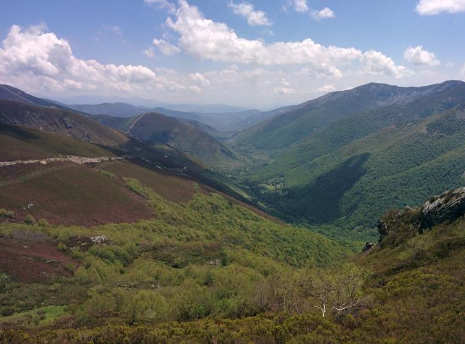
In all it's 7.9 km (4.9 mi) from 951 m (3120 ft) to 1633 m (5358 ft), gaining 682 m (2239 ft) at 8.7%. The upper road is a well-surfaced mountain road with low stone walls, cut through slopes of heather that turn purple in late summer, and the view back down the Valle de Ancares gets bigger with every bend.
The Vuelta a España came down this side in 2011, after crossing the pass from Balouta, and the Vuelta a León finished its queen stage at the top from Candín in 2017. Most riders know the Ancares from the 2014 duel between Alberto Contador and Chris Froome on the Pan do Zarco road; this is the quieter León way up, short and steep at the finish.
PLAN YOUR ROUTE
 We've partnered with Sherpa-Map.com to bring you the best route planning tool. With a PRO Membership you can use this climb as a reference when creating your route.
This side of the Puerto de Ancares climbs 682 m (2239 ft) in 7.9 km (4.9 mi), an 8.7% average, from 951 m (3120 ft) at Tejedo de Ancares to 1633 m (5358 ft) at the pass.
The first 2.5 km (1.6 mi) are a gentle 3%. From there the climb is relentless: the final 5.4 km (3.4 mi) average about 11.5%, and from km 3 every 500 m split sits between 10.7% and 13.1%, with no flat section to recover on. The last kilometer is one of the steepest, at about 13%.
The steepest 0.5 km (0.3 mi) averages 13.2%, the steepest kilometer 13.0%, the steepest 2 km (1.2 mi) 12.2% and the steepest 5 km (3.1 mi) 11.7%. Race previews mention short ramps of about 17%. Use the easy opening to warm up, not to chase time.
Roadway: Paved throughout - the valley road from Vega de Espinareda continues all the way over the pass - with reasonable asphalt on the steep section and low stone walls along the edge. At this height the pass gets snow and thick fog, and heavy snowfall closes it in winter, so check conditions before riding outside summer.
Traffic: Light. Beyond Tejedo the road serves only the pass and the villages on the far side, so most of what you'll meet is visitors heading for the pass and its walking trails.
Parking: Park in Tejedo de Ancares, where the climb begins (start on Google Maps), keeping clear of village lanes and farm access. Pereda de Ancares and Candín, just down the valley, work too if you want a few warm-up kilometers before the start.
Gear: Five kilometers averaging close to 12% call for a compact with at least a 32-tooth cog, and a 34 is no luxury if you're carrying any weight. Save something for the last kilometer - it doesn't ease off.
Provisions: El Rincón del Cuco in Tejedo has a bar-café and Hotel Rural Valle de Ancares in Pereda has a restaurant, but there's nothing at the pass. Clouds rolling in from Galicia pile up against this ridge, so carry a windproof even if it's warm in the valley.
Before heading out on any cycling adventure check out our Things to Bring on a Cycling Trip and use our interactive check list to ensure you don't forget anything.
The Valle de Ancares is worth a couple of nights. In Tejedo, El Rincón del Cuco is a small rural hotel with a bar-café, and in Pereda de Ancares, a few minutes down the valley, Hotel Rural Valle de Ancares has a restaurant and rents bikes. Vega de Espinareda, further down, is the nearest town with a proper range of shops.
Tejedo was an iron-working village. Its water-powered forge was founded in 1788, later fell into ruin, and has been restored by the Candín council - water wheel, hammer and bellows included. In Candín, a path through oak woods leads to the Fumeixín waterfall, an easy rest-day walk, and the Ermita de la Magdalena, Tejedo's patron chapel a few kilometers from the pass, holds a big romería every year.
At the top, the walks to Pico Miravalles and Pico Cuiña and the Balouta viewpoint start right at the pass - our Puerto de Ancares (Murias) page has the details - and our Pan do Zarco page covers the road Contador and Froome raced up in 2014. Sunshine in Tejedo says little about the pass, where cloud from Galicia can sit all day - our Weather tool gives the forecast for the top itself.
ROUTE MAP

MEMBER RATING
CURRENT WEATHER
PJAMM TRIPS ADVENTURE STARTER BUNDLES
Check out PJAMM Adventure's prepackaged (self-guided) cycling trips. They will help you plan, document and conquer your next adventure.
NEARBY CLIMBS (0) RADIAL PROXIMITY
FROM No Climbs Found
MEMBER REVIEWS & COMMENTS
Let us know what you thought of this climb. Signup for our FREE membership to write a review or post a comment.
Already have an account?
LOG IN HERE
