
25.6
PDI
24.2 mi
DISTANCE
5,862 ft
GAINED
3.5 %
AVG. GRADE
FULL CLIMB STATS
INTRO
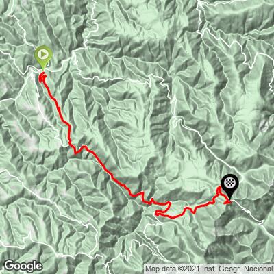
Puerto de Ancares climbs 38.9 km (24.2 mi) from Navia de Suarna, in Galicia's Lugo province, gaining 1,787 m (5,862 ft) to the pass at 1,664 m (5,461 ft). This isn't a steady, uniform grade - the route follows the Rao valley for a long, gently rolling stretch with real descents mixed in before the road steepens noticeably for its final push to the summit, so the 3.5% average hides a much harder finish.
The pass sits on the Lugo-León provincial border and first appeared in the Vuelta a España in 2011, when the race climbed this same Navia de Suarna side - through Murias de Rao and Balouta - on the way from Sarria to a finish in Ponferrada; Juanjo Cobo attacked on the pass and Dani Moreno led over the top. It's a different, longer approach than the steeper Pan do Zarco side used by the Vuelta in 2014, which has its own separate PJAMM page.
The name "Puerto de Ancares" is documented as far back as the 6th century, in the records of a church council held in 572. More recently, Navia de Suarna itself was a filming location for Oliver Laxe's "Fire Will Come" ("O que arde"), which won a jury prize at Cannes in 2019 and premiered in the village's own town square.
PLAN YOUR ROUTE
 We've partnered with Sherpa-Map.com to bring you the best route planning tool. With a PRO Membership you can use this climb as a reference when creating your route.
 Puerto de Ancares gains 1,787 m (5,862 ft) over 38.9 km (24.2 mi) at a 3.5% average grade, finishing at 1,664 m (5,461 ft). That average is misleading - the route includes roughly 442 m (1,451 ft) of net descending along the way, so long rolling sections in the Rao valley cancel out a lot of the early elevation gain. The steepest kilometer averages 12.3% and the steepest mile 11.4%, both concentrated in the final climb to the pass after the valley miles are behind you.
Roadway: The road is paved the entire way, following the LU-722 and LE-4211 through the Rao valley before the final switchbacked climb to the pass. Like other roads through the Serra dos Ancares, it closes with significant snowfall - a February 2026 storm shut the León-side approach to the pass completely, and closures are a normal part of winter here, typically clearing by spring.
Traffic: Light. This is a remote, sparsely populated valley with little through-traffic beyond local residents - expect a quiet ride except during peak summer tourist weekends.
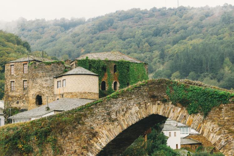
Parking: Free parking is available in Navia de Suarna near the medieval Puente de Navia bridge, close to where the climb begins. There are no dedicated parking areas along the long valley approach, so plan to start from the village.
This is a long day out - 38.9 km (24.2 mi) one way - so pack enough water and food for a full ride, since services are sparse once you leave Navia de Suarna. The road is fully paved, so a standard road bike works, but gear low enough to handle the steep final kilometers to the pass after the long, deceptively gentle valley approach. Temperatures drop well below the valley floor at 1,664 m (5,461 ft), and this pass sees real winter snow, so bring a warm layer for the descent even on a mild day.
Before heading out on any cycling adventure check out our Things to Bring on a Cycling Trip and use our interactive check list to ensure you don't forget anything.
Navia de Suarna is worth a slow look before you start - the medieval Puente de Navia bridge over the Navia river dates back to the 15th century (with Romanesque origins reaching further back), and the village itself was a filming location for Oliver Laxe's Cannes-winning "Fire Will Come," which premiered right in the town square in 2019.
The wider Serra dos Ancares is a UNESCO Biosphere Reserve known for pallozas, circular stone-and-thatch huts that housed people and livestock together into the 1970s - the village of Piornedo, near the steeper Pan do Zarco approach to this same pass, is the best-known place to see them still standing. See other climbs to this pass, including that steeper alternate side, with our Routes in the Area tool.
ROUTE MAP
MEMBER RATING
CURRENT WEATHER
PJAMM TRIPS ADVENTURE STARTER BUNDLES
Check out PJAMM Adventure's prepackaged (self-guided) cycling trips. They will help you plan, document and conquer your next adventure.
NEARBY CLIMBS (0) RADIAL PROXIMITY
FROM No Climbs Found
MEMBER REVIEWS & COMMENTS
Let us know what you thought of this climb. Signup for our FREE membership to write a review or post a comment.
Already have an account?
LOG IN HERE
