![]()
Cycling Sustenpass from Wassen
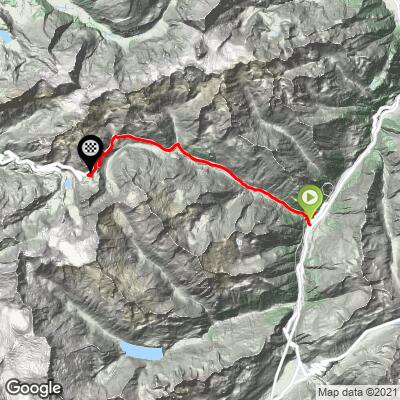
Ride 18.1 kilometers gaining 1,225 meters at 6.8% average grade.
This is a very scenic Suisse bike climb over a steady grade that rarely varies from 5-8%. This climb is also included in the Suisse cycling marathon Alpenbrevet which is a monstrous 5 mountain passes (Susten, Grimsel, Nufenen, Lukmanier and Oberalppass), 264 kilometers and 7,170 meters of climbing.
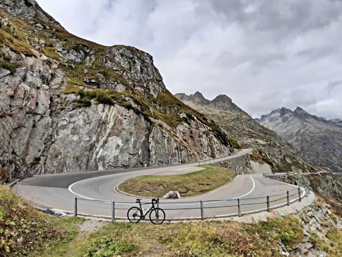
Our route goes 330 meters past the actual Sustenpass and ends at the Guesthouse Sustenpass (bonues of 282 meters altitude gain at 13%).
![]()
Sustenpass is in the bike climbing area of Gletsch - within a 40 kilometer radius of Gletsch are Sustenpass, Furkapass, Grimselpass, Gotthard Pass and 3 Top World Climbs (Breithorn #9; Mannlichen #55 and Marjalensee #81). It has been included in the Tour de Suisse several times but its most recent appearance in 2019 (as of 2020) in the Queen Stage was cancelled due to adverse weather conditions.
![]()
![]()
![]()
![]()
Warning: Bring taillight and headlight for tunnels on this route.
For Sustenpass there are also 2 very small tunnels at the start just outside Wassen and then a long gallerie. The gallery does offer a sidewalk for pedestrians and you can cycle there if you like even though it is quite narrow. I tried that on the way back and as it is so narrow you need to descend slowly and I was overtaken by cyclists who just followed the road. Hence my suggestion is to just follow the road. I did the same for the 2nd half of the galery myself.
Climb Summary from PJAMM Ambassador Helmuth Dekkers:
From Wassen the road swings with a big turn to the right and then after 350m bends left to pass below the nice stone arches of the railroad bridge. Then the road sneaks through the rocks with some tight bends and two small tunnels (120m and 60m) before the first hairpin is encountered. After 1.7km you'll reach an 800m long gallery that starts with a 60m tunnel that protects the road against rock fall. If you don't fancy the road that is protected by the gallery then you can cycle between the fench and the pillars that support the roof of the gallery. It's narrow but you can cycle there. Not that any cyclist does that as the road is perfectly fine for cyclists. And as the gallery is open to the left you are well visible for the other traffic. Though it it is not a very busy road. The road straightens out now and folows the Meienreuss river.
After 9.6km the road turns 90 degrees to the left. You have gained 700 meters in height and this results in an average gradient of 7.2%. One kilometer further up the road goes through the rock. You can hardly call it a tunnel as it is just 30m long and after it the road swings 90 degrees to the right again. Then again a long, 3.1km, rather straight piece of road before the road swings with 90 degrees to the left again and you can see a glacier above you and the saddle where the pass is located is also in sight. The road then crosses via 2 stone bridges and the same amount of hairpins over a little river and you get to the final part up to the 300m long tunnel that will bring you to the actual pass. If the weather is good you can look to the mountains and the ascent towards Innertkirchen. From the pass a short (300m) and steep (13%) road takes you up to the Berggasthaus Sustenpa
![]()
Thank you Helmuth!!
Susten is included in the Grand Tour of Switzerland which is a famous motor vehicle route that takes in many of the amazing and scenic views of Switzerland.
![]()
Grand Tour of Swizerland
1600 kilometers, 22 lakes, 5 alpine passes 12 UNESCO World Heritage sites.
In addition to Sustenpass, the Grand Tour includes Gotthard Pass, Grimselpass and Furkapass in this area.
I asked Helmuth if how he felt cycling through the tunnel at the finish:
“I felt perfectly safe to cycle through the tunnel. But, at the time there were construction activities ongoing and there was a traffic light to allow traffic from either direction. If you bring a tail light and front light (the tunnel is lit but then you are more visible to cars approaching you) then you should be fine.”