![]()
![]()
Ride 15 kilometers gaining 1,244 meters to 1,611 meters elevation at 8.2% average grade.
Ride summary from PJAMM’s good friend and climbing companion Ard Oostra, Switzerland.
Blåhö (BIG no. 4)
Blaho is one of the higher Norwegian summits that can be climbed by bicycle. In some 15 km we climb 1,257m to the 1,611m summit. The climb starts in the Village of Vagamo which is accessed by National Road 15 that runs along Lake Vagavatnet for the 10 km’s leading to town.
![]()
Looking back at Lake Gagavatnet and Vagamo.
During the climb, the blue-greyish colored lake can be observed from different altitudes and angles, increasing even more the scenic aspect of this cycling experience.
From the start and for some 6 km the road winds up steeply gaining some 700 m in altitude. For the first 2 kilometers, the road is newly asphalted and then turns into a smooth gravel road for the next 10 kilometers, but it is coarser and a little more difficult over the last 3 km.
The climb can be done on a road bike without too much trouble, although when wet there are some spots where the ground is a bit softer and the going more challenging, but manageable nonetheless.
During the first 5 kms of the climb we pass by pass small and well maintained farm houses with attractive gardens, some fields and forest.
![]()
Start of climb
![]()
Village in first 5 km
After 5 km, the scenery transitions to a more stark and barren appearance with short bushes and mountain tundra. Between km 6,5 and 9,5 the road is less steep and the cyclist can enjoy unobstructed views over the barren land, mosses and stones as far you can see.
![]()
Between km 10,5 and 12 the gravel road becomes steeper again.
![]()
The summit with its tower only becomes visible after km 12. We ride over a section of two fairly flat kilometers as a gentle approach to the 12% final kilometer curving to the right and up to the summit.
![]()
![]()
Winds can be strong in the last kilometers making it a challenge to stay on the bike, especially there where there is some loose gravel on the road.
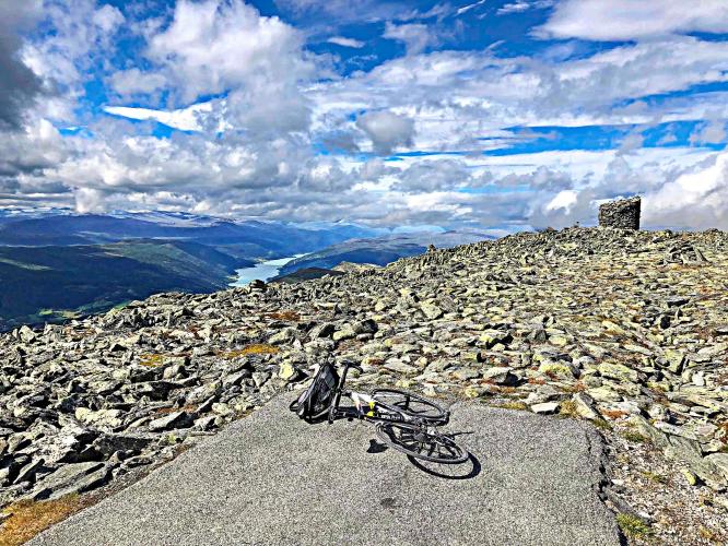
Arriving at the summit, we are rewarded with breathtaking 360 degree views that include Lake Gagavatnet 1250m below and to our west.
![]()
Weather can greatly vary at these altitudes in Norway, even in summer. The photos illustrating this climb were taken mid August, and at the summit the northwesterly winds were quite strong and the temperature of 3 to 4 Celsius dropped to -5 with wind chill.
The downhill was enjoyable with exceptional views in front of us the entire descent, but be cautious not to puncture. .
Ard Oostra, Switzerland
August 2018
(ArdWorks2018)

 We've partnered with Sherpa-Map.com to bring you the best route planning tool. With a PRO Membership you can use this climb as a reference when creating your route.

