![]()
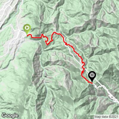
The third climb of my trip to Colombia with Colombia Bike Tours, a group we trust and highly recommend for Colombian cycling tours, was Alto de La Linea. Ranked as Colombia’s second hardest climb, and #50 in the world, Linea ascends 5,500ft in just 12.5 miles for an 8% average gradient.
This write up picks up where I left off after my second climb of the week in Colombia, El Limonar. If you’d like to read through the timeline of my trip, starting with Picacho, it might help you understand some of the aspects in this write up, but if not, continue on!
Getting there:
After absolutely smoking myself up El Limonar in Medellin, I was super excited for my first rest day of the trip. We got to sleep in a little the next morning, and after rising and eating breakfast in Medellin, we hit the road to drive to Salento, which is where we were staying the night before the ride up Alto de La Linea. Salento was about a 30 minute drive from the start of Linea, but we had decided to stay there so we had the opportunity to see “El Valle de Cocora”, one of the most popular tourist destinations in the area.
![]()
El Valle de Cocora, a truly magnificent place!
We woke up early the next day, and after eating breakfast at the hotel, kitted up and drove to El Valle de Cocora, which was only 10 or so minutes away. Any regrets I had about not staying closer to the start of the actual climb were immediately dispelled the second we entered into the valley. The Cocora valley is located in the Central Cordillera of the Andean mountains and is part of Colombia’s Los Nevados National Natural Park (established 1973, 58,300 hectares/144,062 acres).
I have been fortunate enough in my life to visit so many truly beautiful places around the world, but there are very few places my travels have brought me that match how incredible the Valle de Cocora was. One of those places that takes your breath away, and leaves you struggling to find words to describe it. Such an amazing place, with green in every shade you can imagine. We highly recommend visiting if you get the chance!
![]()
Linea is the main road to the town of Ibague, which is one of the larger towns on the way to Bogota
The Climb:
After a time, we reluctantly left El Valle de Cocora for our 30 minute car ride to the start of Alto de La Linea in Calarca. We parked on the side of the road to buy some Gatorade (maracuya, aka passion fruit Gatorade is the best flavor of all time) , and to set up my bike, and then I hit the road, starting the 5,500ft climb.
![]()
The base of Alto de La Linea. 5,325 feet above sea level.
I need to start by saying that this climb was very different than the previous two climbs I had done in Colombia. The scenery was similarly incredible, as was the perfect weather, but where Linea differs from my other Colombian climbs was the disconcerting amount of traffic on the road. As mentioned above, Alto de La Linea is the main highway to Bogota from the surrounding area, which obviously results in substantial vehicular traffic - we weren’t in Kansas anymore Dorothy . . . I had been forwarned and was prepared for cars, but what I wasn’t ready for was the staggering number of freight trucks on this route. From the second I started up the climb, I was constantly getting passed by huge, black-cloud spewing trucks!
![]()
My photographer, Javier, did a great job all day at timing his pictures when there were no trucks around!
I think he got a total of 5 photos, ha, ha . . .
At just about 12.5 miles long, but still climbing 5,500’, I was prepared for Linea to be a tough, steep ride. Despite my previous day’s rest, my legs were still pretty toasted from my brutal effort up El Limonar, so I began the climb a bit gingerly but keeping a decent pace . . . I think . . . We had decided that we wanted to spend that night in Bogota, which meant we had another 7 hour drive following the ride, so I was motivated to make it to the top quickly!
![]()
If there’s one thing all of the climbs I did had in common, it was awesome curves!
God bless the hairpin . . . switchback . . . tornante . . . kehre . . . lacets . . . curva de horquilla . . .
PJAMM loves those bendy things!
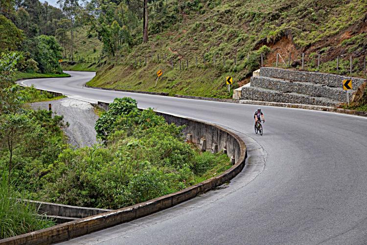
It was pretty crazy for me to experience such a different ride from the previous two I had done in Colombia. The scenery and land surrounding the road was just as beautiful as the other rides, but the constant cars and trucks passing made it a lot harder to enjoy and appreciate. Drivers in Colombia are very considerate, and genuinely try to give adequate space and pass at opportune times (we had the same “pleasant” experience on Alta de Letras in 2017), but the sheer volume of big-ass trucks seemingly constantly passing me was a bit stressful - this is not a ride for those not fully comfortable with highway traffic.
![]()
As you can see, there was not much of a shoulder at all
Halfway up the climb, we stopped for a couple of minutes to fly the drone, and to refill my bottles (once again, maracuya Gatorade for the win - YES!), and then continued up the road. Although our “rest” stop was at roughly the midway point of the ride, we still had a majority of the climbing to go - ouch - Warning: Steep Ahead!
![]()
If I had to describe the entire country of Colombia in one word, it would have to be “green”
At this point, the road started to get much more serpentine, with some pretty tough curva de horquillas. While the gradient kicked up really high in the pex of these hairpins, what made them most difficult was the narrow width of the curves which left little space for a big truck hugging the inside with a cyclist inside that! I had a tough go of it up this climb and I’m sticking to just one excuse - big-rig exhaust emissions . . . Nevertheless, extraordinary surroundings are a helpful distraction while I did push the pace up the climb - as much as I was capable.
![]()
Colombia, and its many steep turns, definitely improved my skills at climbing out of the saddle!
As my bike computer ticked off the distance to go on the climb, it seemed as if I started feeling stronger and stronger. For some reason, even though it was just as steep, I picked up the pace even faster on the last 2 miles or so of the climb. After cruising through one of the more scenic curves of the ride, I looked down at my computer and saw I only had a mile left to go, so I gunned it - well, it felt that way after nearly 3 Top 100 World Bike Climbs in 4 days.
![]() \
\
Such an amazing road, but dang, so many cars and trucks!
About a half mile from where my computer was telling me that the climb ended there was a huge poster with Nairo Quintana (El Cóndor de los Andes/The Lion; a revered Colombian cyclist - national hero - El Con - #1 2014 Gir, #2 2017; #2 TdF/KOM 2013, 2015, #3 2016; #1 Vuelta 2016) on it talking about the climb, so I figured that was where most of the people stop riding. However, my computer told me that the actual highest point of the road was about a half mile on, so I kept on the pedals.
![]()
My driver and photographer were expecting me to stop, but I just kept smashing
Once I finally reached the actual top of the climb, I had done 220 Watts average for about 2 hrs and 20 min, which was definitely a personal best for me. Considering I had done two tough climbs in the beginning of the week, and was at a high elevation, I was super happy with how I did on the climb. Overall, despite all of the cars and trucks, I still had a really awesome time climbing Alto de La Linea, and would highly recommend it to anyone who gets the chance!
![]()
Truly a great ride! Colombia is incredible for cycling.
As the last major climb of my week in Colombia, my mind was understandably bummed to be done riding, but my body was ready for a break. I had done 3 of the hardest climbs in Colombia in only 4 days!
![]()
What a week, Colombia! Almost 17,000 feet of climbing in only 54 miles (and only 3 rides)!
A very gracious thank you to Colombia Bike Tours for making our Colombia trip possible and assisting us in documenting one of the greatest climbs in the world. This is a professional, trustworthy and friendly group that we highly recommend.
Our photographer for the trip was Javier Chacon Mendoza, and we were very happy with his talents as both a camera man and a drone pilot. If you are ever in South America and are looking for some amazing photography and film from either the ground or skies, send him an email at javier.chacon.mendoza@gmail.com