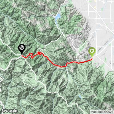
11.3
PDI
6.8 mi
DISTANCE
2,093 ft
GAINED
5.8 %
AVG. GRADE
FULL CLIMB STATS
INTRO
This is a very popular bike climb from Saratoga up Hwy 9 into the Santa Cruz Mountains. The climb begins in Saratoga and is one of the best and most efficient ways to access many of the wonderful bike climbs in the heart of the Santa Cruz Mountains (see PJAMM's Santa Cruz County). The summit is at Saratoga Gap and the intersection just beyond is known as Four Corners.
PLAN YOUR ROUTE
This is a moderate climb with a 5.8% average grade. 74% (5.1 miles) of the climb is in the 5-10% range and no section of the climb ever reaches double digits. The steepest quarter mile is 8.2% and steepest mile 7.9%.
See more details and tools regarding this climb's grade via the “Profile Tool” button above.
Roadway: 2 lanes in excellent condition.
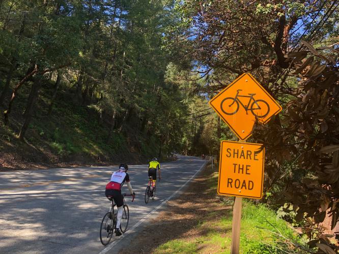
Traffic: Moderate to heavy - with a narrow shoulder on the uphill side most of the climb. While traffic can be heavy, it does not move at high speed.
Parking: Can be tough in Saratoga - if it is non-school hours, we park at Saratoga Elementary School near the start of this and the Bohlman Road climbs - Map; Street View.
Provisions: None on the ride, but plenty in Boulder 14 miles south.
Before heading out on any cycling adventure check out our Things to Bring on a Cycling Trip and use our interactive check list to ensure you don't forget anything.
There are many wonderful climbs to explore in the Santa Cruz Mountains - see Routes in Area button just below the featured image above or our Santa Cruz County page.
When traveling to the Santa Cruz Mountains to cycle, you might choose to stay in Saratoga or Santa Cruz. There are also great options for house rentals in the area.
ROUTE MAP
MEMBER RATING
CURRENT WEATHER
PJAMM TRIPS ADVENTURE STARTER BUNDLES
Check out PJAMM Adventure's prepackaged (self-guided) cycling trips. They will help you plan, document and conquer your next adventure.
NEARBY CLIMBS (0) RADIAL PROXIMITY
FROM No Climbs Found
MEMBER REVIEWS & COMMENTS
Let us know what you thought of this climb. Signup for our FREE membership to write a review or post a comment.
Already have an account?
LOG IN HERE
Adrian
the ascent isn't too bad, and easier than montebello climbing wise but there is a good amount of traffic. the descent is pretty great for the amount of climbing you do, and there are a decent amount of corners
NeillNorman
Scenic, but a busy road so not the greatest ascent. As a descent, on the other hand, it's absolutely fantastic. Wide road and banked corners: take a lane and fly.
jthurber80
This is a great climb but you do end up hear the southern end of Skyline Blvd. Vehicle traffic has increased since one of our local roads (Highway 84, Woodside Road) was closed due to a slide and isn't expected to reopen until July, 2023, at the earliest.
It's a steady climb, not too steep, and a superlative ride if you climb up and return the way you came - downhill. I hit 45 mph once (once) and got tagged by the local police. No ticket as I remarked to his question about my speed was, "Sir, I was too terrified to look at the speedometer!"