9
PDI
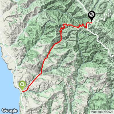
9.4 mi
DISTANCE
2,082 ft
GAINED
3.9 %
AVG. GRADE
FULL CLIMB STATS
Page Contributor(s): Mike Persellin, Minneapolis, MN, USA
INTRO
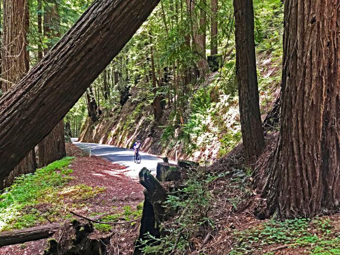
Tunitas Creek is the most scenic and epic bike climb in San Mateo County. The climb takes us through a gulch following Tunitas Creek much of the way. We highly recommend this spectacular bike climb.
Tunitas Creek is PJAMM's selection for seventh most scenic bike climb in the Bay Area. The PJAMM Adventure App's preloaded trip for the Bay Area'sTop 10 Most Scenic are viewed near the bottom of this page.
PLAN YOUR ROUTE
The average grade of this climb is 3.9% (5% with descent eliminated). 38% of the climb (3.6 miles) is at grade 0-5%, 41% (3.8 miles) is at 5-10%, and 5.4% (0.5 miles) is at 10-15%. The steepest quarter-mile on the climb is 9.5% and steepest continuous mile 8.6%.
See more details and tools regarding this climb's grade via the “Profile Tool” button.
Roadway: Narrow two-lane with no center stripe and in good condition in 2020.
Traffic: Minimal.
Parking: Near the start of the climb - Map; Street View.
There are no provisions on this climb.
Before heading out on any cycling adventure check out our Things to Bring on a Cycling Trip and use our interactive check list to ensure you don't forget anything.
This is a great out-and-back if coming from the east (Woodside, Portola Valley) done in tandem with Kings Mountain Road - 27 miles gaining 3,900' (Map). You could stay in nearby Woodside, where there are also vacation rental options.
ROUTE MAP
MEMBER RATING
CURRENT WEATHER
PJAMM TRIPS ADVENTURE STARTER BUNDLES
Check out PJAMM Adventure's prepackaged (self-guided) cycling trips. They will help you plan, document and conquer your next adventure.
NEARBY CLIMBS (0) RADIAL PROXIMITY
FROM No Climbs Found
MEMBER REVIEWS & COMMENTS
Let us know what you thought of this climb. Signup for our FREE membership to write a review or post a comment.
Already have an account?
LOG IN HERE
NeillNorman
Amazing ride - not to be missed. Best redwood cathedral in the Santa Cruz Mountains. Don't let the 3% avg. grade fool you - middle section is plenty steep.