
16.1
PDI
5.7 mi
DISTANCE
2,362 ft
GAINED
7.8 %
AVG. GRADE
FULL CLIMB STATS
INTRO
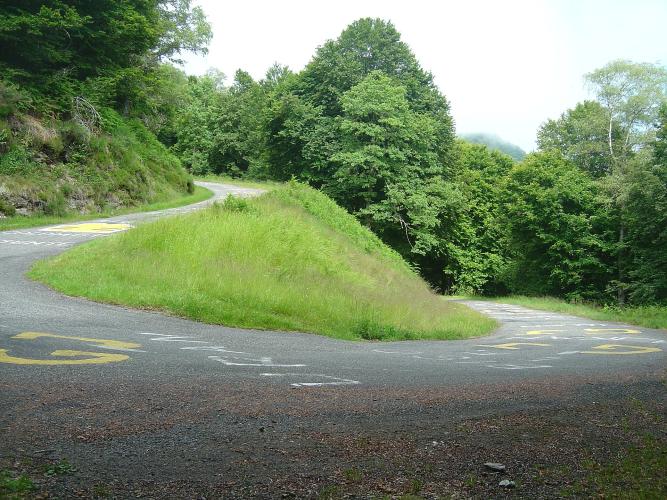
For almost 6 km the Mur de Péguère is a pleasant ride up the Col de Port road out of Massat. Then, just past the Col des Caougnous, you turn onto a lane barely wider than a car, and the next 3.5 km average 11.7%. A road sign warns of 18%, and it isn't exaggerating by much.
From Massat it's 9.2 km (5.7 mi) with 720 m (2362 ft) of climbing at 7.8%. The first 5.7 km on the wide D618 average 5.5%. After the turn the D17 climbs through forest and is at its worst straight away - the steepest kilometer is 13.4% and the hardest half-kilometer 14.1% - before easing to about 10% for the last kilometer and a half.
The Tour planned to use Péguère as far back as 1973, but dropped it when riders objected to the descent. It first went over as a rated climb in 2012, when someone scattered tacks on the road at the summit and around 30 riders punctured. It has been back in 2017 (Warren Barguil first over the top), 2019 (Simon Geschke) and the 2022 Tour, when Hugo Houle led over it on Stage 16 and went on to win alone in Foix.
At the col there's an orientation table, a stone shepherds' shelter and a view south to Mont Valier. A big panel tells the story of the Guerre des Demoiselles, the 1830s uprising in which Ariège villagers disguised as women fought the new laws that shut them out of the forests.
PLAN YOUR ROUTE
 We've partnered with Sherpa-Map.com to bring you the best route planning tool. With a PRO Membership you can use this climb as a reference when creating your route.
Overall: 9.2 km (5.7 mi) from 613 m (2011 ft) at Massat, gaining 720 m (2362 ft) at an average of 7.8%.
The shape: 5.7 km (3.5 mi) at 5.5% on the D618 to the Col des Caougnous, then 3.5 km (2.2 mi) at 11.7% on the D17 - the Mur itself.
Kilometer by kilometer: 5.9%, 5.8%, 4.9%, 4.5%, 5.9%, 8.2% (the turn comes near the end of this one), 12.5%, 12.3%, 10%, and 9.9% for the final 0.2 km.
Steepest sections: 0.5 km at 14.1%, 1 km at 13.4%, 2 km at 12.9%, 5 km at 10%. Riders report short stretches near 18% around a hairpin in the first steep kilometer after the turn, where a sign warns of the gradient.
Roadway: Paved throughout. The D618 to the Col des Caougnous is a two-lane main road in good condition. The D17 above it is a different thing: single-lane, shaded by forest, with painted riders' names still on the tarmac in places. Going up, the surface is fine; coming down is the hard part - it's steep enough that riders have overheated rims and burst tubes, so brake in pulses and take it slowly, or descend the gentler north side toward Foix instead. Snow and ice can linger in the forest outside summer, so check Ariège's Inforoute09 road information before riding between late autumn and spring.
Traffic: The D618 carries steady through traffic between Massat and the Col de Port. Once you turn onto the D17 there's very little - a few locals, walkers heading for the col and other cyclists.
Parking: Park in the center of Massat and roll out to the start on the D618. There's nowhere to leave a car at the Caougnous turnoff and only a little roadside space at the col.
Gear: This is the climb to bring your lowest gear for. A 34x32 or 34x34 is not overkill for 3.5 km at nearly 12% with ramps of 14-18%, and you'll want to be seated and spinning, not standing and grinding, by the second hairpin. Fresh brake pads matter just as much for the descent.
Provisions: Stock up in Massat. There's no water on the climb or at the col, and if you go down the far side, the next shops are well down the Arget valley toward Foix.
Before heading out on any cycling adventure check out our Things to Bring on a Cycling Trip and use our interactive check list to ensure you don't forget anything.
Massat is a small village of around 750 people now, but in 1831 it had more than 9000, when the valley lived from charcoal, iron and summer grazing. It sits on the old Route des Pyrénées, so the Col de Port, Port de Lers and the Col de Péguère all start within a few kilometers of each other.
From the col, three roads make loops easy. Go west along the ridge to the Col du Portel and down to Biert - our Col du Portel (Biert) page covers that side - or north down the D17 toward Foix, where our Prat d'Albis climb starts on the edge of town. The 2019 Tour stage strung together Port de Lers, Péguère and then the finish on Prat d'Albis, which makes a hard but very good day out.
ROUTE MAP

MEMBER RATING
CURRENT WEATHER
PJAMM TRIPS ADVENTURE STARTER BUNDLES
Check out PJAMM Adventure's prepackaged (self-guided) cycling trips. They will help you plan, document and conquer your next adventure.
NEARBY CLIMBS (0) RADIAL PROXIMITY
FROM No Climbs Found
MEMBER REVIEWS & COMMENTS
Let us know what you thought of this climb. Signup for our FREE membership to write a review or post a comment.
Already have an account?
LOG IN HERE
carlinguernsey


The first 6k is your warm up. Once you turn off the lower slopes of the Col de Port onto the Mur, the fun begins when you are greeted by an 18% sign. I spent the first k struggling to keep moving forward. The second k was marginally more bearable. After that it is "only" 10% to the top. You also have to hope that there are no cars because the road is very narrow. This must be one of the toughest 3.6k climbing stretches in France. Make sure your brakes are in good shape if you descend also.
Achille_Stybar89
Last 3.6km at 11.8% ( average slope)
