22
PDI
13.1 mi
DISTANCE
3,908 ft
GAINED
5.6 %
AVG. GRADE
FULL CLIMB STATS
INTRO
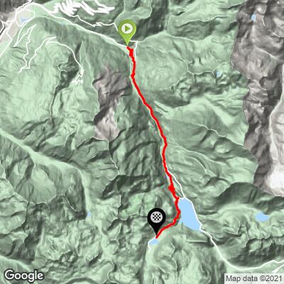
Montée de Tignes climbs 21.1 km (13.1 mi) up the D902 and D87A from the hamlet of Viclaire, in the commune of Sainte-Foy-Tarentaise, to the high-altitude resort of Tignes at about 2,094 m (6,870 ft). It gains 1,191 m (3,908 ft) at a 5.6% average, and it is the long, steady way up the Haute-Tarentaise, on the same road that continues to Val d'Isère and the Col de l'Iseran.
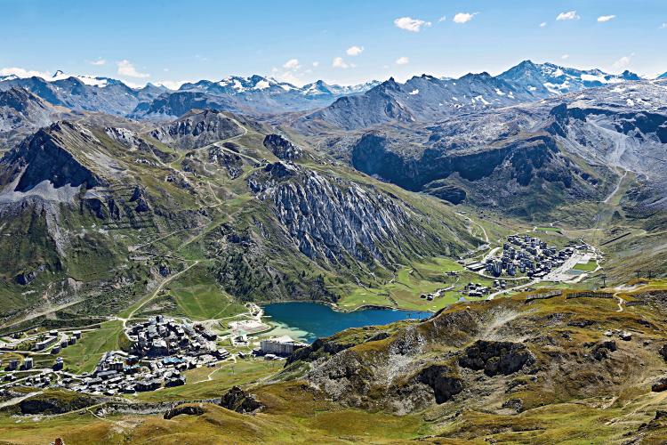
This is a climb of patience rather than a wall. Even the steepest kilometer averages only 8.9%, and the hardest 10 km (6.2 mi) averages 6.0%, so the effort is spread across the whole ascent instead of hidden in one ramp. The road works through a series of lit tunnels, passes Les Brévières, and near the top opens onto a view over the Tignes dam and the lake resort of Tignes, where Le Lac, Val Claret and Le Lavachet all sit at about 2,100 m (6,890 ft).
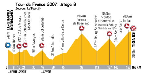
Tour de France 2021: Stage 9 (category 1) finished here on July 4, 2021, when Ben O'Connor was first to the top of Montée de Tignes after a day that also crossed the Col des Saisies and the Cormet de Roselend. It was the climb's second Tour finish after stage 8 of the 2007 Tour. A planned finish here in 2019 never happened - the stage was halted on the Col de l'Iseran by hail, snow and a mudslide.
PLAN YOUR ROUTE
 We've partnered with Sherpa-Map.com to bring you the best route planning tool. With a PRO Membership you can use this climb as a reference when creating your route.
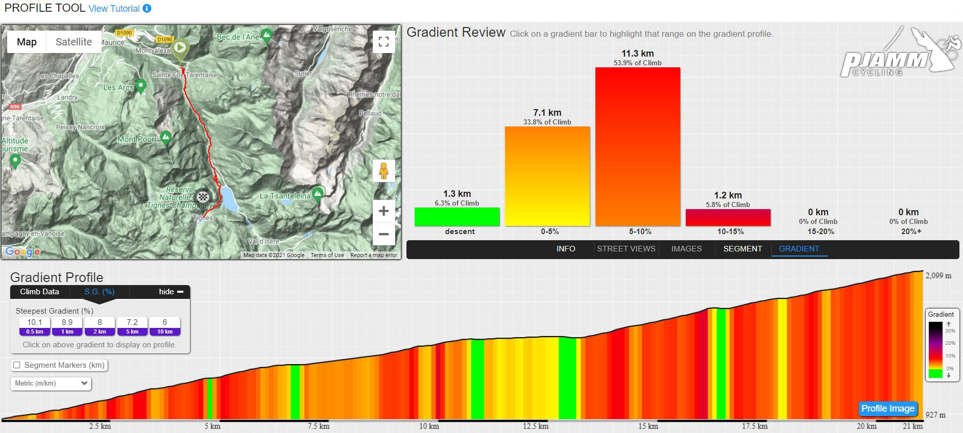
 The average grade is 5.6% over 21.1 km (13.1 mi), climbing from about 927 m (3,040 ft) at Viclaire to about 2,094 m (6,870 ft) at the finish, a gain of 1,191 m (3,908 ft).
The climb never gets truly savage, but it does bite in short places. The steepest 90 m (100 yards) averages 13.7%, the steepest 0.4 km (0.25 mi) 10.9% and the steepest 0.5 km (0.3 mi) 10.1%. Over longer stretches the numbers settle quickly: the steepest kilometer (0.6 mi) averages 8.9%, the steepest 2 km (1.2 mi) 8.0%, the steepest 5 km (3.1 mi) 7.2% and the steepest 10 km (6.2 mi) 6.0%.
That last figure is the useful one. Because the hardest 10 km is only slightly above the overall average, there is little to gain from attacking any single section - ride a steady effort from the start and you will still have legs for the ramps as you climb into the 2,000 m (6,560 ft) range, where the air thins.
Roadway: The D902 and D87A are paved the whole way. The road climbs through a series of tunnels, including the Brévières and Chevril tunnels, so front and rear lights are essential rather than optional. The tunnel lighting and electrical equipment is periodically serviced with overnight closures (as it was in June 2025), so check the Savoie road-conditions service if you are planning a very early or late start.
Traffic: This is the main access road to Tignes and on to Val d'Isère, so expect steady traffic, and it is most noticeable in the tunnels. Rider reports describe the pavement as a mix of great and acceptable condition.
Parking: The climb starts at Viclaire, a hamlet within Sainte-Foy-Tarentaise. Sainte-Foy's outdoor car parks are free in summer, which makes the village the practical place to leave a car. If you would rather base yourself lower in the valley, Bourg-Saint-Maurice is covered on our Cormet de Roselend and Arc 2000 pages.
The finish is nearly 1,200 m (3,900 ft) above the start, and Tignes sits at about 2,100 m (6,890 ft), so it can be many degrees cooler at the top than in the Isère valley even in July. Carry a windproof layer and arm or knee warmers for the descent, which runs back through the same tunnels.
Lights front and back are the one item this climb genuinely requires - wear something bright and reflective too. Fill your bottles before you start, since the climb is long and steady, and expect resort services rather than shops along the way once you reach Tignes.
Before heading out on any cycling adventure check out our Things to Bring on a Cycling Trip and use our interactive check list to ensure you don't forget anything.
Tignes has an unusual backstory for a ski resort. The original village stood at about 1,700 m (5,580 ft) in the Isère valley until the dam was completed in 1952 and Lac du Chevril flooded it, and the residents were relocated. The dam is an arch dam around 180 m (590 ft) high, and it carries an enormous Hercules fresco painted by a team led by Jean-Marie Pierret in 1989 for the Olympic era - Tignes hosted the freestyle skiing events at the 1992 Winter Olympics. The lake is drained for maintenance roughly once a decade, which is when the old village briefly reappears.
The finish area is a cluster of three villages - Tignes Le Lac, Val Claret and Le Lavachet - all at about 2,100 m (6,890 ft). Tignes also runs an "Accueil Cyclo" label for accommodations that offer a closed bike room, small repair equipment, laundry and a sports breakfast. If you have legs left, the road continues to Val d'Isère and up the Col de l'Iseran. Because the finish sits above 2,000 m (6,560 ft), check current conditions before you go with our Weather tool.
ROUTE MAP
MEMBER RATING
CURRENT WEATHER
PJAMM TRIPS ADVENTURE STARTER BUNDLES
Check out PJAMM Adventure's prepackaged (self-guided) cycling trips. They will help you plan, document and conquer your next adventure.
NEARBY CLIMBS (0) RADIAL PROXIMITY
FROM No Climbs Found
MEMBER REVIEWS & COMMENTS
Let us know what you thought of this climb. Signup for our FREE membership to write a review or post a comment.
Already have an account?
LOG IN HERE