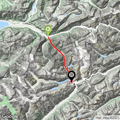
Cycling Grimselpass from Innertkirchen
Ride 26.7 kilometers gaining 1,540 meters at 5.8% average grade.
Grimsel Pass is situated in the Bernese Alps, in the western part of the canton of Bern. It's one of several stunning mountain passes in the area, known for its breathtaking scenery and its role as a popular route for both motorists and cyclists.
![]()
Grimselpass is a key player in the Andermatt Cycling Region and is one of the Big Four in the neighborhood which includes Furdapass, Nufenenpass, and the incomparable Gotthard Pass. This side of Grimselpass is to the west of the Furkapass-Gotthard Pass-Nufenenpass-Grimselpass route. If one were into an extreme cycling day, you could do the uber-challenging Grimsel-Furka-Gotthard-Nufenen-Grimsel loop (180 kilometers, 6,625 meters). If you do this route, please notify us as we’d love to report it here.
START OF CLIMB

Start the climb in Innertkirchen (2018 population 1,063).
![]()
Head south towards Gletsch for Grimsel and Furka Pass;
Travel northeast for Susten Pass.
Life in this region dates back to the middle ages -- Roman coins and a Roman rest station have been discovered here. The first hydroelectric plant was built in the area in the 1920s.
START TO THE DAMS

Ride from Innertkirchen to the first dam 19 kilometers at 5.7% average grade.
Grimselpass was featured in the 2007 Tour de Suisse as a mountain top finish at Stage 7, on June 22, 2007 (Ulrichen to Grimselpass 125.7 km). The stage was won by Vladimir Gusev (RUS).

As is the case with all the bike climbs in this area, the scenery on Grimselpass is spectacular.
The first 20 kilometers of the climb are generally in an alpine setting.
![]()
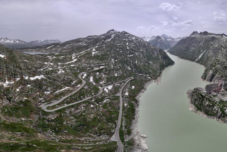
We ascend beyond the tree line upon reaching the first of two dams, namely the Räterichsboden Staumauer. As we progress further, our path unfolds amidst the imposing and rugged gray granite mountainsides

We encounter the first two tunnels on the climb at at kilometers 4 and 12.
TUNNEL TO THE DAMS
![]()
Be sure to take the alternate route around tunnel at kilometer 16.
![]()
DAMS TO THE FINISH
We encounter two dams on Grimselsee (Lake Grimsel) near the top of our ascent.
DAM 1: RÄTERICHSBODENSEE
![]()
The first dam we encounter is Räterichsbodensee at kilometer 19.7
![]()
We pass Räterichsbodensee for 1.6 kilometers of nearly flat riding.
![]()
From Räterichsbodensee dam to Grimselpass is 7 kilometers averaging 5.7%.
DAM 2: GRIMSELSEE
![]()
We pass Grimselsee at kilometer 23.
This is the largest hydroelectric reservoir in the region.
![]()
Grimselsee is the large lake middle of photo; Räterichsbodensee is the smaller lake behind Grimselsee.
![]()
Approaching Grimselsee dam.

Photos along the approach to Grimselsee dam.
These ground level photos are taken between kilometers 21 and 23.

From the end of Räterichsbodensee to Grimselpass we ride 5.4 kilometers averaging 7%.
HAIRPINS UP TO GRIMSELPASS
![]()
The final hairpins to Grimselpass - 2.5 kilometers at 7.6% average grade.
![]()
Grimselpass and Totensee left; Grimselsee right.
FINISH

At the summit, there are hotels and a natural lake.
Note Totensee is fresh water blue, versus Griselsee’s greenish glacier created color.
![]()
SWISS GRAND TOUR
Grimsel is included in the Grand Tour of Switzerland which is a famous motor vehicle route that takes in many of the amazing and scenic views of Switzerland.
![]()
Grand Tour of Swizerland
1600 kilometers, 22 lakes, 5 alpine passes 12 UNESCO World Heritage sites.
In addition to Grimselpass, the Grand Tour includes Gotthard Pass, Sustenpass and Furkapass in this area.
More information on Grimsel Pass:
“The Grimsel Pass (German: Grimselpass; French: Col du Grimsel) is a mountain pass in Switzerland, crossing the Bernese Alps at an elevation of 2,164 metres (7,100 ft). The pass connects the Haslital, the upper valley of the river Aare, with the upper valley of the Rhône. In so doing, and as the Aare is a tributary of the Rhine, the pass crosses the continental divide between the North Sea and the Mediterranean Sea.
A paved road follows the pass, running 38 kilometres (24 mi) from Gletsch to Meiringen. The road is normally closed between October and May, due to the high snowfall on the pass. As it is the only direct road pass between the cantons of Bern and Valais across the Bernese Alps, attempts are made to keep the road open as long as possible with snow ploughs. A PostBus Switzerland service uses the pass several times a day, connecting Meiringen and Oberwald.
The Grimsel Pass road is part of the Aare Route, which is national cycle route 8 of Switzerland. It has been used on several occasions by the Tour de Suisse.
History: The first fully documented use of the Grimsel Pass dates back to the 14th century, although it has been suggested that the pass was used in Roman times and also, in 1211, by troops of Berthold V, Duke of Zähringen. In 1397, the Landschaften of Pomat, Goms and Hasli, and the cities of Interlaken, Thun and Bern, signed an agreement in which it was agreed to provide for free and secure trade by the mule track over the Grimsel.
The Grimsel Pass formed, along with the Nufenen and Gries passes, a regional trade route between the Haslital and Domodossola and the Lombardy plain. Cheese and cattle were sent south, whilst wine, rice, corn and olive oil came north. This trade continued until the opening of the Gotthard railway in 1882.
The track over the pass was not upgraded to a paved road until 1894. Between the 1920s and the 1950s, several hydro-electric power plants were constructed in the area around the pass by Kraftwerke Oberhasli (KWO), which resulted in the expansion and diversion of the pass road. The KWO now promotes the pass and surrounding area as a visitor attraction, as part of its Grimselwelt tourism brand,” (Wikipedia - Grimsel Pass).