33.7
PDI
18.4 mi
DISTANCE
5,845 ft
GAINED
5.6 %
AVG. GRADE
FULL CLIMB STATS
INTRO
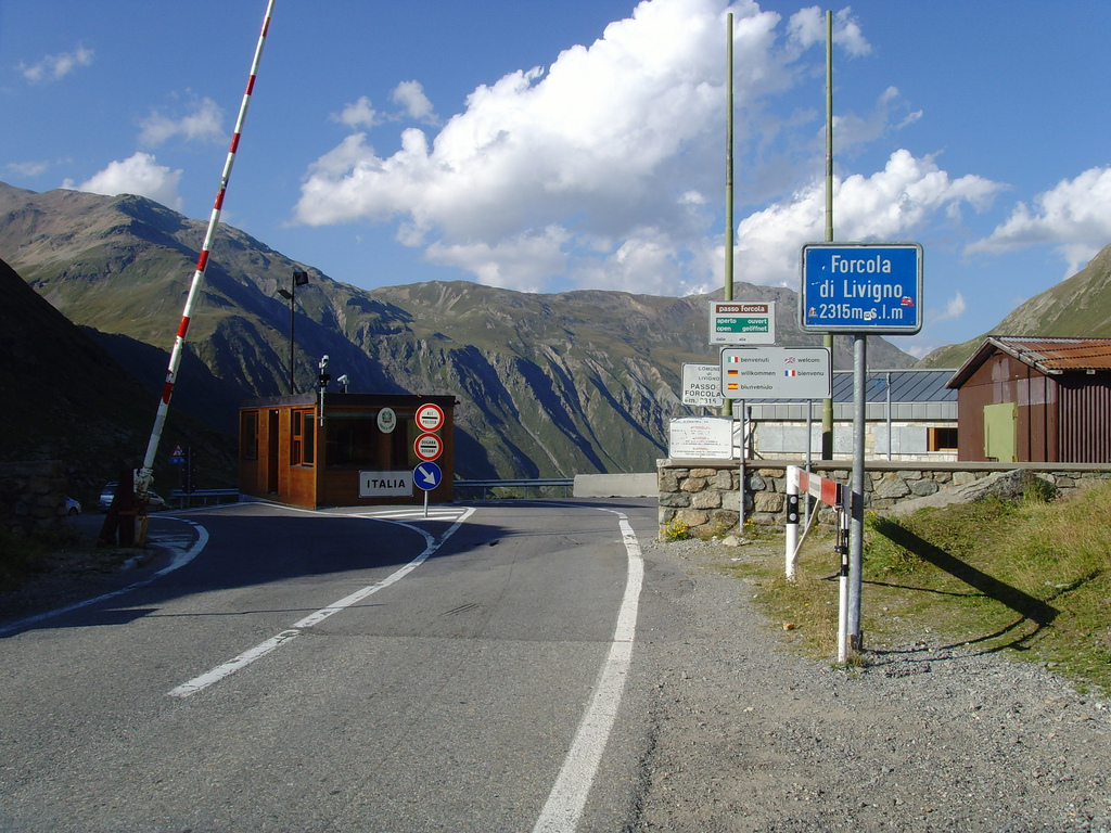
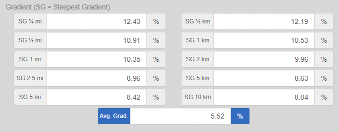
Forcola di Livigno climbs 18.35 miles and 5,845 feet from Brusio, Switzerland (2,231') up the Val Poschiavo to the Swiss-Italian border at 7,589', where the road crosses into Livigno, Italy at 2,315 meters. The average grade is a manageable 5.55%, but that number hides real variation - the steepest quarter-mile pitches up to 12.4%, and the switchbacks above the Bernina Pass turnoff bite hardest.
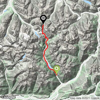
This is really two climbs in one. The first 25.7 km (about 16 miles) follow the same Roadway 29 that carries the well-known Bernina Pass climb - through Brusio's famous spiral viaduct (a highlight of the UNESCO World Heritage-listed Bernina Express rail line), past Lago di Poschiavo, and through the town of Poschiavo at km 10.8. Only at km 25.6, with most of the elevation already behind you, does the road split - Forcola di Livigno turns off toward the Italian border and Livigno, while the main Bernina Pass road continues on to St. Moritz.
Riders who've done it consistently describe the road as nicely paved and safe on both the Swiss and Italian sides, though narrower and quieter than the main Bernina route once you make the turn. Like most high Alpine passes in this part of Switzerland, the road is only open seasonally - typically from early June through late November, depending on snowfall - so check current conditions before planning a ride outside peak summer season.
PLAN YOUR ROUTE
 We've partnered with Sherpa-Map.com to bring you the best route planning tool. With a PRO Membership you can use this climb as a reference when creating your route.
 Forcola di Livigno gains 5,845 feet over 18.35 miles at an average grade of 5.55%, but the effort is not evenly distributed. The lower 10 miles through the Val Poschiavo - past Lago di Poschiavo and through the town of Poschiavo - are gentle, rolling along the valley floor well under 5%.
The real climbing starts above Poschiavo, where the road begins switchbacking toward the Bernina Pass turnoff. The steepest sustained kilometer averages 10.5%, beginning around km 2 past town, and the steepest quarter-mile on the whole route touches 12.4%. After the turn toward Livigno at km 25.6 (mile 15.9), the final push to the 7,589' summit holds in the 8-10% range through a handful of tighter hairpins before the road eases into the descent toward Livigno on the Italian side.
Roadway: The road is paved the entire way, from Brusio to the Swiss-Italian border at the Forcola pass summit, and riders consistently describe it as being in good condition on both the Val Poschiavo and Livigno sides. The pass is a seasonal Alpine road, typically open from early June through late November depending on snowfall, so confirm it's open before planning a ride outside peak season.
Traffic: Traffic is moderate for the first 16 miles/25.7 km, since this section is shared with Roadway 29, the main road up the Val Poschiavo and the primary route to the Bernina Pass and St. Moritz. Once the road splits toward Livigno at km 25.6, traffic drops off noticeably - most cars and coaches continue straight on toward the Bernina Pass summit rather than making the turn, leaving the final climb to the border quieter.
Parking: Brusio is a small village with informal roadside parking near the train station and the spiral viaduct viewpoint at the start of the climb. Riders coming from Tirano, Italy (about 15 minutes south) or from Poschiavo can also start partway up the valley if they'd rather skip the lower, flatter miles.
Poschiavo, at km 10.8, is the last real town on the route with grocery stores, cafes, and a pharmacy, so it's worth topping off water and food there before the grade kicks up. Above Poschiavo, services thin out quickly - pack enough food and water for the remaining hours of climbing.
A compact crank or a wide-range cassette is worth having; the average grade is moderate, but the steepest pitches near 10-12% come after 15+ miles of climbing, when legs are already tired. Because the pass tops out above 2,300m/7,500', temperatures at the summit can be noticeably colder and windier than in Brusio - pack a light layer even on a warm valley morning, especially if you're descending into Livigno on the Italian side afterward.
Before heading out on any cycling adventure check out our Things to Bring on a Cycling Trip and use our interactive check list to ensure you don't forget anything.
Brusio sits in the Val Poschiavo, a quiet, Italian-speaking corner of Graubunden best reached by car from Tirano, Italy, or by the Bernina Express/Rhaetian Railway from St. Moritz - a scenic approach in its own right, since the line's UNESCO World Heritage-listed spiral viaduct sits right at the edge of the village where the climb begins. Poschiavo, about a third of the way up, is worth a slower look if time allows - it's one of the best-preserved historic town centers in Graubunden, with Italian-influenced architecture that feels distinct from most Swiss Alpine villages.
Because Forcola di Livigno shares its first 16 miles with the Bernina Pass climb, riders based in the area for a few days can combine the two into a single trip rather than treating them as separate outings - see our Routes in the Area tool for other climbs nearby.
Livigno itself, just over the border on the far side of the pass, is a duty-free resort town with plenty of lodging, bike shops, and restaurants if you're continuing that direction rather than returning to Brusio.
ROUTE MAP
MEMBER RATING
CURRENT WEATHER
PJAMM TRIPS ADVENTURE STARTER BUNDLES
Check out PJAMM Adventure's prepackaged (self-guided) cycling trips. They will help you plan, document and conquer your next adventure.
NEARBY CLIMBS (0) RADIAL PROXIMITY
FROM No Climbs Found
MEMBER REVIEWS & COMMENTS
Let us know what you thought of this climb. Signup for our FREE membership to write a review or post a comment.
Already have an account?
LOG IN HERE