29.8
PDI
18.2 mi
DISTANCE
5,304 ft
GAINED
5.4 %
AVG. GRADE
FULL CLIMB STATS
INTRO
Bernina Pass climbs 29 km and gains 1617 m from Brusio, Switzerland to the 2331m summit above Lago Bianco, in the Val Poschiavo, canton of Graubunden. The average grade is a manageable 5.4%, though the road bites harder early - the steepest kilometer averages 8.7%, right near the start out of Brusio.
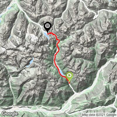
The route starts at Brusio's famous spiral railway viaduct, a stop on the UNESCO-listed Bernina Express line, then follows the valley past Lago di Poschiavo and through the historic town of Poschiavo (pop. 3,534). For roughly the first 26 km, this road is shared with two neighboring PJAMM climbs, Forcola di Livigno and Passo della Forcola - Poschiavo, both of which peel off toward Italy; Bernina Pass continues straight to the summit and carries the bulk of the valley's through traffic the whole way.
The pass has carried traffic over the Alps since the Middle Ages, and the first formal road across it was built between 1842 and 1865.
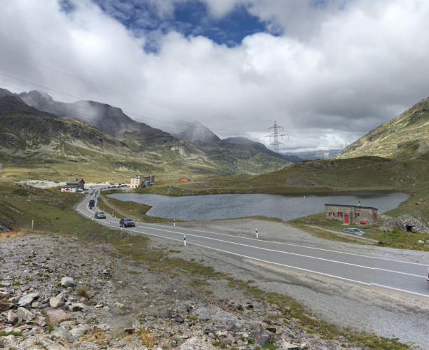
Unusual for a pass this high, Bernina Pass stays open year-round, aided by the parallel rail line crossing just west of the road at Ospizio Bernina - though winter tires and snow chains can be required, and conditions above 2,300 m turn cold and exposed even in summer. Lago Bianco's turquoise water and views toward the Cambrena and Morteratsch glaciers make the summit worth the effort on its own.
PLAN YOUR ROUTE
 We've partnered with Sherpa-Map.com to bring you the best route planning tool. With a PRO Membership you can use this climb as a reference when creating your route.
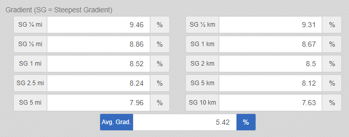
 Bernina Pass averages 5.4% over 29.3 km (18.2 mi) of climbing and 1,617 m (5,304 ft) of gain, but that average hides real variation. The steepest 100 yards reaches 9.9%, and sustained over a full kilometer, the steepest section still holds 8.7%. Stretch the window to a quarter mile or a full mile and the numbers ease only slightly - 9.5% and 8.5% respectively - which points to one genuinely steep early stretch rather than scattered short ramps.
Widen the lens further and the picture softens: over any 5 km window, the steepest stretch settles to 8.1%, and over 10 km it eases to 7.7%. In practice, that means the toughest riding comes in the opening kilometers out of Brusio, after which the grade turns moderate and sustainable for the long middle and upper portions of the route, right up to the final approach into Ospizio Bernina where it flattens out near the summit.
Roadway: The road is paved the entire way from Brusio to the summit, and riders consistently describe the surface as excellent on both the lower valley section and the high alpine stretch above Poschiavo. Bernina Pass is unusual among high Swiss passes in staying open year-round rather than closing for winter, though winter tires or snow chains can be required in poor conditions - check current road reports before riding outside the June-to-September window.
Traffic: Traffic is moderate for the first 26 km on shared Route 29. Where the neighboring Forcola di Livigno and Passo della Forcola - Poschiavo climbs peel off and see traffic drop, Bernina Pass continues on toward St. Moritz and carries the bulk of the valley's cars and tour coaches all the way to the summit. Each September, the Bernina Gran Turismo classic-car hillclimb temporarily closes the section between La Rosa and Ospizio Bernina for a weekend - check regional event calendars if riding in early-to-mid September.
Parking: Brusio's village center has informal roadside parking near the train station and the spiral viaduct viewpoint, the same start used by the neighboring Forcola di Livigno and Passo della Forcola - Poschiavo climbs. Riders from Tirano, Italy (about 15 minutes south) or based in Poschiavo can also start partway up the valley to skip the lower, flatter miles.
Poschiavo, about a third of the way up, is the last town with grocery stores, cafes, and a pharmacy - top off water and food there, since nothing else follows for the remaining 19 km to the summit. Because the pass tops out above 2,300 m, temperatures and wind at Ospizio Bernina can be noticeably harsher than a warm morning in Brusio; pack a real layer even in midsummer.
Unlike its two neighboring climbs, Bernina Pass does have a payoff waiting at the top: the seasonal Bernina Hospiz hotel and restaurant sits right on Lago Bianco at the summit, so it's not necessary to carry a full day's food if you're willing to buy a meal there.
A compact crank or wide-range cassette is still worth having for the steeper opening kilometers out of Brusio, when legs are freshest but the grade is at its toughest.
Before heading out on any cycling adventure check out our Things to Bring on a Cycling Trip and use our interactive check list to ensure you don't forget anything.
The Bernina Pass summit has its own hotel and restaurant, the Bernina Hospiz (Ospizio Bernina), open seasonally from June through November right on Lago Bianco with views toward the Cambrena Glacier - a real destination in itself, and one the neighboring Forcola climbs don't offer since neither reaches this side of the valley.
The Rhaetian Railway's Bernina line runs alongside the road the whole way and stops at Ospizio Bernina station, the highest on the line; regular regional trains carry bikes if you'd rather ride up and take the train back down (the panoramic Bernina Express cars themselves do not accept bikes).
Beyond the pass, the road descends into the Engadin valley toward Pontresina and St. Moritz, both well-stocked resort towns with lodging, bike shops, and rail connections on toward Chur or south to Milan if this is part of a longer trip.
Riders based in Brusio or Poschiavo for a few days can pair Bernina Pass with the neighboring Forcola di Livigno and Passo della Forcola - Poschiavo climbs, which share the same start for the first 26 km - see our Routes in the Area tool for other climbs nearby.
ROUTE MAP
MEMBER RATING
CURRENT WEATHER
PJAMM TRIPS ADVENTURE STARTER BUNDLES
Check out PJAMM Adventure's prepackaged (self-guided) cycling trips. They will help you plan, document and conquer your next adventure.
NEARBY CLIMBS (0) RADIAL PROXIMITY
FROM No Climbs Found
MEMBER REVIEWS & COMMENTS
Let us know what you thought of this climb. Signup for our FREE membership to write a review or post a comment.
Already have an account?
LOG IN HERE