![Cycling Mount Leinster from Bunclody, Ireland view of fork in the road]()
Cycling Mount Leinster from Bunclody, Ireland
Ride 14 kilometers gaining 778 meters at 5.2% average grade.
![Cycling Mount Leinster from Bunclody, Ireland photo collage shows views along the Mt. Leinster from Bunclody route; sign for Mt. Leinster Heritage Drive; aerial drone view of sheep in pastureland]()
One thing is for sure, this is (one of) Ireland’s cow territories! You’ll begin at a major junction in the heart of Bunclody and soon ride past many large farms and cattle ranches. Expect to see some really healthy looking Irish bovines. On the lower slopes, there are a decent amount of little downhills that break up some difficult steep sections. Once you make your left turn onto Road L3005, the farms and cattle are traded for unobstructed views and little vegetation. This increasingly steep mountain road eventually winds its way to a parking lot and junction point for the gated-to-cars access road to the summit. Once on the access road I never left my granny gear. Double digit grades will show no mercy until you reach the very top of the mountain at 2,566 feet of elevation.
![Cycling Mount Leinster from Bunclody, Ireland parking in Bunclody at the start of ride; bike parked against stone wall, street signs and informational signs for Mt. Leinster Heritage Drive]()
Park in Bunclody to begin the ride.
![Cycling Mount Leinster from Bunclody, Ireland PJAMM Cyclist rides on roadway surrounded by heavy foestation; sign for Mt. Leinster Heritage Drive]()
Climb begins by riding up Mount Leinster Heritage Drive at the east edge of Bunclody.
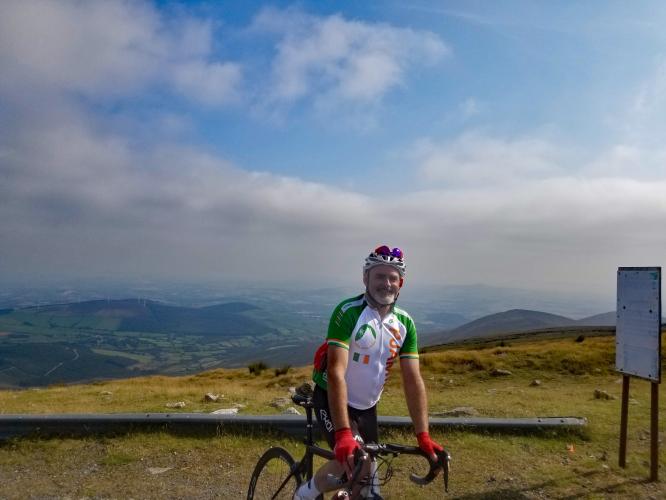
Climb summary by PJAMM ambassador Stephen Rochford of Longwood, Colorado and Meath, Ireland.
This is a great climb of 13.5 kilometers, with an average gradient of 5.4%. The first 11 kilometers are very manageable with a couple of short ramps hitting 10-12%, but for the majority of the time the road rambles nicely upward at 4-5% and even has a few short descents along the way.
![Cycling Mount Leinster from Bunclody, Ireland photo collage shows stone wall with pink flowers in front of it; sign for Monks walking, and fields with bales of hay]()
The roadway surface is in good condition, but the roads are quite narrow and will have traffic on the weekends and throughout the holiday season as this is a popular hiking area.
![Cycling Mount Leinster from Bunclody, Ireland photo collage shows views of Irish countryside, pastureland and white and brown cows grazing]()
There are good views of the mountain and surrounding area all the way up from Bunclody. As you get closer to the top, the landscape really drops away to your right and you can see all across the southeast corner of Ireland.
![Cycling Mount Leinster from Bunclody, Ireland photo collage shows views along the climb: Irish countryside, sheep crossing roadway, pastureland]()
![Cycling Mount Leinster from Bunclody, Ireland photo collage shows old stone buildings: stone block home circa 1880, and stone block National School circa 1896]()
1880 block home at kilometer four, and 1896 National School at kilometer 5.7.
![Cycling Mount Leinster from Bunclody, Ireland bike propped in brush on roadside next to street signs, kilometer 8.1]()
Turn left at kilometer 8.1.
![Cycling Mount Leinster from Bunclody, Ireland Nine Stones monument and car park]()
Exceptional views from Nine Stones at the car park and gate at kilometer five.
![Cycling Mount Leinster from Bunclody, Ireland gate across from Nine Stones monument and parking lot; sheep cross the roadway]()
Turn right at the gate just across from Nine Stones.
The final 2.7 kilometers of this climb average 13%.
![Cycling Mount Leinster from Bunclody, Ireland photo collage shows aerial drone view of end portion of climb; PJAMM Cyclist rides on long stretches of two-lane roadway; green hillsides surround]()
This is the easier route to climb Mount Leinster, the other side starting from the village of Borris is shorter but steeper. Both routes share the same last 2.5 kilometers up to the mast.
![Cycling Mount Leinster from Bunclody, Ireland photo collage shows climb finish, Mount Leinster Television Transmitter]()
Finish at the Mount Leinster Television Transmitter.
![Cycling Mount Leinster from Bunclody, Ireland bike parked in stones at climb finish, PJAMM Cyclist holds up snickers bar]()
![Cycling Mount Leinster from Bunclody, Ireland PJAMM Cyclist Stephen Rochford stands with bike in center of narrow two-lane roadway in Irish countryside, rolling green hills behind]()
Thank you Stephen!!
![]()
That’s a wrap!

 We've partnered with Sherpa-Map.com to bring you the best route planning tool. With a PRO Membership you can use this climb as a reference when creating your route.

