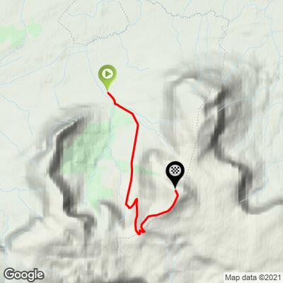
Horseshoe Road to Truskmore Bike Climb - PJAMM Cycling

3.9
FIETS
5 mi
DISTANCE
1,872 ft
GAINED
7 %
AVG. GRADE

FULL CLIMB STATS

Page Contributor(s): Stephen Rockford, Ireland

INTRO

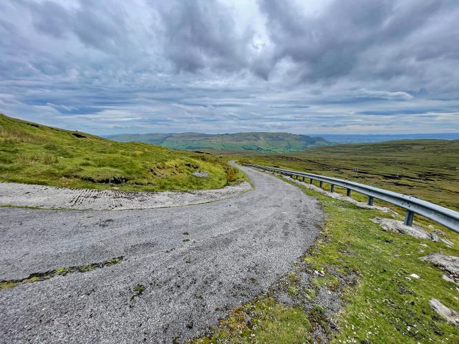
This may be the hardest bike climb in all of Ireland. The hardest part of the climb is the last 4km which is on a closed road up to the antennae. There is a gate which is usually closed to vehicles but you can just lift your bike over and continue up to the top. This section of road is not in great condition with lots of loose chips, sheep droppings and several drop gates.  The scenery from the top is breathtaking.  This is a bucket list Irish Bike Climb - 👍👍

See more details and tools regarding this climb's grade via our interactive Profile Tool.
Roadway:   Once you reach Ballintrillick the road surface deteriorates but is still no problem on a roadbike. 

Traffic:   Minimal for the first half of the climb and none from the midpoint where there is a gate that blocks motor vehicle traffic. 

Parking:   Parking in this area is no problem. For a shorter route focusing solely on just the climb you could park in the villages of Grange or Mullaghmore, both approximately 10km from the start of the climb at Ballintrillick. There are also plenty of parking spaces available in the towns of Bundoran (15km) or Sligo (25km) 
Information Not Available

If you have any information regarding this climb, we'd like to hear from you. Click the CONTRIBUTE button to share your thoughts with us.

Before heading out on any cycling adventure check out our Things to Bring on a Cycling Trip and use our interactive check list to ensure you don't forget anything.
Information Not Available

If you have any information regarding this climb, we'd like to hear from you. Click the CONTRIBUTE button to share your thoughts with us.

ROUTE MAP

MEMBER RATING

Difficulty: Strenuous
2
Road
5
Traffic
5
Scenery

CURRENT WEATHER

PJAMM TRIPS ADVENTURE STARTER BUNDLES

Check out PJAMM Adventure's prepackaged (self-guided) cycling trips. They will help you plan, document and conquer your next adventure.
ALL TRIPS
Browse all of our prepackaged trips and find your next adventure!

NEARBY CLIMBS (0) RADIAL PROXIMITY

FROM
No Climbs Found

MEMBER REVIEWS & COMMENTS

Let us know what you thought of this climb. Signup for our FREE membership to write a review or post a comment.
Already have an account?

Mar 18, 2021
difficulty: Strenuous
scenery: 5
traffic: 5
road: 2
Mar 18, 2021
scenery: 5
traffic: 5
road: 2
Arguably the toughest climb in Ireland. After a couple of km with only a few tricky bits, the real climb starts at the gateway up to the antenna. The road is in poor condition but not too rough for a road bike, just watch out for loose chips and sheep droppings on the descent. The 4km to the top is pretty relentless, it's ramp after ramp making it tough to get a rhythm going, averaging 10% with the toughest part coming at the 3km point where just after a tiny respite the road just pitches right up into a long straight wall nearing 20%. The scenery up here is breathtaking. Views across the sea to Donegal and back the other way across half the province of Connacht. Definitely worth the effort.
ROUTE MAP
PROFILE TOOL
Route Data
S.G. (%)
hide
Segment Data
hide

Climb Profile Not Found
CLIMB SUMMARY

PJAMM Cyclist rides on straight segment of roadway toward hillside in the distance; road is edged by dense shrubbery

Cycling Horseshoe Road, Ireland

Ride 8.1 kilometers gaining 571 meters at 7% average grade.

Tucked away in the northwestern corner of the country, this scenic beauty is the third hardest bike climb in Ireland.  The climb gets its name from Gleniff Horseshoe Loop, a 10 kilometer loop on single lane mountain roads beginning about two kilometers south of Cliffony.  Our climb separates from the horseshoe route at kilometer four, just after a 900 meter descent.  At kilometer four turn left and hop the gate to ride to the television towers four kilometers up the hill at an average grade of 10.2%!

photo collage shows old stone farm buildings, green pastureland and hillsides, green mountain point in distance

This magnificent Irish bike climb is the third hardest in the country.

PJAMM Cyclist rides on narrow country roadway, dense greenery n roadside; sign for Hot Drinks

Climb summary by PJAMM Cycling’s Brad Butterfield:

Our climb starts on a scenic farming road which traces the valley floor between two sheer mountains. Here, enjoy some mild grades. At precisely four kilometers you reach a decision point as our left turn onto the mountain summit road is gated off and clearly marked as private property. We took the risk and hopped the fence. A worker driving down the mountain gave me a friendly wave and nod when I was about halfway up the private road, so I wouldn’t worry too much about repercussions for trespassing, but don’t quote PJAMM Cycling on that.  You do ride at your own risk and cannot rely on our experience in July 2022.  The narrow access road provides stellar views of the lush green Irish hills and the coastline in the far distance. This was one of my favorite climbs that we rode during our time in Ireland and is most definitely worth the trek.

Gleniff Barytes Mill Site at climb's start

Gleniff Barytes Mill Site on the left about 300 meters up the climb from the start.

There are paths, waterfalls, picnic benches, and old abandoned stone structures at this location and it is definitely worth the short detour to explore here at the beginning or end of your ride.

Development and mining at and near this site dates back to 1858. 

Climb summary by PJAMM Cycling’s Tayler Hocket:

Soon after beginning the climb we come to the Gleniff Barytes Mille site which has hiking and historic points that are worth spending time exploring. There are maps, picnic benches, cool old buildings, and a mill. As you roll uphill, the first 1.5 kilometers are made up of gentle rollers.  

Gleniff Horseshoe Valley

Ride through Gleniff Horseshoe Valley for the first kilometers of the climb.

photo collage shows views along the climb; green hillsides, sheep grazing, road in rough shape

At the four kilometer mark you run into a gate clearly marking the service road. It’s a hefty leap to get over that gate and not for the faint of heart, but the workers that we saw didn’t seem to mind. This road is well worth it. Steep, beautiful, and  with magnificent views of the valley and coast.  There is also a really cool change in topography with the top being very rocky and flat. As far as the climb itself, I’d say kilometers 4-8 are very steep, challenging, and full of sheep. Not much respite but you can see the television tower inch closer and closer as you climb.

two gates marked with "No Trespassing" signs

First gate is at the fork at kilometer four (top left) and the second is 400 meters uphill from there (top right).

The gates are clearly marked as no trespassing, although 149 Strava members have made this climb as of July 2022.

aerial drone view shows roadway snaking up green hillsides

photo collage shows rolling green hillsides, tall grasses

Some of the views that make this a hiking and motoring favorite in this part of Ireland.

These are along kilometers 4.6 to 5.2.

Truskmore Mountain on the border of Counties Sligo and Leitrim.  

Ride to the top of Truskmore Mountain on the border of Counties Sligo and Leitrim.

The top is not the best of the views, so definitely stop on the way down to take in the scenery. It is a steep downhill with lots of goats and sheep and the road surface is bumpy so don’t let the speed get out of control. The last few miles after the gate are ripping downhill with a tailwind. We were fortunate to have the weather on our side, on a clear day this would be an epic climb to do. Another climb that is well worth going out of your way for.

Truskmore Transmission site; radio tower at top of climb

The climb finishes at the Truskmore Transmission site.