Rockpile Road Bike Climb - PJAMM Cycling

5.8
PDI
5.6 mi
DISTANCE
1,319 ft
GAINED
4 %
AVG. GRADE

FULL CLIMB STATS

INTRO

This 5.6 mile bike climb is located in CA, USA. The average gradient is 4% and there is a total elevation gain of 1,319 ft, finishing at 1,427 ft.

Use the profile tool, route map, and weather forecast to conquer this cycling climb.

PLAN YOUR ROUTE

We've partnered with Sherpa-Map.com to bring you the best route planning tool. With a PRO Membership you can use this climb as a reference when creating your route.

See more details and tools regarding this climb's grade via our interactive Profile Tool.
Information Not Available

If you have any information regarding this climb, we'd like to hear from you. Click the CONTRIBUTE button to share your thoughts with us.

Information Not Available

If you have any information regarding this climb, we'd like to hear from you. Click the CONTRIBUTE button to share your thoughts with us.

Before heading out on any cycling adventure check out our Things to Bring on a Cycling Trip and use our interactive check list to ensure you don't forget anything.
Information Not Available

If you have any information regarding this climb, we'd like to hear from you. Click the CONTRIBUTE button to share your thoughts with us.

ROUTE MAP

MEMBER RATING

Not Yet Rated
-
Road
-
Traffic
-
Scenery

CURRENT WEATHER

PJAMM TRIPS ADVENTURE STARTER BUNDLES

Check out PJAMM Adventure's prepackaged (self-guided) cycling trips. They will help you plan, document and conquer your next adventure.
ALL TRIPS
Browse all of our prepackaged trips and find your next adventure!
San Francisco Bay Area
United States (CA)
25 ROUTES
30 POIs
ROUTE STATS (TOTAL)
487.9
mi
DISTANCE
65,482
ft
ELEV. GAIN
Sonoma County
United States (CA)
19 ROUTES
39 POIs
ROUTE STATS (TOTAL)
269.3
mi
DISTANCE
41,801
ft
ELEV. GAIN

NEARBY CLIMBS (0) RADIAL PROXIMITY

FROM
No Climbs Found

MEMBER REVIEWS & COMMENTS

Let us know what you thought of this climb. Signup for our FREE membership to write a review or post a comment.
Already have an account?
ROUTE MAP
PROFILE TOOL
Route Data
S.G. (%)
hide
Segment Data
hide
CLIMB SUMMARY

Cycling Rockpile Road - start at the Lake Sonoma Visitor Center

Ride 5.5 miles gaining 1,595’ at 4.3% average grade.

This is a fairly remote northern Sonoma County bike ride that is very safe on a good road with minimal traffic.  The climb can be easily accessed via Healdsburg and the Dry Creek Valley.

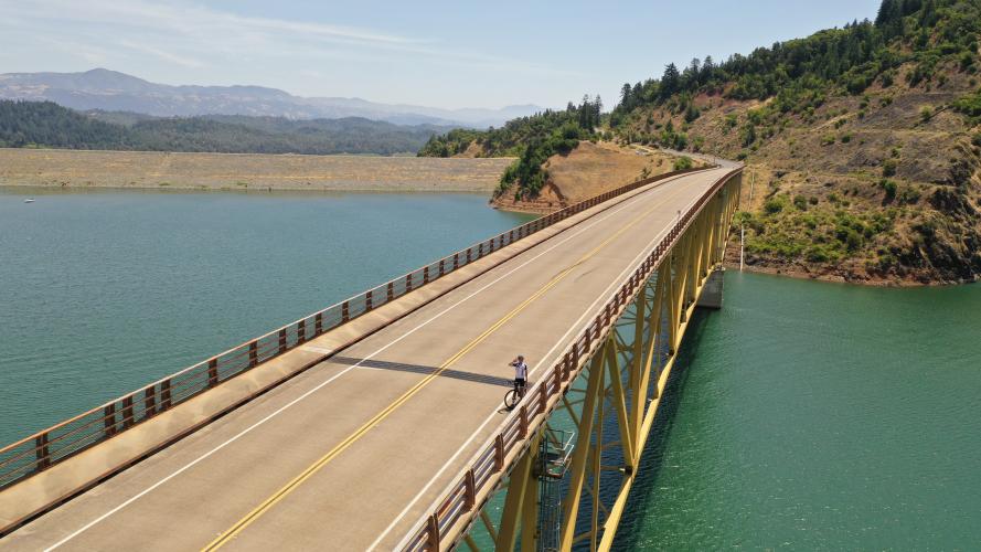
Bridge across Lake Sonoma - mile 2 of the climb.

The approach to this climb is through the spectacular Dry Creek Valley American Viticultural Area (Dry Creek Valley Wine Region and Appellation and up to its sub-region Rockpile AVA.  There are 9,000 acres of vineyards in the Dry Creek Valley - it is one of the most beautiful vineyard regions in the United States. Consider accessing the start of the climb (Lake Sonoma Visitor Center) via West Dry Creek Road instead of the busier and less (but still very) scenic Dry Creek Road.  West Dry Creek Road is on the opposite (southeast of all things) side of the Dry Creek Valley from the Valley’s main drag, Dry Creek Road.

The Rockpile Road bike climb is all about rollers - there are about 4 sets of rollers and 2 significant descents (one .6 miles and another .3) along the climb which has a steepest quarter mile of 10.9% and half mile of 10.5%.

Lake Sonoma boat ramp parking lot - mile 2.4 . . .

. . . where the fun begins!

Warm Springs Dam - 2 mile mark of Rockpile Road climb.

That’s a wrap!