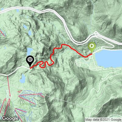
7.3
PDI
3.2 mi
DISTANCE
1,113 ft
GAINED
6.7 %
AVG. GRADE
FULL CLIMB STATS
INTRO
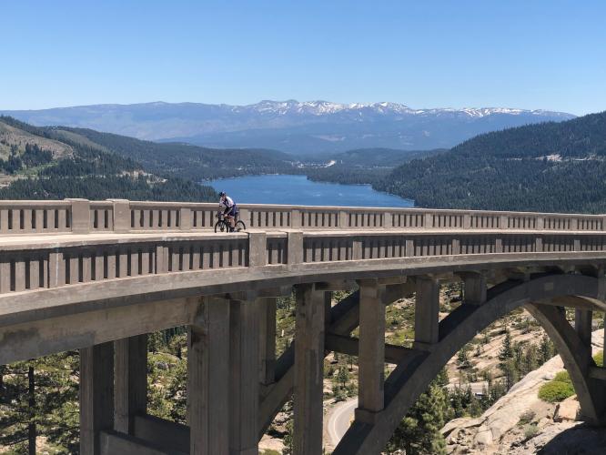
WOW! This is an iconic and gorgeous climb out of Donner Lake near Lake Tahoe, California. We begin in a cool and sweet smelling alpine setting at the western end of Donner Lake by riding up (you’ll know!) Donner Pass Road from its intersection with South Shore Drive. The granite mountains, pine forest and iconic arched Donner Bridge make this a very special bike climb.
PLAN YOUR ROUTE
Arverage grate is 6.7% with 0 descent in 3.2 miles of climbing. The climb gradient on this ride is remarkably consistent - 91% of the climb is at grade 5-10%. The steepest quarter-mile is 7.3% and steepest mile is 7.1%.
Roadway: This road is two lanes with a center stripe and shoulder wide enough to ride in, although the shoulder is often covered with sand, eliminating it as a riding option. The roadway surface is good, but with some cracks.
Traffic: Light.
Parking: At the West End Beach parking lot on South Shore Drive just off Donner Pass Road at climb start - Map; Street View.
Provisions: At Sticks Market 2.3 miles from climb start - Map.
Before heading out on any cycling adventure check out our Things to Bring on a Cycling Trip and use our interactive check list to ensure you don't forget anything.
Stay in Tahoe City on Lake Tahoe and ride to the climb via Highway 89 (there is a bike trail for about half that ride (to Squaw Valley Road; Map), or ride from Truckee if you are staying there - four miles (Map).
See our Lake Tahoe climb area page for detailed information on all the great climbs in the Lake Tahoe area.
Use the “Routes in Area” button on the menu bar above to see other bike climbs in this area.
ROUTE MAP
MEMBER RATING
CURRENT WEATHER
PJAMM TRIPS ADVENTURE STARTER BUNDLES
Check out PJAMM Adventure's prepackaged (self-guided) cycling trips. They will help you plan, document and conquer your next adventure.
NEARBY CLIMBS (0) RADIAL PROXIMITY
FROM No Climbs Found
MEMBER REVIEWS & COMMENTS
Let us know what you thought of this climb. Signup for our FREE membership to write a review or post a comment.
Already have an account?
LOG IN HERE
scottmckinney
This climb is arguably THE most scenic climb in the entire Tahoe basin. It's also chalk full of history. You'll see Donner Lake, granite peaks, the transcontinental railroad (abandoned track, tunnels and snow sheds), China Wall, rock climbing walls (school rock and others). The climb itself follows Hwy 40, the original transcontinental highway. You'll pass the Dutch-Flat wagon road, signs indicating petroglyphs, and more. Just at the top, you'll pass the Pacific Crest Trail. The only thing better than the climb is the newly paved (2022) descent -- you'll zoom over the iconic curved bridge framing the lake and valley below.
sfsf01
Little video of the climb: https://youtu.be/VOEL-tXtLbg
")


")
")
")
")
")
")
 - Donner Bridge")
")
")
