Little Cottonwood Canyon Bike Climb - PJAMM Cycling

28.8
PDI
10.5 mi
DISTANCE
3,998 ft
GAINED
7.2 %
AVG. GRADE

FULL CLIMB STATS

Page Contributor(s): Bruce Hamilton, La Quinta, CA, USA; Stacy Topping, Tacoma, WA, USA

INTRO

"Little Cottonwood Canyon is a very difficult and scenic climb just south of Salt Lake City into the Wasatch Mountains with a steep walled canyon. Called the most dangerous road in the U.S. (avalanches) the steepest section is over its bottom half through gentle turns along the north side of the drainage. Ski areas soon appear and the grade eases as you climb higher. The ride ends at a parking area within a scenic bowl just above the Alta Ski Resort where the pavement turns to dirt. The descent of Little Cottonwood is one of the quickest as its mostly gentle curves funnel you down the hill. There is an annual hill climb race on its slopes as well." (This quote is presented with the approval of John Summerson, from his book, 50 Climbs (by Bike) in Utah, pg. 92.)

PLAN YOUR ROUTE

We've partnered with Sherpa-Map.com to bring you the best route planning tool. With a PRO Membership you can use this climb as a reference when creating your route.
7.2% average grade to 10 full miles makes this a challenging bike climb.  The steepest quarter-mile of the climb is 11.7% and the steepest continuous mile is 10%.  14% of the climb is at 10% grade or greater. 
Roadway:  The paved portion of the road was in excellent shape as of 2019.  The last two miles are on dirt which is easily manageable by road bike. 

Traffic:  Little Cottonwood Canyon can be a moderately busy roadway and traffic does pass by at 50 mph or so on stretches of the road.  If you are traffic averse you may want to reconsider this climb.  Traffic does thin out substantially as we climb and the second half of the climb is much less troubling than the first. 

Parking:  Free parking at the Little Cottonwood Parking Lot at the beginning of the climb.  MapStreet View
Gear:  You do not need a gravel or mountain bike for this climb, in spite of the dirt road for the last two miles.

Clothing:  You are traveling to high altitude (9,400') so consult the PJAMM Weather Tool for the forecast at the finish of your climb around the time you expect to finish. 

Food/Drink:  There are facilities at both Snowbird Resort and Alta that should be open for you to get something to eat or drink if you need it. 
Before heading out on any cycling adventure check out our Things to Bring on a Cycling Trip and use our interactive check list to ensure you don't forget anything.
Although it is a bit of a trek to get to Little Cottonwood from Park City, we prefer that town as our cycling hub when riding in and around the Salt Lake City-Park City area.  See PJAMM's climb area - Park City, UT.

If you are staying in Park City there are many great resorts and hotels to choose from.  If your stay is going to be longer term, there are several condos and homes to rent in this popular ski area.   

There are some closer hotel options near the start of this climb too.  

ROUTE MAP

MEMBER RATING

Difficulty: Strenuous
4.5
Road
3.5
Traffic
4.5
Scenery

CURRENT WEATHER

PJAMM TRIPS ADVENTURE STARTER BUNDLES

Check out PJAMM Adventure's prepackaged (self-guided) cycling trips. They will help you plan, document and conquer your next adventure.
ALL TRIPS
Browse all of our prepackaged trips and find your next adventure!
The American Southwest
United States (AZ,NM,UT)
18 ROUTES
27 POIs
ROUTE STATS (TOTAL)
215.4
mi
DISTANCE
34,866
ft
ELEV. GAIN
Utah: Moab, Arches & Canyonlands
United States (UT)
19 ROUTES
21 POIs
ROUTE STATS (TOTAL)
325.3
mi
DISTANCE
32,871
ft
ELEV. GAIN
Utah: Zion National Park
United States (UT)
20 ROUTES
32 POIs
ROUTE STATS (TOTAL)
256.5
mi
DISTANCE
39,649
ft
ELEV. GAIN

NEARBY CLIMBS (0) RADIAL PROXIMITY

FROM
No Climbs Found

MEMBER REVIEWS & COMMENTS

Let us know what you thought of this climb. Signup for our FREE membership to write a review or post a comment.
Already have an account?

Jul 9, 2024
difficulty: Strenuous
scenery: 4
traffic: 4
road: 5
Jul 9, 2024
scenery: 4
traffic: 4
road: 5
The roads and scenery in LCC are great. Traffic on a Tuesday morning in July was light and the bike lane on the uphill side provided plenty of room. The descent was very smooth and only a couple of curves required feathering the brakes (my bike has rim brakes). I think the lower humidity levels (if you’re used to the sauna like conditions of the SE as I am) also made this easier than I was led to expect. As an additional FYI, I rode this on my first full day in SLC after driving a U-Haul from NC to help my son move to Utah so the legs and lungs were not their freshest.
May 19, 2021
difficulty: Strenuous
scenery: 5
traffic: 3
road: 4
May 19, 2021
scenery: 5
traffic: 3
road: 4
My favorite canyon to climb in SLC for the scenery but you have to work for that view as it is definitely the hardest of the SLC canyons. Super fun descent.
ROUTE MAP
PROFILE TOOL
Route Data
S.G. (%)
hide
Segment Data
hide
CLIMB SUMMARY

Cycling Utah’s Little Cottonwood Canyon -- #29 US Bike Climb.

Ride 10.5 miles gaining 4,020’ to 9,380’ at 7.2% average grade. 

Climb summary by PJAMM’s John Johnson.

Biking or skiing, there aren’t many spots better than the Little Cottonwood Canyon bike climb in Utah.  During the winter, two of the premiere ski resorts in the country, Alta and Snowbird, are accessed via Little Cottonwood Canyon. 

Before heading to Utah on your Little Cottonwood Canyon cycling adventure, be sure to rely on our list of Things to Bring on a Cycling Trip, and use our interactive checklist to ensure you don't forget anything.

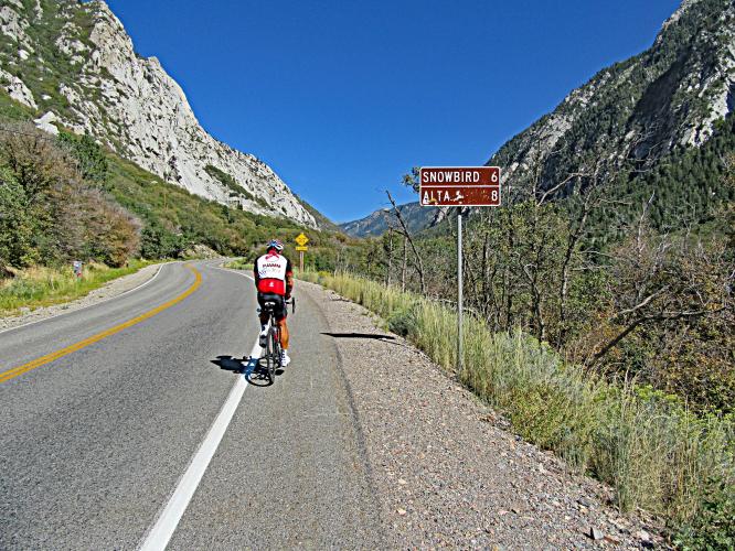
Beginning of climb by bike up Little Cottonwood Canyon - street signs

The climb begins southeast of Salt Lake City on Highway 210.

Ski run sign at the finish of the Little Cottonwood Canyon bicycle ride.

Our climb is in the Wasatch National Forest (1906; 86,440 acres)

   Cyclist with bike at top of Little Cottonwood Canyon climb by bike.

The bike climb ends at the top of Alta’s Sunnyside ski lift.

During the spring and summer, this is a favorite climb for cyclists who live in, or travel to, the Salt Lake City area.  One of the great advantages for climbers in this part of the country is quick access to four high-quality ascents within 20 miles of one another (Little Cottonwood, US #15 Guardsman, #37 Big Cottonwood, and #53 Empire Pass from Midway, or unrated Empire climb from Park City) and only 24 miles from Salt Lake City International Airport.  We flew in from Northern California on a weekday morning and flew out the next evening and were able to get Powder, Guardsman, Big and Little Cottonwood and Empire in during that two-day, one-night trip.  

Cyclist with bike at top of Little Cottonwood Canyon climb by bike.

Cyclist with bike at top of Little Cottonwood Canyon climb by bike.

Cyclist with bike at top of Little Cottonwood Canyon climb by bike.

Snowbird Ski Resort at mile 6.5

Cyclist with bike at top of Little Cottonwood Canyon climb by bike.

You can finish the climb at Alta Ski Resort (8.3 miles, 3,300' gained at 7.6% average grade, FIETS index of 9.29) . . .

Ski run sign at the finish of the Little Cottonwood Canyon bicycle ride.

Ski run sign at the finish of the Little Cottonwood Canyon bicycle ride.

Alta Ski Resort parking lot at mile 8.3.

. . . or take it to the top (another 1.9 miles at 5.9%)!  Continue through the Alta parking lot to Albion Basin Road where the road soon turns to gravel (manageable on a road bike -- we used 28mm tires) for the last couple miles at a 5.6% average grade, ending near the top of Alta's Sunnyside ski lift.

Ski run sign at the finish of the Little Cottonwood Canyon bicycle ride.

1.9 more to go . . .

Ski run sign at the finish of the Little Cottonwood Canyon bicycle ride.

Bruce and Stacy at the gate - May 2019.

Ski run sign at the finish of the Little Cottonwood Canyon bicycle ride.

 The End.

The Little Cottonwood Canyon bike climb is “Little” because it is shorter and narrower than Big Cottonwood Canyon, which is four miles to the north.  However, the two are equals in regards to surroundings and raw beauty.  

​​Roadway and Traffic Report:  As you can readily see from our videos, the first six miles of this climb is a highway and cars do zip by at a good clip, although there is a very good shoulder/bike lane for most of the climb.  Miles 6-8 are past Snowbird and Alta and the final two miles are on a rough paved and then hard packed dirt/gravel road at 5.6% which is rideable on a road bike without difficulty.

Steepest ¼ miles begins at mile 3.6 (11.7%) and steepest mile at mile 3 (9.9%).