![Cycling Chew Road - England Another 100 Greatest Cycling Climbs; gravel roadway surrounded by rolling green hills]()
Cycling Chew Road - England’s seventh hardest bike climb
Ride 1.6 miles gaining 911’ at 10.7% average grade.
This is a challenging and fun climb in the Northwest region of England, about 20 kilometers northeast of Manchester. This climb is quite steep which is what gets a 1.6 mile climb into England’s Top 10 Hardest Bike Climbs - there is a 15% quarter-mile along the route, and the final tenth of a mile averages 16.6%.
![Cycling Chew Road - England photo collage shows aerial view of roadway stretching through green hills]()
This is a very fun climb.
![Cycling Chew Road - England bike parked on bridge at Dovestone Reservoir]()
Climb begins just past the southeastern tip of Dovestone Reservoir.
Chew Road begins in a very popular recreation area surrounding a large lake. There is paid parking available here, but it can be tough to find as it is a very highly trafficked destination. I opted to park in the town of Greenfield, about two miles from the start point of the climb. Parking was free and easy to find and the ride from Greenfield is a nice add-on to the climb anyway. The Chew Road climb is closed to public motor traffic, so it’ll be just you and the hikers on the road. The pavement quality wanes from very poor to gravel, but is doable on a standard road bike. Chew Road winds up the side of a mountain with views of the lake below showcasing some of the best scenery available in England. The finish is at another reservoir - this is the only lake to lake climb we encountered in documenting the most epic and the hardest bike climbs in the UK.
![Cycling Chew Road - England parking at climb's start, Dovestone Reservoir]()
Parking on the southwestern end of Dovestone Reservoir just before the start of the climb.
![Cycling Chew Road - England photo collage, Dovestone Reservoir; geese in lake, green hills, gravel road]()
Pass Dovestone Reservoir on your way to the start of the climb.
![Cycling Chew Road - England photo collage shows green hills and gravel roadway]()
The road is closed to vehicles but you do have to contend with a bit of gravel.
![Cycling Chew Road - England photo collage shows rock formations on hillside at mile 1.4]()
Great rock formations around mile 1.4.
![Cycling Chew Road - England aerial drone view of the final leg of climb; green hillsides with road stretching through]()
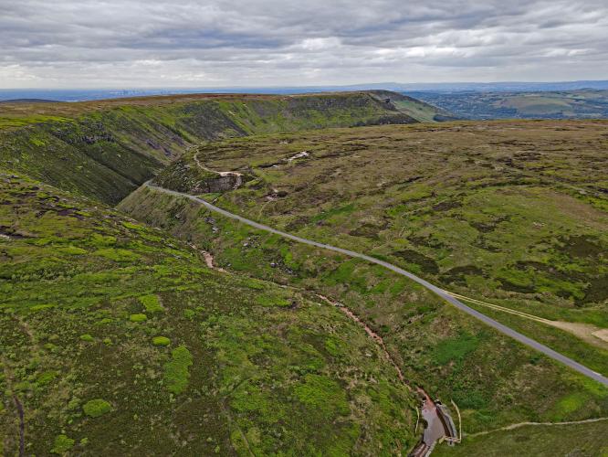
You can see the finish area as you climb the last portion of this climb if you know what you're looking for. The photo above left is along the final very steep segment.
![Cycling Chew Road - England aerial photos of final leg of climb, green hillsides with gravel roadway]()
The top two photos above are aerials of the final segment leading to the finish. The bottom photo above is leading to the sharp left turn and final stretch to the top.
![Cycling Chew Road - England PJAMM Cyclist stands next to climb finish and waves]()
Climb’s finish.
![Cycling Chew Road - England aerial drone view of Chew Reservoir]()
Climb ends at Chew Reservoir.
![]()
That’s a wrap!

 We've partnered with Sherpa-Map.com to bring you the best route planning tool. With a PRO Membership you can use this climb as a reference when creating your route.

