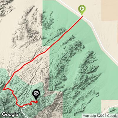
Lee Canyon + Hwy 158 Bike Climb - PJAMM Cycling

10.4
FIETS
16.3 mi
DISTANCE
5,034 ft
GAINED
5.8 %
AVG. GRADE

FULL CLIMB STATS

Page Contributor(s): Ron Hawks, Las Vegas, Nevada, USA

INTRO

"Another very difficult climb, this hill shares its start with beyond category Lee Canyon. Ride the long approach up Route 156 with its distant views and solid grade until around mile 14 when you turn left onto Nevada 158. Very soon you encounter increased grade and a more twisty route as you head along the shoulder of the massive mountain ridge. Long views are to your left and more trees appear as you gain altitude. After just over a half mile on 158 the grade eases a bit and you pass the 8,000 feet elevation mark (signed). Soon the grade eases further and just over two miles from the junction with Lee Canyon the listed climb ends at an unmarked pass at over 8,300 feet..." (This quote is presented with the approval of John Summerson, from his book, The Complete Guide to Climbing (by Bike), 2nd Edition, pg. 198.)

See more details and tools regarding this climb's grade via our interactive Profile Tool.
Information Not Available

If you have any information regarding this climb, we'd like to hear from you. Click the CONTRIBUTE button to share your thoughts with us.

Information Not Available

If you have any information regarding this climb, we'd like to hear from you. Click the CONTRIBUTE button to share your thoughts with us.

Before heading out on any cycling adventure check out our Things to Bring on a Cycling Trip and use our interactive check list to ensure you don't forget anything.
We stayed in Las Vegas when we did these climbs and drove the 18 miles from Vegas to this climb for our long riding day.

ROUTE MAP

MEMBER RATING

Not Yet Rated
-
Road
-
Traffic
-
Scenery

CURRENT WEATHER

PJAMM TRIPS ADVENTURE STARTER BUNDLES

Check out PJAMM Adventure's prepackaged (self-guided) cycling trips. They will help you plan, document and conquer your next adventure.
ALL TRIPS
Browse all of our prepackaged trips and find your next adventure!
Death Valley
United States (CA)
21 ROUTES
34 POIs
ROUTE STATS (TOTAL)
553.3
mi
DISTANCE
55,125
ft
ELEV. GAIN
Lake Tahoe
United States (CA,NV)
18 ROUTES
32 POIs
ROUTE STATS (TOTAL)
245.7
mi
DISTANCE
35,240
ft
ELEV. GAIN

NEARBY CLIMBS (0) RADIAL PROXIMITY

FROM
No Climbs Found

MEMBER REVIEWS & COMMENTS

Let us know what you thought of this climb. Signup for our FREE membership to write a review or post a comment.
Already have an account?
ROUTE MAP
PROFILE TOOL
Route Data
S.G. (%)
hide
Segment Data
hide

Climb Profile Not Found
CLIMB SUMMARY

Cycling Lee Canyon + Hwy 158 (#3 Nevada/#35 USA)

Ride 16.3 miles gaining 4,986’ at 5.7% average grade.

Hwy 158 is the grade cut into the mountain center-left of photo

Hwy 156-158 is a Top 50 U.S. Climb which begins in a fairly desolate and desert-like setting about 30 miles northwest of Las Vegas.

IMG_5548.JPG

 This climb can be extremely hot and probably should be avoided between June and August when the average high temperature ranges from 99 to 104 degrees.   The first 11 miles are through high desert landscape with many Joshua Trees, which turns gradually to pine and fir forest beginning around mile 12.  

IMG_5551.JPG 

By the time we top 8,000', we are in a completely different climate zone made up of pine forest and scenic mountain formations.  The Highway 158 portion of this climb begins by turning left off Highway 156 onto 158 at about the 14.1 miles mark.  From miles 0-14.1 we gain 4,460' at 5.9% average grade.  The final 2.2 miles on Highway 158 are at 4.5% gaining 498'

Looking back to the turn off (we actually turn left onto 158 on the ascent)  

The climb is fairly steady, between 4-7%, and with very few higher extended grades throughout. This ride can be done in conjunction with 3 other climbs  in the immediate area (#22 Hwy 156 which shares its first 14 miles with they Hwy 156 climb, #49 Hwy 157-158 and ​​Hwy #66 Hwy 157). Be careful if doing this ride without support as the only provisions are likely to be at the Mt Charleston Resort at the end of Hwy 157 - support is highly recommended for any effort involving Lee and​ Kyle Canyons in the same ride.

Desert View Overlook - Mile 15.6

Magnificent views from the overlook.


Finish - High point at 8,682’

Roadway Surface and Traffic: This climb is primarily along a Nevada state highway (156) which does not have a shoulder or bike lane to speak of, yet traffic is minimal, making the ride much less nerve-wracking than riding on the busier state highways.  The 2.2 miles on Hwy 158 are wonderful, with minimal traffic and excellent views.  The roadway surface is excellent throughout.

Access to full Climb Summary requires a PJAMM Cycling PRO Membership!

It takes less than a minute to sign up & with your PRO membership you can:
  • Rate climbs, post comments and share your experiences on any of our climb pages
  • Create bucket lists of climbs & mark the dates you complete them
  • Weather data for all climbs - Start & Finish
  • Upload photos to your member page to customize your PJAMM Cycling experience
  • Utilize all of our interactive tools - Profile & Routes in Area
  • Download climb route .gpx files
LEARN MORE
SIGN UP

Already have an account? LOG IN HERE