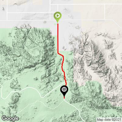
Pinto Basin Road North Bike Climb - PJAMM Cycling

2.2
FIETS
10.3 mi
DISTANCE
1,898 ft
GAINED
3.4 %
AVG. GRADE

FULL CLIMB STATS

Page Contributor(s): Bruce Hamilton, La Quinta, CA, USA

INTRO

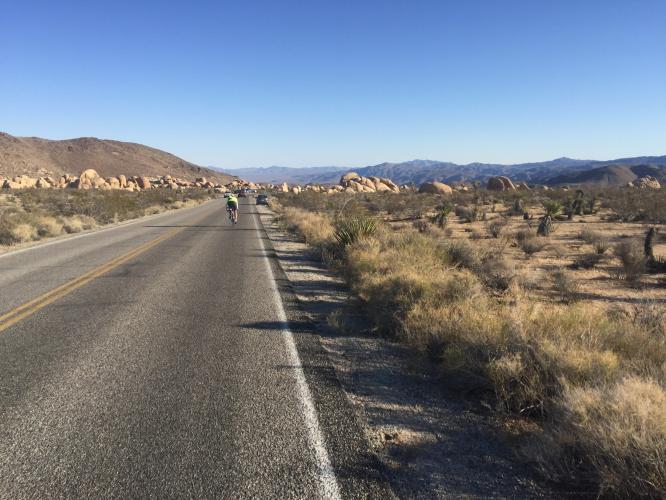
This 10.3 mile bike climb is located in CA, USA. The average gradient is 3.4% and there is a total elevation gain of 1,898 ft, finishing at 3,874 ft.

Use the profile tool, route map, and weather forecast to conquer this cycling climb.

See more details and tools regarding this climb's grade via our interactive Profile Tool.
Information Not Available

If you have any information regarding this climb, we'd like to hear from you. Click the CONTRIBUTE button to share your thoughts with us.

Information Not Available

If you have any information regarding this climb, we'd like to hear from you. Click the CONTRIBUTE button to share your thoughts with us.

Before heading out on any cycling adventure check out our Things to Bring on a Cycling Trip and use our interactive check list to ensure you don't forget anything.
Information Not Available

If you have any information regarding this climb, we'd like to hear from you. Click the CONTRIBUTE button to share your thoughts with us.

ROUTE MAP

MEMBER RATING

Difficulty: Moderate
4
Road
4
Traffic
2
Scenery

CURRENT WEATHER

PJAMM TRIPS ADVENTURE STARTER BUNDLES

Check out PJAMM Adventure's prepackaged (self-guided) cycling trips. They will help you plan, document and conquer your next adventure.
ALL TRIPS
Browse all of our prepackaged trips and find your next adventure!

NEARBY CLIMBS (0) RADIAL PROXIMITY

FROM
No Climbs Found

MEMBER REVIEWS & COMMENTS

Let us know what you thought of this climb. Signup for our FREE membership to write a review or post a comment.
Already have an account?

May 28, 2022
difficulty: Moderate
scenery: 2
traffic: 4
road: 4
May 28, 2022
scenery: 2
traffic: 4
road: 4
Good ride to see the other side of Joshua Tree. I was happy to do the ride because the landscape was so boring I didn't feel compelled to try and hike in the area. Traffic is not as plentiful on the side of the park versus the main park road.
ROUTE MAP
PROFILE TOOL
Route Data
S.G. (%)
hide
Segment Data
hide

Climb Profile Not Found
CLIMB SUMMARY

Joshua Tree National Park is 1 of 8 national parks in California and is the 53rd established (1994) making it one of the newer (Yellowstone #1 in 1872) national parks.  The park is in the mid-range for size (790,636 acres) and visitors (2,942,382 (2018).

Cycling is welcome in the park and there are actually 3 camp sites designated exclusively for cyclists (Joshua Tree NP Cycling page).

Summaries by PJAMM friend and contributor Bruce Hamilton, La Quinta, CA, USA.

CYCLING PINTO BASIN ROAD SOUTH

This climb starts at the low point in the center of the park – you’ll know you’re there when you see the sign and cross the Fried Liver Wash. This ride is best approached from the south entrance to the park and we often ride it from just outside the park. It is hot in summer months and starting early is highly recommended. I’ve done it several times starting before sunrise under a full moon and then continuing as the sky turns orange through the dawn and the sun rises.

This is a fantastic time to ride this course – I have done it where I did not see a single car for four hours. The pavement is good and the traffic light and this is not a difficult climb – averaging about 4% over the 10 miles until you get to the crest.

CYCLING PINTO BASIN ROAD NORTH

There are three entrances to Joshua Tree National Park and this climb begins at the northeast entrance, just at the edge of the town of 29 Palms (home of Marine Corps Air Ground Combat Center; population ~26,000 2018). The climb is not difficult but there is no warmup as you are immediately going uphill as you enter the park.

The first five miles or so is pretty steady and the second half of this climb has some softer grades. Don’t forget to bring your park pass (or $15.00 for cyclists as of 2019)  – the fee station is just a few miles from town and it’s a long downhill and re-climb to go back and get it. This ride can be done as an out and back or it can be part of a ride all the way through the park. The climb is almost finished when you come to the junction that will take you either further south through the park or to the town of Joshua Tree. To finish the climb, turn left at the junction and continue to the top of the crest. This can easily be combined with Pinto Basin South by going over the crest and continuing down for about 11 miles to the Fried Liver Wash. Turn around there to begin the Pinto Basin South climb back to the crest.

There is no water along this route and it can be hot and desolate. It is spectacular, however, and highly recommended.

Getting around in Joshua Tree National Park (other than by bike and car):  Free shuttle service for the northern section as of 2019 under an experimental plan that allows free access to the park for shuttle riders.

 No water along these routes so take care if it’s warm.

USClimbateData.com