6.3
PDI
5.7 mi
DISTANCE
1,307 ft
GAINED
4.3 %
AVG. GRADE
FULL CLIMB STATS
INTRO
This 5.7 mile bike climb is located in UT, USA. The average gradient is 4.3% and there is a total elevation gain of 1,307 ft, finishing at 6,000 ft.
Use the profile tool, route map, and weather forecast to conquer this cycling climb.
Use the profile tool, route map, and weather forecast to conquer this cycling climb.
PLAN YOUR ROUTE
This climb averages 0%. The steepest quarter mile of this climb is 0%. NaN miles of the climb is at or above 10% grade. The gradient on this climb is broken down as follows:
See more details and tools regarding this climb's grade via our interactive Profile Tool.
See more details and tools regarding this climb's grade via our interactive Profile Tool.
Information Not Available
If you have any information regarding this climb, we'd like to hear from you. Click the CONTRIBUTE button to share your thoughts with us.
Information Not Available
If you have any information regarding this climb, we'd like to hear from you. Click the CONTRIBUTE button to share your thoughts with us.
Before heading out on any cycling adventure check out our Things to Bring on a Cycling Trip and use our interactive check list to ensure you don't forget anything.
Information Not Available
If you have any information regarding this climb, we'd like to hear from you. Click the CONTRIBUTE button to share your thoughts with us.
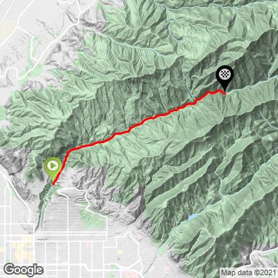
ROUTE MAP
MEMBER RATING
CURRENT WEATHER
PJAMM TRIPS ADVENTURE STARTER BUNDLES
Check out PJAMM Adventure's prepackaged (self-guided) cycling trips. They will help you plan, document and conquer your next adventure.
NEARBY CLIMBS (0) RADIAL PROXIMITY
FROM No Climbs Found
MEMBER REVIEWS & COMMENTS
Let us know what you thought of this climb. Signup for our FREE membership to write a review or post a comment.
Already have an account?
LOG IN HERE
akbean
Short , moderate climb with some steeper sections up top. Closed to cars on odd days, so you'll only have to contend with pedestrians and other cyclists. Pedestrians thin out past mile 1 or 2. The road narrows after mile 3 (past the water treatment plant) and plunges you deep into alpine forest. Really pretty!
HakenBaconator
Not a terribly difficult climb, but you will get a little kick at the end. The road gets pretty narrow and crappy towards the end, which isn't a problem going up so much as coming back down. The road is open to cars on even days and to cyclists on odd days, which means there is NO traffic, just a lot of pedestrians and cyclists to watch out for. Not incredible views, but the canyon definitely doesn't look ugly. This would be a good climb if you don't have a ton of time to spare, but want to get a decent workout in.