13.7
PDI
9 mi
DISTANCE
2,463 ft
GAINED
5.2 %
AVG. GRADE
FULL CLIMB STATS
Page Contributor(s): Bruce Hamilton and Stacy Topping, Midway, Utah.
INTRO
"The climb of Millcreek Canyon is a moderate grade climb very close to Salt Lake City. It contains several flats along the way for recover which lessen its average grade. The 2nd half contains more shade and the final few miles are closed to vehicles although it can still be quite busy on weekends. The pavement ends at its summit." (This quote is presented with the approval of John Summerson, from his book, 50 Climbs (by Bike) in Utah, pg. 88.)
PLAN YOUR ROUTE
Average grade is 5.3% with 2,480' gained with 0 descent. The climb is fairly steady throughout with 44% at 0-5% grade and 54% at 5-10%. The steepest quarter-mile is 8.8%.
See more details and tools regarding this climb's grade via the “Profile Tool” button.
Information Not Available
If you have any information regarding this climb, we'd like to hear from you. Click the CONTRIBUTE button to share your thoughts with us.
Information Not Available
If you have any information regarding this climb, we'd like to hear from you. Click the CONTRIBUTE button to share your thoughts with us.
Before heading out on any cycling adventure check out our Things to Bring on a Cycling Trip and use our interactive check list to ensure you don't forget anything.
Use the “Routes in Area” button on the menu bar above to see other bike climbs in this area.
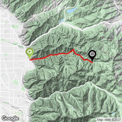
ROUTE MAP
MEMBER RATING
CURRENT WEATHER
PJAMM TRIPS ADVENTURE STARTER BUNDLES
Check out PJAMM Adventure's prepackaged (self-guided) cycling trips. They will help you plan, document and conquer your next adventure.
NEARBY CLIMBS (0) RADIAL PROXIMITY
FROM No Climbs Found
MEMBER REVIEWS & COMMENTS
Let us know what you thought of this climb. Signup for our FREE membership to write a review or post a comment.
Already have an account?
LOG IN HERE
akbean
Really beautiful climb through the forest. Some challenging sections, but enough flats / false flats to give you a break. Up past the winter gate (so called because it is closed to cars in the winter) the road narrows significantly and there is no shoulder. Traffic can be heavy, so be alert. The road quality isn't great, so keep an eye out for potholes on the descent.