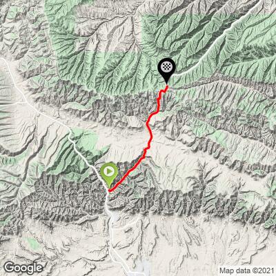
Indian Canyon South Bike Climb - PJAMM Cycling

14.7
PDI
15.1 mi
DISTANCE
3,073 ft
GAINED
3.7 %
AVG. GRADE

FULL CLIMB STATS

Page Contributor(s): Bruce Hamilton and Stacy Topping, Midway, Utah

INTRO

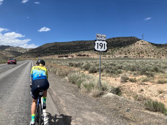
Indian Canyon South offers a scenic 15.1 mile climb beginning just north of Price, Utah, gaining over 3,000 feet in elevation as it winds through dramatic canyon landscapes to a summit above 9,000 feet. Riders enjoy mostly gradual grades, with the steepest sections and best vistas in the final miles.

PLAN YOUR ROUTE

We've partnered with Sherpa-Map.com to bring you the best route planning tool. With a PRO Membership you can use this climb as a reference when creating your route.

See more details and tools regarding this climb's grade via our interactive Profile Tool.
Information Not Available

If you have any information regarding this climb, we'd like to hear from you. Click the CONTRIBUTE button to share your thoughts with us.

Information Not Available

If you have any information regarding this climb, we'd like to hear from you. Click the CONTRIBUTE button to share your thoughts with us.

Before heading out on any cycling adventure check out our Things to Bring on a Cycling Trip and use our interactive check list to ensure you don't forget anything.
Information Not Available

If you have any information regarding this climb, we'd like to hear from you. Click the CONTRIBUTE button to share your thoughts with us.

ROUTE MAP

MEMBER RATING

Not Yet Rated
-
Road
-
Traffic
-
Scenery

CURRENT WEATHER

PJAMM TRIPS ADVENTURE STARTER BUNDLES

Check out PJAMM Adventure's prepackaged (self-guided) cycling trips. They will help you plan, document and conquer your next adventure.
ALL TRIPS
Browse all of our prepackaged trips and find your next adventure!
The American Southwest
United States (AZ,NM,UT)
18 ROUTES
27 POIs
ROUTE STATS (TOTAL)
215.4
mi
DISTANCE
34,866
ft
ELEV. GAIN
Utah: Moab, Arches & Canyonlands
United States (UT)
19 ROUTES
21 POIs
ROUTE STATS (TOTAL)
325.3
mi
DISTANCE
32,871
ft
ELEV. GAIN
Utah: Zion National Park
United States (UT)
20 ROUTES
32 POIs
ROUTE STATS (TOTAL)
256.5
mi
DISTANCE
39,649
ft
ELEV. GAIN

NEARBY CLIMBS (0) RADIAL PROXIMITY

FROM
No Climbs Found

MEMBER REVIEWS & COMMENTS

Let us know what you thought of this climb. Signup for our FREE membership to write a review or post a comment.
Already have an account?
ROUTE MAP
PROFILE TOOL
Route Data
S.G. (%)
hide
Segment Data
hide
CLIMB SUMMARY

Cycling Indian Canyon South

Ride 15.1 miles gaining 3,073’ at 3.7% average grade.

Indian Canyon is part of the Indian Canyon Scenic Byway, a route known for its colorful rock formations, diverse forests, and wildlife such as elk and deer. The byway passes through Ashley National Forest and reaches its peak at Indian Creek Pass, around 9,100 feet in elevation, offering magnificent views of forested slopes and deep, rugged canyons. The area is particularly beautiful in the autumn when the foliage is at its most vibrant. The canyon also holds historical significance, with nearby sites featuring ancient Native American rock art and remnants of early settler trails

Climb summary by PJAMM Ambassador Bruce Hamilton.

The Indian Canyon South climb begins a few miles north of the town of Price, Utah. If you are traveling from Price on Highway 6, turn right onto Highway 191 and park in the lot immediately on the right after the turn. From this parking area, you can see the river and the bridge marking the start of the climb. Traffic on this route is typically lighter than expected. The climb itself is gradual for most of the way, with the majority of the elevation gain occurring in the last five miles. Be prepared for hot conditions in the summer, as there is no water or commercial services along the route. The prevailing wind is from the southwest, which can provide a helpful tailwind, as experienced on our ride. As you approach the summit—just over 9,000 feet—you are rewarded with expansive vistas.

Thank you Bruce Hamilton and Stacy Topping!!