Hwy 44 North (Flaming Gorge Climb) Bike Climb - PJAMM Cycling

9.4
PDI
4.1 mi
DISTANCE
1,423 ft
GAINED
6.6 %
AVG. GRADE

FULL CLIMB STATS

Page Contributor(s): Bruce Hamilton and Stacy Topping, Midway, Utah

INTRO

This 4.1 mile bike climb is located in UT, USA. The average gradient is 6.6% and there is a total elevation gain of 1,423 ft, finishing at 7,584 ft.

Use the profile tool, route map, and weather forecast to conquer this cycling climb.

See more details and tools regarding this climb's grade via our interactive Profile Tool.
Information Not Available

If you have any information regarding this climb, we'd like to hear from you. Click the CONTRIBUTE button to share your thoughts with us.

Information Not Available

If you have any information regarding this climb, we'd like to hear from you. Click the CONTRIBUTE button to share your thoughts with us.

Before heading out on any cycling adventure check out our Things to Bring on a Cycling Trip and use our interactive check list to ensure you don't forget anything.
Information Not Available

If you have any information regarding this climb, we'd like to hear from you. Click the CONTRIBUTE button to share your thoughts with us.

ROUTE MAP

MEMBER RATING

Not Yet Rated
-
Road
-
Traffic
-
Scenery

CURRENT WEATHER

PJAMM TRIPS ADVENTURE STARTER BUNDLES

Check out PJAMM Adventure's prepackaged (self-guided) cycling trips. They will help you plan, document and conquer your next adventure.
ALL TRIPS
Browse all of our prepackaged trips and find your next adventure!
The American Southwest
United States (AZ,NM,UT)
18 ROUTES
27 POIs
ROUTE STATS (TOTAL)
215.4
mi
DISTANCE
34,866
ft
ELEV. GAIN
Utah: Moab, Arches & Canyonlands
United States (UT)
19 ROUTES
21 POIs
ROUTE STATS (TOTAL)
325.3
mi
DISTANCE
32,871
ft
ELEV. GAIN
Utah: Zion National Park
United States (UT)
20 ROUTES
32 POIs
ROUTE STATS (TOTAL)
256.5
mi
DISTANCE
39,649
ft
ELEV. GAIN

NEARBY CLIMBS (0) RADIAL PROXIMITY

FROM
No Climbs Found

MEMBER REVIEWS & COMMENTS

Let us know what you thought of this climb. Signup for our FREE membership to write a review or post a comment.
Already have an account?
ROUTE MAP
PROFILE TOOL
Route Data
S.G. (%)
hide
Segment Data
hide

Climb Profile Not Found
CLIMB SUMMARY

Cycling Hwy 44 North (Flaming Gorge)

Ride 4.1 miles gaining 1,417’ at 6.6% average grade.

Climb summary by PJAMM’s Utah cycling scout, Bruce Hamilton.

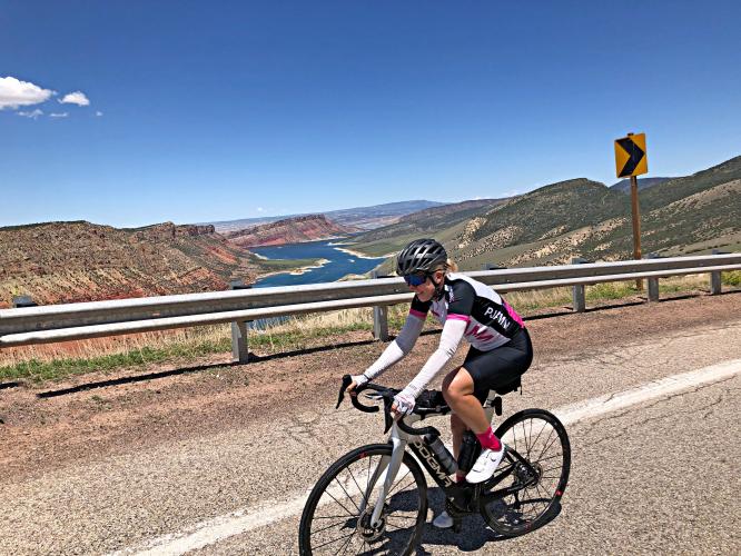
This is the most striking of the three climbs in the area of Vernal and Flaming Gorge. It's also the steepest. The climb begins at the water's edge along Hwy 44 near the Sheep Creek Interpretive Site. To the north the terrain is bare and consists of orange and brown layered rocks and cliffs. To the south it's green with grass fields and trees.

 This is a spectacular climb with views across the river and of mountains throughout. This climb is wide open with fantastic 360 degree scenery. You can see the top of the climb throughout most of the actual climb itself. Much of this ride is at 8% and it can be hot in summertime. The climb is not long but be prepared for heat and take water as there is nothing around for many miles. It's a long way from everything and quite remote but definitely worthwhile if you find yourself in this corner of Utah.

Thank you Bruce and Stacy!!