6
PDI
11.5 mi
DISTANCE
1,598 ft
GAINED
2.5 %
AVG. GRADE
FULL CLIMB STATS
INTRO
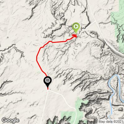
This 11.5 mile bike climb is located in UT, USA. The average gradient is 2.5% and there is a total elevation gain of 1,598 ft, finishing at 6,104 ft.
Use the profile tool, route map, and weather forecast to conquer this cycling climb.
Use the profile tool, route map, and weather forecast to conquer this cycling climb.
PLAN YOUR ROUTE
This climb averages 0%. The steepest quarter mile of this climb is 0%. NaN miles of the climb is at or above 10% grade. The gradient on this climb is broken down as follows:
See more details and tools regarding this climb's grade via our interactive Profile Tool.
See more details and tools regarding this climb's grade via our interactive Profile Tool.
Information Not Available
If you have any information regarding this climb, we'd like to hear from you. Click the CONTRIBUTE button to share your thoughts with us.
Information Not Available
If you have any information regarding this climb, we'd like to hear from you. Click the CONTRIBUTE button to share your thoughts with us.
Before heading out on any cycling adventure check out our Things to Bring on a Cycling Trip and use our interactive check list to ensure you don't forget anything.
Information Not Available
If you have any information regarding this climb, we'd like to hear from you. Click the CONTRIBUTE button to share your thoughts with us.
ROUTE MAP
MEMBER RATING
CURRENT WEATHER
PJAMM TRIPS ADVENTURE STARTER BUNDLES
Check out PJAMM Adventure's prepackaged (self-guided) cycling trips. They will help you plan, document and conquer your next adventure.
NEARBY CLIMBS (0) RADIAL PROXIMITY
FROM No Climbs Found
MEMBER REVIEWS & COMMENTS
Let us know what you thought of this climb. Signup for our FREE membership to write a review or post a comment.
Already have an account?
LOG IN HERE
PerryB
I have ridden this climb about ten times, starting at the Lion's Park bike path trail head at the intersection of Highways 191 and 128 just north of downtown Moab. The path climbs up for about 8 miles before joining Highway 313. From this intersection the highway gradually climbs up, peaking at the turn off for Dead Horse Point State Park. The bike path parallels Highway 191. Both the path and Highway 313 have excellent pavement. The traffic on Highway 313 is a steady stream of tourists in RVs and SUVs, but the shoulder is very wide, the road has good lines of sight, and the cars are well behaved.