Canyonlands National Park, Island in the Sky District
36 mile ride through a national treasure.
![]()
One of five national parks in Utah, Canyonlands National Park (official website) is the United States’ 30th national park, established in 1964, consisting of 337,598 acres. This climb and gorgeous national park are located near Moab National Park and Arches National Park, which are other extraordinary cycling venues. This particular cycling jewel is relatively little-known and not as popular or crowded as some of the other national parks with “just” 739,449 visitors in 2018.

Canyonlands, one of five Utah National Parks.
Canyonlands National Park is made up of four Districts:
- Island in the Sky

View from Green River Overlook
Photo: Neal Herbert, nps.gov
“The Island in the Sky mesa rests on sheer sandstone cliffs over 1,000 feet (304 m) above the surrounding terrain. Every overlook offers a different perspective on Canyonlands' spectacular landscape. Island in the Sky is the easiest area of Canyonlands to visit in a short period of time, offering many pullouts with spectacular views along the paved scenic drive. Hiking trails or four-wheel-drive roads can take you into the backcountry for a few hours or many days” (nps.gov)
- Needles District:

Elephant Canyon, Needles District
Photo: Neal Herbert, nps.gov
“The Needles forms the southeast corner of Canyonlands and was named for the colorful spires of Cedar Mesa Sandstone that dominate the area. Hiking trails offer many opportunities for long day hikes and overnight trips. Foot trails and four-wheel-drive roads lead to such features as Tower Ruin, Confluence Overlook, Elephant Hill, the Joint Trail, and Chesler Park” (nps.gov).
- Maze District:

Chocolate Drops, Maze District
Photo: Mike Hill; nps.gov
“The Maze is the least accessible district of Canyonlands. Due to the district's remoteness and the difficulty of roads and trails, travel to the Maze requires more time. Visitors must be prepared for self-sufficiency and the proper equipment or gear for self-rescue. Rarely do visitors spend less than three days in the Maze, and the area can easily absorb a week-long trip.
The Orange Cliffs Unit of Glen Canyon National Recreation Area shares Canyonlands' western boundary and is administered under the same backcountry management plan and permit/reservation system. While some regulations differ, the information here should assist Orange Cliffs visitors in planning trips” (nps.gov).
- Rivers District:

Big Drops in Cataract Canyon
Photo: Neal Herbert; nps.gov
“The Colorado and Green rivers wind through the heart of Canyonlands, cutting through layered sandstone to form two deep canyons. In stark contrast to the hot, sunny desert above, the river corridors are remarkably green, shady, and full of life.
Both rivers are calm upstream of the confluence, ideal for canoes, kayaks and other shallow water craft. Below the Confluence, the combined flow of both rivers spills down Cataract Canyon with remarkable speed and power, creating a world-class stretch of white water” (nps.gov).
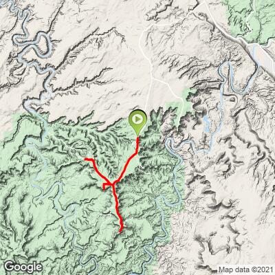
ISLAND IN THE SKY RIDE
We stayed in Moab and this was the closest District to that town, so this is the one we did in our four days of Moab (two days in Arches and one in day Castle Valley).

Begin climb at the Island in the Sky Visitor Center.
THE NECK

The Neck Viewpoint
One-half mile after the Visitor Center
SHAFER VIEWPOINT

Mile 1.

Cycling Shafer Trail -- one of the most epic bike rides in the US
Ride 5.3 miles gaining 1,436’ to 5,823’ at 5.1% average grade.
First half of the climb is at 9%.

The finish of this climb is about one mile before the visitor center.
Ride down 5.3 miles to the start, turn around and ride back up.

I did this trail on my Roubaix with 28mm road tires without any difficulty . . .
That is, other than the 9% first 2.5 miles in 100+ degrees.

One of the most epic and unique bike climbs in the US.
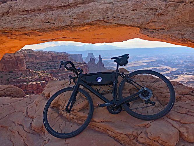
MESA ARCH

Mile 6.

0.7 mile round trip hike.
AllTrails writes of this hike “Mesa Arch Trail is a 0.7 mile heavily trafficked loop trail located near Moab, Utah that features beautiful wild flowers and is good for all skill levels. The trail is primarily used for hiking, walking, and nature trips and is accessible year-round” (AllTrails)
UPHEAVAL DOME

Halfway down the descent of Upheaval Dome Road.
Descend 4.9 miles and then climb back to the junction at 1.6% gaining 490’ to 6,117’.

Mile 22.5 of our route.
GREEN VALLEY OVERLOOK

Mile 29 of our route.
Descend 1.4 miles and then climb back to the junction at 1.5%.
![]()
Weather data from US Climate Data’s website.
Average high temperatures exceed 90° degrees during the summer months. There is little rainfall in this area and the temperatures in May and late September into October are ideal.
How to get around in Canyonlands National Park: Unlike the larger and more popular national parks, there is no public transportation in Canyonlands. So -- you’ve got to use your own vehicle or your bicycle to get from point to point in this canyon wonderland.