Cycling Whiteface Mountain, New York.
Near Lake Placid, this is the top New York bike climb.

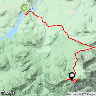
The route to Whiteface Mountain summit from Franklin Falls is less difficult than from the Wilmington side. From Wilmington, the climb to the junction of Route 431 and Veteran’s Memorial Highway is three miles at 8.2%; from Franklin Falls it is 6.4 miles at 2.4% (with 0.6 miles at 10% beginning at mile 4.6).
Before heading out to cycle Whiteface Mountain, be sure to rely on our list of Things to Bring on a Cycling Trip, and use our interactive checklist to ensure you don't forget anything.

Toll Booth is at mile six if you begin the climb from the town of Franklin Falls.
Toll Road: As of June 2020 the toll for cyclists was $15.00. The toll road is open to cyclists during nearly the same hours as automobiles (8:30 a.m. to 5:30 p.m. for autos, 8:30 a.m. to 5:00 p.m. for cyclists). There is dated internet information that reports cyclists are permitted on the Toll Road only after 5 p.m. – this was previously the case, but is no longer.
I began my June 2020 climb at 5:30 a.m. from Wilmington and went around the gate without paying toll. My riding partner rolled up to the gate around 8 a.m., before gates open, but was charged $15.00 by the attendant who spotted him. The attendant advised that my partner wouldn’t have had to pay if he went through without being seen. According to the cycle-based hotel we stayed at in Wilmington (Don at Cadence Lodge, a half block from climb start), it is customary and acceptable for cyclists to ride around the gate before the toll booth opens.
![]()
Whiteface Mountain is the fifth highest peak in the state of New York (after Mount Marcy [5,344’], Algonquin Peak [5,114’], Mount Haystack [4,960’] and Mount Skylight [4,926’]). Most of the climb is on Whiteface Veterans Memorial Highway[1] which is 7.96 miles of the most pristine roadway we have ever cycled on. The roadway was constructed and paid for by New York State. Construction began in 1931 and was completed in 1935.
Note: This section of the climb summary duplicates our Whiteface Mountain from Wilmington climb report, because the climb to the top after turning onto Whiteface Mountain Highway from Route 431 is the same for both climbs -- 5.2 miles gaining 2,310’ at 8.5% average grade and ZERO descent.
Whiteface Mountain bicycle climb, what a ride! So many positives to this climb, which include:
- It is a legitimate Top 50 U.S. climb (#43). It has a consistent moderately steep grade throughout – no flat spots or descents between start and finish.

- There are exceptional views through breaks in the forest that surround us as we climb, including Taylor and Franklin Falls Ponds to the north after you pass the Toll Booth up to the switchback at mile 6.6 where we see Lake Placid for the first time.

- The surroundings are lush and green during the spring and summer.


Well, not all springtimes are created equal . . .
. . . thanks Bo Jensen, Syracuse, NY.

August, 2020
Bo Jensen sporting PJAMM Cycling’s Top 100 US Climbs jersey.
- And, of course, there are the gorgeous fall colors during autumn.

- The top is Spanish Pyrenees-like: a castle! (see last part of Climb Video).

Summit Castle
(Photo from GAD).

Summit Tunnel
(Photo from Green Racing Project).
![]()

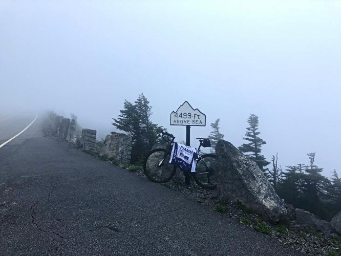
Elevation signs begin at Santa’s Workshop (mile 1.6) and end at the summit.

Finish for the bike.
Walk up the steps for epic views of Lake Placid.

- The descent is amazing (note the 25 mph speed limit).
- Did we mention the 25 mph speed limit? That counts for cars on the ascent, too – so, it’s a safe and comfortable climb.

- Traffic flow is mild (at least on weekdays).
- This is a bike-friendly route with many “Share the Road” signs.

- A fun trivia fact is that six events in the Winter Olympics were held here over eight days in 1980.
- Upstate New York is beautiful.
- The road and its surface is exceptional. We have never encountered a better roadway surface. There were no blemishes anywhere – up or down.

“Whiteface opened in 1958 and has earned its place in the annals of big-mountain skiing. It has the greatest vertical drop in the east, which means if pointing the boards downhill is your thing, you'll have plenty of opportunities” (Whiteface Mountain). If there is an incredible drop for skiers, then there is the equivalent opposite for us climbing the monster!

Slopes of Whiteface Mountain Ski Resort.
Weather for the Whiteface Mountain Bicycle Climb: This can change in an instant on the mountain. We went up in fairly good weather and while taking photos at the top had rain come in surprisingly fast -- check the weather and bring extra gear as warranted.

Ten minutes earlier that view was perfectly clear.
Whiteface is spectacular during the fall:
![]()
![]()
![]()
Final note: If you have the opportunity to climb this mountain, DO IT!
Whiteface Mountain Cycle Climb summary courtesy of then Strava KOM Michael Le Rossignolhe:
"The climb is beautiful and twisty in the last few miles which I love. There is only one small ramp where the gradient goes up and it's in the final 800m which really bites! It was also a lot colder at the top (i made the rookie mistake of not packing any warm clothes since it was in June! The view was spectacular, you can see Montreal (where I'm from) on a clear day. The race was pretty uneventful, there was a small group selected after only 1 mile of around 8 or 10 guys and it slowly became 6 by the 3/4k to go mark and I attacked and stayed away by a minute or so. It was a great event and well organized!"
The Whiteface Mountain bike climb is truly a bucket list cycling climb.
[1]Thanks much and again to our Northeast Cleats on the Ground collaborator extraordinaire Matthew Staller for his invaluable input and assistance on this page.