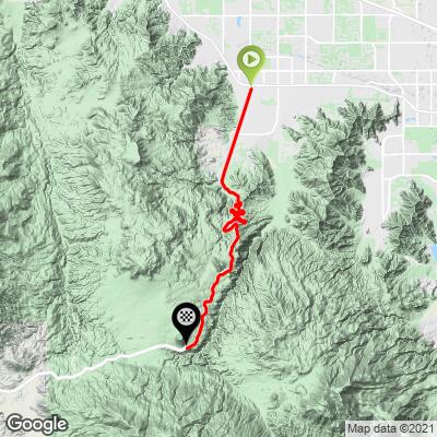
18.4
PDI
13.9 mi
DISTANCE
3,677 ft
GAINED
5 %
AVG. GRADE
FULL CLIMB STATS
Page Contributor(s): Bruce Hamilton, La Quinta, CA, USA
INTRO
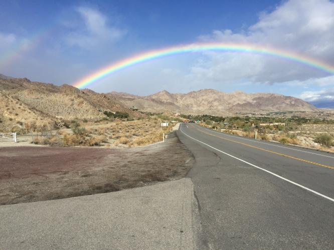
Beginning in Palm Desert, this bike climb takes us into the Santa Rosa Mountains of the Pacific Coast Range.
This is the most significant road bike climb out of the Palm Springs area. While much of the climb is mundane high desert landscape, there are parts of this climb that make it remarkable. Most notably are the dramatic switchbacks encountered from miles 4.5 to 8 and can be viewed from above at Vista Point, mile 8.4. The view of these switchbacks is exceptional, rivaling those in the French Pyrenees and Alps.
PLAN YOUR ROUTE
Average grade is 5.1%. 53% of the climb is at 0-5% and 42% is at 5-10%. The steepest quarter-mile is 8.3%.
See more details and tools regarding this climb's grade via the “Profile Tool” button.
Roadway; Two lane highway in excellent condition but with no to minimal shoulder.
Traffic: Mild to moderate with traffic traveling at highway speeds - this is not a ride for the traffic averse cyclist.
Parking: At the mall to the left adjacent to the start of the climb (Map; Street View).
Weather: It gets hot out here so be sure to consult the PJAMM "Full Forecast" feature to assess what clothing and provisions to bring for the climb. The average high between June and September is 102-108 (U.S. Climate Data).
Before heading out on any cycling adventure check out our Things to Bring on a Cycling Trip and use our interactive check list to ensure you don't forget anything.
Also consider the Tramway Road climb which is a 18 miles away in Palm Springs (Map) the start of which is at the Palm Springs Visitors Center (Google Map + Reviews).
ROUTE MAP
MEMBER RATING
CURRENT WEATHER
PJAMM TRIPS ADVENTURE STARTER BUNDLES
Check out PJAMM Adventure's prepackaged (self-guided) cycling trips. They will help you plan, document and conquer your next adventure.
NEARBY CLIMBS (0) RADIAL PROXIMITY
FROM No Climbs Found
MEMBER REVIEWS & COMMENTS
Let us know what you thought of this climb. Signup for our FREE membership to write a review or post a comment.
Already have an account?
LOG IN HERE
P19342DMJ
This climb is extremely dangerous due to high speed uphill and downhill traffic. It is not recommended at any time or any day. Going uphill there is rarely a shoulder and of course no bike lane. For some reason vehicle traffic feels compelled to drive at the highest rate of speed and cyclists are simply in their way. I found absolutely no respect for my uphill travels. I abandoned with about 1000 feet to go due to the extremely unsafe conditions caused by callous, unsafe, heavy and high speed traffic. I will not ride HWY74 every again
MootsMan
Sooooo. Did this ride on 1/19/23 and today, 1/22/23, the climb is as described. Really cool, but for the fact it's as busy as the 10 during rush hour. I'm no shrinking violet when it comes to traffic, but mid-day during the week and mid-day on Sunday and traffic was whacky both ways. It's not horrible going up, but when you are ripping going down, the turns are not tight enough to put the traffic in your rear-view. Be prepared to be passed while you are doing 35-40mph, and yahoos in F-150s are doing 65, or even better, retirees are doing 2 mph faster than you in their Lexus.
josephbcoolman
I did this ride years ago, back in my racing days. It's long and beautiful. I rode all the way to Mountain Center , Gateway to Idyllwild. It's a good road and when I did it low-ish traffic. It's spectacular to climb out of a desert setting. If you find yourself in Palm Springs, it's a must do….