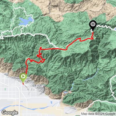
Hwy 330 Bike Climb - PJAMM Cycling

9.7
FIETS
21.6 mi
DISTANCE
5,922 ft
GAINED
5 %
AVG. GRADE

FULL CLIMB STATS

INTRO

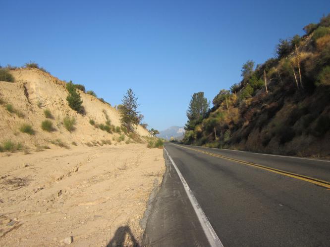
Highway 330 is US #42 Top Bike Climb.  This long ascent is on a fairly gradual gradient much of the way, but along a very, very busy highway with minimal shoulder.  This is a major access road to Big Bear Resort area.  Because of the significant traffic moving at high speed with minimal shoulder in many locations we do not recommend the climb to anyone even slightly traffic averse - if you decide to do the climb, leave at sunrise on a late spring or summer weekend. 
The average grade for this one is 4.9%, (5.7% with descent eliminated).  39% (8.3 miles) is at 0-5% grade, 46% (9.9 miles) is at 5-10%, and 6% (1.4 miles) is at 10-15%.  The steepest quarter-mile is 9.9% and steepest mile 7.7%.

See more details and tools regarding this climb's grade via the “Profile Tool” button.
Roadway:  Excellent condition with a shoulder to ride in much of, but not all of, the route. 

Traffic:  That's the problem with this climb - heavy and fast moving traffic. 

Parking:  At either of the malls just to the west of the start of the climb - MapStreet View
Provisions:  In Running Springs at mile 14.5 and ArrowBear Lake at mile 16.
Before heading out on any cycling adventure check out our Things to Bring on a Cycling Trip and use our interactive check list to ensure you don't forget anything.
Leave at sunrise during the summer (not ski season) to avoid as much traffic as possible. 

ROUTE MAP

MEMBER RATING

Not Yet Rated
-
Road
-
Traffic
-
Scenery

CURRENT WEATHER

PJAMM TRIPS ADVENTURE STARTER BUNDLES

Check out PJAMM Adventure's prepackaged (self-guided) cycling trips. They will help you plan, document and conquer your next adventure.
ALL TRIPS
Browse all of our prepackaged trips and find your next adventure!
San Gabriel Mountains
United States (CA)
38 ROUTES
43 POIs
ROUTE STATS (TOTAL)
677.5
mi
DISTANCE
80,483
ft
ELEV. GAIN

NEARBY CLIMBS (0) RADIAL PROXIMITY

FROM
No Climbs Found

MEMBER REVIEWS & COMMENTS

Let us know what you thought of this climb. Signup for our FREE membership to write a review or post a comment.
Already have an account?
ROUTE MAP
PROFILE TOOL
Route Data
S.G. (%)
hide
Segment Data
hide

Climb Profile Not Found
CLIMB SUMMARY

IMG_1635.JPG

Cycling Hwy 330 - this is one of the more dangerous Top 100 US Bike Climbs

Ride 21.7  miles gaining 6,657’ to elevation 7,111 at 5% average grade.

Hwy 330 is a fairly gradual climb along a very, very busy highway with minimal shoulder.  

At mile 14,  we enter the quiet town of Running Springs where provisions can be acquired.  

IMG_1642.JPG

Running Springs (pop. 4,862; 2010)


I do not recommend this ride because of the narrow shoulder and fast moving highway traffic.    One caveat to this warning is that this was one of the first climbs I documented in 2014 when I started this website and at that time I was more sensitive to highway traffic - I am now almost fully desensitized to highway traffic so I may not feel as strongly about the hazard level of the roadway now as then.

Strava member Steve Mooney - Jenson, USA writes in response to my inquiry about why he referred to Hwy 330 as “treacherous” in a Strava post:


John, I’ve lived here since 1970. Hwy 330 is two lanes at 6% grade for 10+ miles. There is not much shoulder and cars are traveling fast to get up the hill. One should ride it at off-peak hours. The descent on a Sunday morning is a blast! Perhaps treacherous was a bit of hyperbole for a seasoned rider—perhaps it was the endorphins stimulated by the mere mention of it😀. If I’m heading up the hill, I prefer the 138. Again, off-peak hours are the smarter choice.


Strava member Evan Turner writes:

Very little space for a cyclist! Cars are extremely respectful though. Traffic was light on this sat afternoon. All around safety rating of 5/10.

Strava member John Franklin writes:


Traffic was busy in places, especially for early in a Sunday. Narrow in places and generally cars waited but I also had the only experience of someone slowing down to shout at me even though I was about 1ft from the ditch. Feltike there were less passing places than other climbs but they could have been my imagination as there was just more traffic. I'd do it again though!

Top 100 rides in 50 mile radius are #47 Hwy 18,  6.4 miles northeast,  #85 Hwy 38/Valley of the Falls 8.9 miles southeast,  #19 Mt. Baldy 31 miles west.

Steepest ¼ and mile are at the very beginning of the climb (9.7% and 7.6% respectively)

Access to full Climb Summary requires a PJAMM Cycling PRO Membership!

It takes less than a minute to sign up & with your PRO membership you can:
  • Rate climbs, post comments and share your experiences on any of our climb pages
  • Create bucket lists of climbs & mark the dates you complete them
  • Weather data for all climbs - Start & Finish
  • Upload photos to your member page to customize your PJAMM Cycling experience
  • Utilize all of our interactive tools - Profile & Routes in Area
  • Download climb route .gpx files
LEARN MORE
SIGN UP

Already have an account? LOG IN HERE