![]()
Cycling Parpaillon Tunnel from the north (partly gravel for the last 10 km)
Ride 25 kilometers gaining 1,720 meters at 6.7%.
![]()
Cycling Papaillon Tunnel from the south (partly gravel for the last 10 km)
Ride 17 kilometers gaining 1,280 meters at 7.4% .
Ride summary from Erwan Treguier, Brittany, France.
Note: the last 10 km -more or less- on each side are unpaved, cf. doted lines on the attached map.
![]()
The broken lines leading to Parpaillon tunnel are the gravel portion of the approaches.
This is one of the great gravel cycling climbs in France. Formerly the highest road in France,
![]()
Mountain bike recommended.
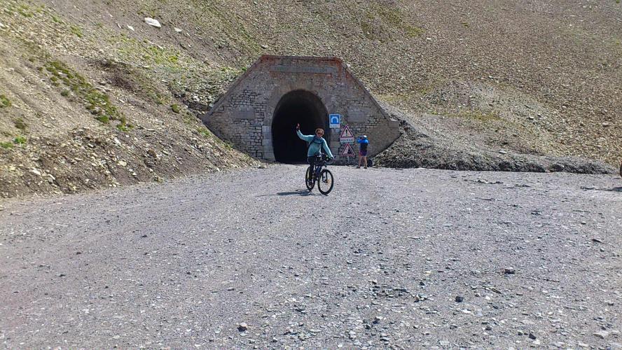
Both sides of the mythical Parpaillon tunnel (~2640m)
Its construction by the French army began in 1891. The tunnel was completed in 1901, but the work on the road lasted until 1911. When most of the roads of the great Alpine passes were refurbished and paved (after WW II), the Col de Vars (500m lower, which also links the valleys of the Durance and Ubaye) became the favoured itinerary. As a result, this ‘fossil’ road probably gives us a good idea of what the climbs of the first Tours de France looked/felt like . . .
![]()
Have to start early to get in both sides.
I started from the church of Saint-André d'Embrun, in the Durance valley, heading towards Crévoux. Before arriving at the village of Crévoux, I turned left towards la Chalp (the direction of the Parpaillon is indicated). The ‘montée du Parpaillon’ signs indicate the distance until the end of the asphalt road (at the pont du Réal)... but it is precisely there that things start to get tough!
![]()
There are still about ten km of track to reach the tunnel and enjoy its 500m of fresh darkness! Lights are recommended to ride through it... and beware of vehicles (it's not very wide!) as well as mud and icy water puddles. For claustrophobic people, no need to panic: signs indicate the distance until each end of the tunnel... to know in which direction to run! :)
![]()
![]()
![]()
![]()
![]()
![]()
![]()
![]()
![]()
![]()
![]()
![]()
![]()
Bring lights.
![]()
We change department mid-way in the tunnel (from the Hautes-Alpes to the Alpes-de-Haute-Provence). On the Ubaye side the track is not getting any better: I rode down until the Pont du Bérard, where a pretty old-fashioned stone marker indicates the distances (with an unbelievable millimetric precision!) for several destinations, before climbing back to the tunnel. On the way back, I was really happy to be back on the asphalt for the last (pleasant) part of the descent... so smooth compared to the (long) downhill trail section, a bit rough, even with my full suspension mountain bike!
![]()
The Pont du Bérard vintage kilometric stone on the South side, where Erwan turned back towards the tunnel
Nb: Make sure the tunnel is open before trying! At the beginning of summer, the heavy metal doors of the tunnel are still closed due to snow/ice. There is still the Col du Parpaillon, above (2783m), which can be crossed by foot... but it would be a shame to miss the tunnel!
http://www.inforoute05.fr/www/index.html

 We've partnered with Sherpa-Map.com to bring you the best route planning tool. With a PRO Membership you can use this climb as a reference when creating your route.

