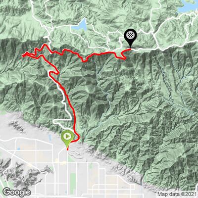
26.4
PDI
12.7 mi
DISTANCE
4,364 ft
GAINED
6.4 %
AVG. GRADE
FULL CLIMB STATS
INTRO
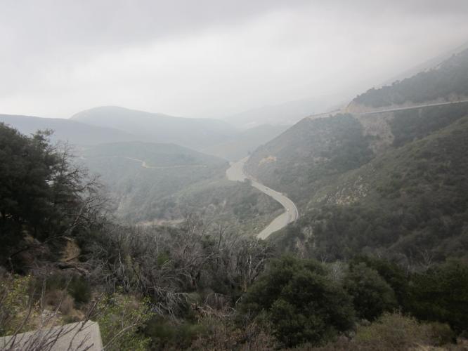
Highway 18-Old Waterman Canyon is a fairly gradual climb, but for the 2.9 miles at 8.8% along Old Waterman Canyon Road. Other than the by-pass off of Highway 18 for the 2.9 miles of Old Waterman Canyon, this is a seemingly treacherous ride.
"This route includes single lane on steep Old Waterman Canyon Road. After 1.1 miles on four lane Route 18 turn right onto Old Waterman Canyon Road. Soon you descend a short distance but then the grade steepens as you climb a narrow and twisty road. After 3.2 miles get back on Route 18 to continue. This final section is over moderate grade and again four lanes and traffic most days. Toward the top the grade eases and the listed climb ends in the small community of Crest Forest." (This quote presented with the approval of John Summerson from The Complete Guide to Climbing (by Bike) in California, p 204)
PLAN YOUR ROUTE
Average grade 6.4%. 57% of the climb is at grades 5-10%. The steepest quarter mile is 11.5% and mile 9.5%.
See more details and tools regarding this climb's grade via the “Profile Tool” button above.
Roadway: On busy highway 18 for all but 3 miles. The road is i good condition but is a 4 lane highway until mile 8.2 and thereafter still a busy 2 lane highway with not much shoulder to speak of.
Traffic: Heavy - this climb is not recommended.
Parking: On the street on E 48th Street at climb start - Map; Street View.
Information Not Available
If you have any information regarding this climb, we'd like to hear from you. Click the CONTRIBUTE button to share your thoughts with us.
Before heading out on any cycling adventure check out our Things to Bring on a Cycling Trip and use our interactive check list to ensure you don't forget anything.
Hwy 18-Old Waterman Canyon is a fairly gradual climb, but for the 2.9 miles at 8.8% along Old Waterman Canyon Rd. Other than the by-pass off of Hwy 18 for the 2.9 miles of Old Waterman Canyon, this is a seemingly treacherous ride. The road, for the first mile before the Old Waterman cut-off and for the remaining 9 miles after merging back onto the Highway (more like freeway) at the top of Old Waterman, is busy with very fast moving traffic and a narrow shoulder for most of the climb. We do not recommend this ride because of the narrow shoulder and fast traffic.
ROUTE MAP
MEMBER RATING
CURRENT WEATHER
PJAMM TRIPS ADVENTURE STARTER BUNDLES
Check out PJAMM Adventure's prepackaged (self-guided) cycling trips. They will help you plan, document and conquer your next adventure.
NEARBY CLIMBS (0) RADIAL PROXIMITY
FROM No Climbs Found
MEMBER REVIEWS & COMMENTS
Let us know what you thought of this climb. Signup for our FREE membership to write a review or post a comment.
Already have an account?
LOG IN HERE
JonLested
The lowest slopes before getting on Hwy 18 are TOUGH, hitting stretches of 13%. Once on Hwy 18 the gradient lessens and is more consistent. The views are amazing; however, keep your head on a swivel due to the heavy traffic on the twisty roadway. It is NOT for the traffic-averse rider. There are a number of pullouts/scenic viewpoints to take the scenery or just take a break from dealing with the traffic. If you want a two-fold challenge (climb and traffic), Hwy 18/Old Waterman Canyon is your ticket.