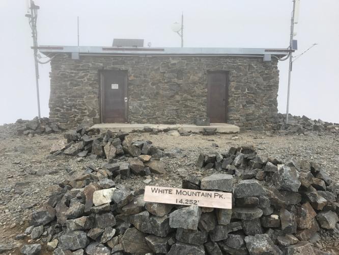
White Mountain Peak (Bishop) Bike Climb - PJAMM Cycling

97.6
PDI
31.9 mi
DISTANCE
11,963 ft
GAINED
6 %
AVG. GRADE

FULL CLIMB STATS

Page Contributor(s): Dan Magaw, Auburn, CA, USA; Greg Mahterly, Encinitas, CA, USA.

INTRO

This is a VERY CHALLENGING mountain bike climb to the highest road (not paved) in California.

See more details and tools regarding this climb's grade via our interactive Profile Tool.
We have heard that the first 11 miles are barely mountain bike territory. If you have any insight, please comment below!
Information Not Available

If you have any information regarding this climb, we'd like to hear from you. Click the CONTRIBUTE button to share your thoughts with us.

Before heading out on any cycling adventure check out our Things to Bring on a Cycling Trip and use our interactive check list to ensure you don't forget anything.
We would suggest staying in Bishop at the Creekside Inn. Don't miss out on pastries at Schat's next to the Creekside Inn. 

ROUTE MAP

MEMBER RATING

Difficulty: Extreme
2
Road
5
Traffic
5
Scenery

CURRENT WEATHER

PJAMM TRIPS ADVENTURE STARTER BUNDLES

Check out PJAMM Adventure's prepackaged (self-guided) cycling trips. They will help you plan, document and conquer your next adventure.
ALL TRIPS
Browse all of our prepackaged trips and find your next adventure!
Death Valley
United States (CA)
21 ROUTES
34 POIs
ROUTE STATS (TOTAL)
553.3
mi
DISTANCE
55,125
ft
ELEV. GAIN
Owens Valley: Bishop
United States (CA)
19 ROUTES
26 POIs
ROUTE STATS (TOTAL)
268.3
mi
DISTANCE
55,531
ft
ELEV. GAIN
Owens Valley: Lone Pine
United States (CA)
15 ROUTES
31 POIs
ROUTE STATS (TOTAL)
157.7
mi
DISTANCE
51,016
ft
ELEV. GAIN

NEARBY CLIMBS (0) RADIAL PROXIMITY

FROM
No Climbs Found

MEMBER REVIEWS & COMMENTS

Let us know what you thought of this climb. Signup for our FREE membership to write a review or post a comment.
Already have an account?

Apr 10, 2024
difficulty: Extreme
scenery: 5
traffic: 5
road: 2
Apr 10, 2024
scenery: 5
traffic: 5
road: 2
This is an amazing climb on a Full suspension MTB. on Silver Canyon there were 10 stream crossings in the first 5 miles. Sometimes over a foot deep in places. So plan on getting your feet wet. The grade keeps increasing as you approach the first switchback. Then it's game on as you climb 3,600 feet in just 4 miles at average 16.7% grade and ramps to 28%. At 10,480 feet you reach White Mountain Road with stunning views in all directions. The descent is my all time favorite on a MTB. Long steep very fast and challenging with breaktaking views all the way down.
Oct 13, 2022
Rode this on October 11, 2022 from start to the ridgeline on a Salsa Cutthroat with a 46T gear. It was not enough. This is NOT a gravel ride. This is an MTB ride with stream crossings, pyramidal shale rock that will slice your tires, etc. etc. If you carry water filtration/tablet/UV purifier you can carry 1 bottle then load up where the road departs from the stream, about a mile after the "DIFFICULT" 4x4 warning sign. That is also where this climb goes into hyper-steep, >15% IMHO.
ROUTE MAP
PROFILE TOOL
Route Data
S.G. (%)
hide
Segment Data
hide
CLIMB SUMMARY

Cycling White Mountain to its peak from Bishop

Ride 32 miles gaining 12,025’ to 14,252’ at 6.1%.

This is a MONSTER bike climb - it would be #2 US/#7 World if ranked  

Greg Matherly writes:  It’s funny, I can’t really explain why Silver Canyon is so hard. I’ve done it 4 times. The numbers aren’t that crazy, but the combination of pitch, altitude, exposure, struggle for traction, the need to “power” over rocks/ruts...and maybe just the reality of knowing how much further you have to go? It punches you in the mouth!

Locked gate ~7 miles from the peak.

Photo and ride article:  TheRadavist.com

This is a fully unsupported climb over very difficult challenging terrain that becomes nearly impossible to ride over the last mile or so.

Some sections are tough even on a mountain bike.

It’s worth it!!!

Ancient Bristlecone tree (oldest

Photo and ride article:  Windinmyface.com