
22.5
PDI
10.8 mi
DISTANCE
3,662 ft
GAINED
6.4 %
AVG. GRADE
FULL CLIMB STATS
Page Contributor(s): Ard Oostra, Switzerland
INTRO
Collado de Sahún is a mountain pass in the Spanish Pyrenees that links Huesca province's Ribagorza and Sobrarbe districts, climbing 17.3 km (10.8 mi) from the village of Chía and gaining 1,116 m (3,662 ft) at a 6.4% average grade to the 2,010 m (6,593 ft) summit.
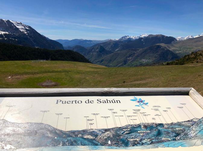
The defining feature of this climb is its surface: roughly the first 5 km out of Chía are paved, then the road becomes an unpaved forest track - a mix of hardpack and looser gravel - through around ten hairpins to the pass. The upper slopes open onto bare alpine grass and rock, with the Ibón de Barbarisa waterfall and, on a clear day, distant views of the Aneto and Maladetas massifs, the highest peaks in the Pyrenees.
This is also a climb in the middle of changing. Valley residents on both sides have wanted a paved, winter-usable link between Chía and the Sobrarbe village of Plan for decades, and in 2026 the Aragón government began a €7.5 million project to pave and widen the full 25 km Plan-Chía track, with work expected to continue into 2027-2028. Until then, expect a patchwork of newly finished pavement alongside active construction and still-rough gravel.
PLAN YOUR ROUTE
 We've partnered with Sherpa-Map.com to bring you the best route planning tool. With a PRO Membership you can use this climb as a reference when creating your route.
 Collado de Sahún averages 6.4% over its full 17.3 km (10.8 mi), but that number smooths over a lot of variation between the paved lower section and the unpaved upper track.
The steepest kilometer comes early and averages 9.8%, with the opening 2 km sitting at 9.2% before the grade eases through a rolling mid-section. By the 10 km mark the running average has settled to 7.0%, and the final kilometers to the 2,010 m (6,593 ft) summit are noticeably gentler than the lower slopes. Most of the real work on this climb happens in its first third, on the switchbacks above Chía.
Roadway: The first roughly 5 km out of Chía are paved (concrete near the village, then asphalt); beyond that the route is an unpaved forest track - hardpack with looser gravel and some runoff rutting - the rest of the way to the pass. That's changing: the Aragón government began a multi-year project in 2026 to pave and widen the full 25 km Plan-Chía track, so expect a mix of freshly paved stretches, active construction, and still-rough gravel through at least 2027-2028. A gravel or cyclocross bike is the safer call until the work is finished.
Traffic: Very light. This is a quiet mountain track between two small Pyrenean valleys rather than a through route, though construction vehicles and equipment are a regular presence during the project's active work windows, roughly August through December each year.
Parking: Chía is a small village with easy but informal roadside parking near where the climb begins. There's no dedicated trailhead lot - park considerately on the village's edge and leave room for local residents and construction traffic.
A gravel or cyclocross bike, or a road bike fitted with wider tires (28mm or more), is the right tool here given the unpaved upper two-thirds of the route - a standard narrow-tired road bike will struggle on the looser gravel sections.
Chía itself has no bike shop or bar. The nearest services are in Castejón de Sos, about ten minutes down the valley, which has a supermarket and several restaurants. Carry all the water and food you'll need for the climb - there's nothing along the route until the pass itself.
Before heading out on any cycling adventure check out our Things to Bring on a Cycling Trip and use our interactive check list to ensure you don't forget anything.
Castejón de Sos, just down the Ésera valley from Chía, is the natural base for this climb - known across Spain as the country's paragliding capital, with a cluster of flight schools and the area's best selection of hotels and casas rurales. The Benasque valley above it is one of the best-known hiking and climbing bases in the Spanish Pyrenees, centered on the Aneto and Maladetas massifs that are visible in the distance from Collado de Sahún's upper switchbacks.
Because the pass sits above 2,000 m and its surface is actively being reworked, conditions can change quickly with the weather - our Weather tool is worth a check for current conditions at the summit before committing to the unpaved sections.
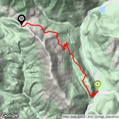
ROUTE MAP
MEMBER RATING
CURRENT WEATHER
PJAMM TRIPS ADVENTURE STARTER BUNDLES
Check out PJAMM Adventure's prepackaged (self-guided) cycling trips. They will help you plan, document and conquer your next adventure.
NEARBY CLIMBS (0) RADIAL PROXIMITY
FROM No Climbs Found
MEMBER REVIEWS & COMMENTS
Let us know what you thought of this climb. Signup for our FREE membership to write a review or post a comment.
Already have an account?
LOG IN HERE
