
18.9
PDI
5 mi
DISTANCE
2,442 ft
GAINED
9.2 %
AVG. GRADE
FULL CLIMB STATS
Page Contributor(s): Ard Oostra, Switzerland
INTRO
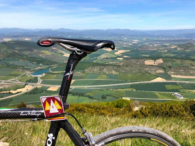
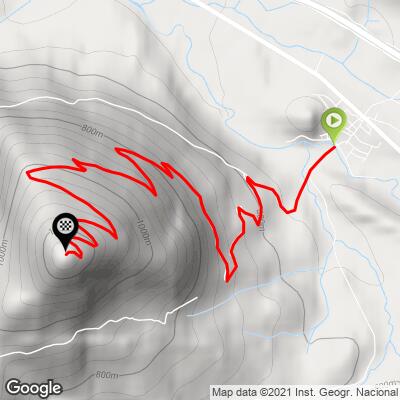
Monreal (NA-2420) climbs La Higa de Monreal, the lone, cone-shaped mountain that rises over the village of Monreal in Navarra's Elorz valley, southeast of Pamplona. Our route covers 8.0 km (5.0 mi) and gains 744 m (2,442 ft) at a 9.2% average grade, finishing at 1,265 m (4,151 ft), just below La Higa's 1,289 m (4,229 ft) summit.
This climb comes in two very different halves. The first 3 km out of Monreal are a gentle warm-up on a narrow farm lane, averaging about 6.5% with wide views back over the wheat fields of the valley. Then the mountain gets serious: the final 5 km average close to 11%, and the road turns into a rough, loose-gravel service track that winds up to the radio and telecom masts on the summit.
At the top, the Ermita de Santa Bárbara - the chapel of Monreal's patron saint, and the only survivor of eight hermitages that once stood around the village - sits on the crest with sweeping views over the patchwork farmland of central Navarra. Every May 1, people from the surrounding villages walk up for a romería (pilgrimage) to the chapel. It's a short climb, but with this much gradient and gravel packed into its upper half, it rides much bigger than its distance.
PLAN YOUR ROUTE
 We've partnered with Sherpa-Map.com to bring you the best route planning tool. With a PRO Membership you can use this climb as a reference when creating your route.
Monreal (NA-2420) is 8.0 km (5.0 mi) long and gains 744 m (2,442 ft) at an average grade of 9.2%, climbing from 531 m (1,742 ft) in Monreal to 1,265 m (4,151 ft) near the summit of La Higa.
That average undersells how back-loaded this climb is. The first 3 km average about 6.5%, with a short, easier stretch between km 2 and km 3. From there the gradient rarely lets up: km 4 averages about 10.2%, km 5 about 12.6%, km 6 about 11.6%, and the last two kilometers stay above 9.5%. The final 5 km average roughly 10.8%.
The steepest 500 m averages 15.3%, the steepest 1 km 12.8%, the steepest 2 km 12.3%, and the steepest 5 km 11.0% - all in the upper half of the climb, where loose gravel makes holding traction on the steepest pitches part of the challenge.
Roadway: The lower part of the climb out of Monreal is paved - a narrow, single-lane farm road with no center line. Higher up, it becomes a rough service track to the summit's radio and telecom masts, with loose gravel and patches of broken old asphalt on the steep upper switchbacks. We rode it on a road bike in 2019, but wider tires (28 mm or more) make the upper section far more manageable, and the descent on loose gravel calls for real caution.
Traffic: Very light. Beyond village traffic in Monreal, expect only the occasional farm vehicle or maintenance truck servicing the masts, plus hikers - La Higa is a popular walk from the village and has hosted a local mountain race, the Xtreme Higa de Monreal. The May 1 romería to the summit chapel brings the biggest crowd of the year.
Parking: Monreal is a small village on the Aragonese branch of the Camino de Santiago, with no dedicated trailhead lot - street parking in the village near the start is the practical option. The village also has a picnic area, a handy spot to kit up before the climb or regroup afterward.
Monreal is the last stop for supplies: the village has bars, a small supermarket, a pharmacy and a public fountain, and there's nothing on the mountain itself, so fill your bottles before you start. With pitches above 15% on loose gravel, low gearing matters more than usual here - a compact crankset with a 32- or 34-tooth large cog is a sensible setup. Run wide, durable tires with enough tread and pressure margin for sharp gravel, and carry a spare tube and a tire boot. The summit is open and exposed to wind, so bring a light jacket for the descent even on a warm day in the valley.
Before heading out on any cycling adventure check out our Things to Bring on a Cycling Trip and use our interactive check list to ensure you don't forget anything.
Monreal has more history than its size suggests. The Kings of Navarre built a castle on the hill here - one of the kingdom's key fortresses, controlling access between the Pamplona basin and the Pyrenean valleys, and a royal residence where the Cortes met - before it was ordered demolished after the Castilian conquest; the base of the keep and a rainwater cistern survive. In the Middle Ages the town received the Fuero de Estella, allowing a weekly market that drew Frankish and Jewish merchants, each settling their own quarter.
Pilgrims on the Camino still cross the river Elorz on Monreal's Gothic bridge, which remains open to foot traffic. If you have time to explore nearby, the medieval bridge at Salinas de Ibargoiti and the Romanesque hermitage of Eunate are both short drives away, and Pamplona is close enough for an easy evening visit. To pair La Higa with other rides in the area, see the nearby climbs on our Routes in the Area tool.
ROUTE MAP
MEMBER RATING
CURRENT WEATHER
PJAMM TRIPS ADVENTURE STARTER BUNDLES
Check out PJAMM Adventure's prepackaged (self-guided) cycling trips. They will help you plan, document and conquer your next adventure.
NEARBY CLIMBS (0) RADIAL PROXIMITY
FROM No Climbs Found
MEMBER REVIEWS & COMMENTS
Let us know what you thought of this climb. Signup for our FREE membership to write a review or post a comment.
Already have an account?
LOG IN HERE
