3.7
PDI
2.8 mi
DISTANCE
759 ft
GAINED
4.8 %
AVG. GRADE
FULL CLIMB STATS
INTRO
This 2.8 mile bike climb is located in VT, USA. The average gradient is 4.8% and there is a total elevation gain of 759 ft, finishing at 1,525 ft.
Use the profile tool, route map, and weather forecast to conquer this cycling climb.
Use the profile tool, route map, and weather forecast to conquer this cycling climb.
PLAN YOUR ROUTE
This climb averages 0%. The steepest quarter mile of this climb is 0%. NaN miles of the climb is at or above 10% grade. The gradient on this climb is broken down as follows:
See more details and tools regarding this climb's grade via our interactive Profile Tool.
See more details and tools regarding this climb's grade via our interactive Profile Tool.
Information Not Available
If you have any information regarding this climb, we'd like to hear from you. Click the CONTRIBUTE button to share your thoughts with us.
Information Not Available
If you have any information regarding this climb, we'd like to hear from you. Click the CONTRIBUTE button to share your thoughts with us.
Before heading out on any cycling adventure check out our Things to Bring on a Cycling Trip and use our interactive check list to ensure you don't forget anything.
Information Not Available
If you have any information regarding this climb, we'd like to hear from you. Click the CONTRIBUTE button to share your thoughts with us.
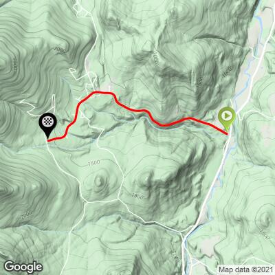
ROUTE MAP
MEMBER RATING
CURRENT WEATHER
PJAMM TRIPS ADVENTURE STARTER BUNDLES
Check out PJAMM Adventure's prepackaged (self-guided) cycling trips. They will help you plan, document and conquer your next adventure.
NEARBY CLIMBS (0) RADIAL PROXIMITY
FROM No Climbs Found
MEMBER REVIEWS & COMMENTS
Let us know what you thought of this climb. Signup for our FREE membership to write a review or post a comment.
Already have an account?
LOG IN HERE
Mikey62481
This starts off with a couple very short steep segments. The crux of this short climb is in in the middle there's a 0.2 segment that's around 11%, but really that's the end of the hard climbing. This section is also before where they were doing road construction. Traffic was really busy on the road when I did it—however the closer you get to Sugar Ski Resort the less traffic it felt like. The road quality was in great shape, so it was a good descent. There was some construction being done on a small section around the midway point but half the road was open to 1 lane for that brief segment. The scenery had some decent views in the Fall and was pleasant at the base of Sugarbush!