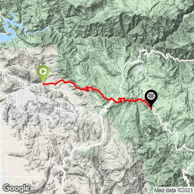
Hwy 180 & 198 Bike Climb - PJAMM Cycling

9.4
FIETS
25.5 mi
DISTANCE
6,248 ft
GAINED
4.5 %
AVG. GRADE

FULL CLIMB STATS

INTRO

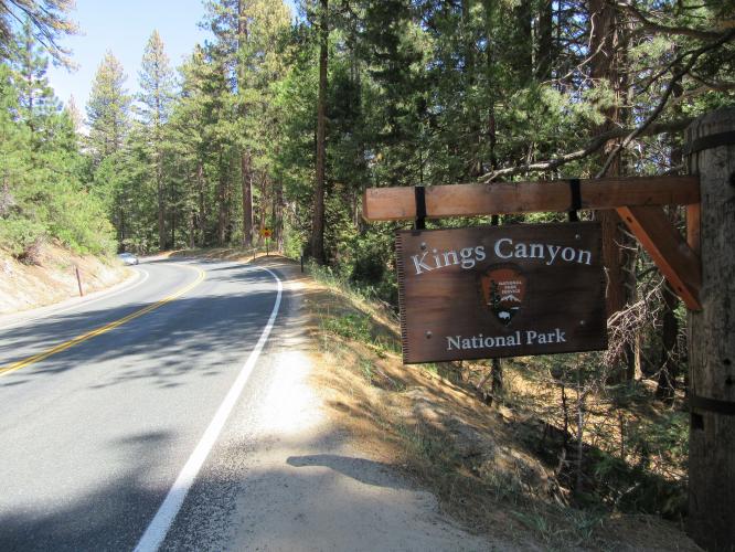
This climb is #53 on the Top 100 U.S. Climb Index and follows Highway 180 east up and through Kings Canyon Road to Generals Highway and the top of the climb where Highway 180 intersects Highway 198. Check out our Sequoia and Kings Canyon National Parks Pages for more information on climbs in the area.
"The west side of Route 180 is a long climb east of Fresno, CA that leads into Kings Canyon National Park. It is along steady grade for the most part and with a few switchbacks in one section. Good views and big trees near the top help ease the pain of a long climb.  After ~ 19 miles you pass through the park entrance gate...and the hill crests soon after at a junction." (This quote is presented with the approval of John Summerson, from his book, The Complete Guide to Climbing (by Bike) in California, pg. 154.)

See more details and tools regarding this climb's grade via our interactive Profile Tool.
Information Not Available

If you have any information regarding this climb, we'd like to hear from you. Click the CONTRIBUTE button to share your thoughts with us.

Information Not Available

If you have any information regarding this climb, we'd like to hear from you. Click the CONTRIBUTE button to share your thoughts with us.

Before heading out on any cycling adventure check out our Things to Bring on a Cycling Trip and use our interactive check list to ensure you don't forget anything.
Information Not Available

If you have any information regarding this climb, we'd like to hear from you. Click the CONTRIBUTE button to share your thoughts with us.

ROUTE MAP

MEMBER RATING

Difficulty: Challenging
5
Road
3
Traffic
3
Scenery

CURRENT WEATHER

PJAMM TRIPS ADVENTURE STARTER BUNDLES

Check out PJAMM Adventure's prepackaged (self-guided) cycling trips. They will help you plan, document and conquer your next adventure.
ALL TRIPS
Browse all of our prepackaged trips and find your next adventure!
Sequoia and Kings Canyon
United States (CA)
15 ROUTES
11 POIs
ROUTE STATS (TOTAL)
281
mi
DISTANCE
77,122
ft
ELEV. GAIN
Yosemite National Park
United States (CA)
29 ROUTES
33 POIs
ROUTE STATS (TOTAL)
376
mi
DISTANCE
42,565
ft
ELEV. GAIN

NEARBY CLIMBS (0) RADIAL PROXIMITY

FROM
No Climbs Found

MEMBER REVIEWS & COMMENTS

Let us know what you thought of this climb. Signup for our FREE membership to write a review or post a comment.
Already have an account?

May 10, 2021
difficulty: Challenging
scenery: 3
traffic: 3
road: 5
May 10, 2021
scenery: 3
traffic: 3
road: 5
This is a long climb on excellent pavement with views of the valley and mountains to keep you entertained as you climb. Once you reach the King's Canyon park entrance you get a view of a few large Redwood trees. 180 is the busiest road in the area with cars passing you relatively frequently, although the traffic does thin out the closer you get to the park. If I were to do it again, I would take Dunlap Road to 245 to 180 to 198 which climbs the same mountain with the same views but you have the road all to yourself. I descended this way and encountered almost no cars. On this alternative route you can see 180 across the valley as you climb.
ROUTE MAP
PROFILE TOOL
Route Data
S.G. (%)
hide
Segment Data
hide

Climb Profile Not Found
CLIMB SUMMARY

Cycling Hwy 180-198 Kings Canyon National Park - a very scenic southwestern Sierras bike climb.

Ride 25.6 miles gaining 6,865’ to 7,585’ elevation at 4.5% average grade.


This climb is #44 on the Top 100 U.S. Bike Climb Index and follows Hwy 180 east (E Kings Canyon Road)  to Hwy 198 (Generals Highway) to Big Baldy Trailhead.  

IMG_1455.JPG

Enter Kings Canyon National Park at mile 17.1

IMG_1455.JPG

2018 entry (up to 7 days) for bicycle was $20.

IMG_1455.JPG

We merge with the Hwy 198 climb at mile 18.8

IMG_1455.JPG

We are also in the Sequoia National Forest for this climb.

However, there are no Giant Sequoia Redwoods along the road.

However . . .

Ride through 2.JPG

Whitaker Forest Ride - turn off is 3.1 miles from our finish (22.4 miles from the start).

Access the ride through tree by turning right at the “Redwood Canyon 2 miles sign”

The ride through tree is 1.2 miles at 7.6% down dirt Forest 14S75 (manageable on road bike).

Turn right onto Whitaker Forest Road at mile 12.5 and ride down about a mile to the "ride through tree" (well, that's what we call it - see slideshow) which is on your right - pretty cool stuff and well worth the ride - go another mile to where the road briefly levels off and you are surrounded by a grove of incredible Sequoia trees.

Nice views along Generals Highway (Hwy 198)

IMG_1472.JPG

IMG_1472.JPG

IMG_1455.JPG

The Hwy 21-245-180-198, Hwy 180 and Whitaker Forest bike climbs end here.

If we continue past the Big Baldy Trailhead (another 20 miles of rollers +1,663’ and =2,409’) we ride to the largest tree by volume in the world (General Sherman Tree).  

    IMG_3209.JPG

IMG_3208.JPG

Steepest ¼ mile begins at mile 4.6 (8.9%); steepest mile begins at mile 2.6 (6.6%)

Access to full Climb Summary requires a PJAMM Cycling PRO Membership!

It takes less than a minute to sign up & with your PRO membership you can:
  • Rate climbs, post comments and share your experiences on any of our climb pages
  • Create bucket lists of climbs & mark the dates you complete them
  • Weather data for all climbs - Start & Finish
  • Upload photos to your member page to customize your PJAMM Cycling experience
  • Utilize all of our interactive tools - Profile & Routes in Area
  • Download climb route .gpx files
LEARN MORE
SIGN UP

Already have an account? LOG IN HERE