6.8
PDI
2.3 mi
DISTANCE
990 ft
GAINED
8 %
AVG. GRADE
FULL CLIMB STATS
INTRO
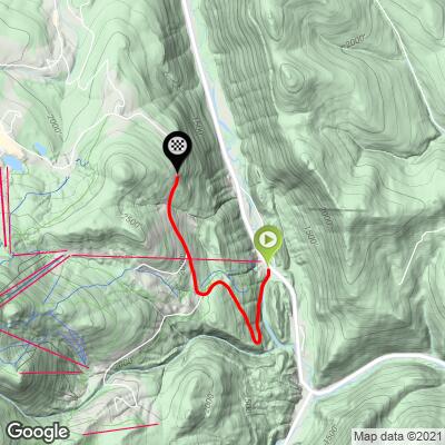
This 2.3 mile bike climb is located in VT, USA. The average gradient is 8% and there is a total elevation gain of 990 ft, finishing at 2,232 ft.
Use the profile tool, route map, and weather forecast to conquer this cycling climb.
Use the profile tool, route map, and weather forecast to conquer this cycling climb.
PLAN YOUR ROUTE
This climb averages 0%. The steepest quarter mile of this climb is 0%. NaN miles of the climb is at or above 10% grade. The gradient on this climb is broken down as follows:
See more details and tools regarding this climb's grade via our interactive Profile Tool.
See more details and tools regarding this climb's grade via our interactive Profile Tool.
Information Not Available
If you have any information regarding this climb, we'd like to hear from you. Click the CONTRIBUTE button to share your thoughts with us.
Information Not Available
If you have any information regarding this climb, we'd like to hear from you. Click the CONTRIBUTE button to share your thoughts with us.
Before heading out on any cycling adventure check out our Things to Bring on a Cycling Trip and use our interactive check list to ensure you don't forget anything.
Information Not Available
If you have any information regarding this climb, we'd like to hear from you. Click the CONTRIBUTE button to share your thoughts with us.
ROUTE MAP
MEMBER RATING
CURRENT WEATHER
PJAMM TRIPS ADVENTURE STARTER BUNDLES
Check out PJAMM Adventure's prepackaged (self-guided) cycling trips. They will help you plan, document and conquer your next adventure.
NEARBY CLIMBS (0) RADIAL PROXIMITY
FROM No Climbs Found
MEMBER REVIEWS & COMMENTS
Let us know what you thought of this climb. Signup for our FREE membership to write a review or post a comment.
Already have an account?
LOG IN HERE
Mikey62481
Good little challenging road! Nothing too severe in terms of gradient but very steady for a good length! Hardest section was when the road turns right, I finished the rest of east mountain road and then combined it with the top of killington road (0.5 miles at 9%) reaching the base of the ski resort where the gondola is located, which is 5.2 miles long, climbing 1,437ft. Not too much traffic esp not in the beginning…descending was fine and the road condition was decent, at times very good and others average. I rode from near the citgo gas station where route 4 meets Rte 100