Minaret Summit East Bike Climb - PJAMM Cycling

6.4
PDI
5.7 mi
DISTANCE
1,240 ft
GAINED
4 %
AVG. GRADE

FULL CLIMB STATS

INTRO

This 5.7 mile bike climb is located in CA, USA. The average gradient is 4% and there is a total elevation gain of 1,240 ft, finishing at 9,236 ft.

Use the profile tool, route map, and weather forecast to conquer this cycling climb.

See more details and tools regarding this climb's grade via our interactive Profile Tool.
Information Not Available

If you have any information regarding this climb, we'd like to hear from you. Click the CONTRIBUTE button to share your thoughts with us.

Information Not Available

If you have any information regarding this climb, we'd like to hear from you. Click the CONTRIBUTE button to share your thoughts with us.

Before heading out on any cycling adventure check out our Things to Bring on a Cycling Trip and use our interactive check list to ensure you don't forget anything.
Information Not Available

If you have any information regarding this climb, we'd like to hear from you. Click the CONTRIBUTE button to share your thoughts with us.

ROUTE MAP

MEMBER RATING

Difficulty: Moderate
5
Road
5
Traffic
3
Scenery

CURRENT WEATHER

PJAMM TRIPS ADVENTURE STARTER BUNDLES

Check out PJAMM Adventure's prepackaged (self-guided) cycling trips. They will help you plan, document and conquer your next adventure.
ALL TRIPS
Browse all of our prepackaged trips and find your next adventure!
Owens Valley: Bishop
United States (CA)
19 ROUTES
26 POIs
ROUTE STATS (TOTAL)
268.3
mi
DISTANCE
55,531
ft
ELEV. GAIN
Owens Valley: Lone Pine
United States (CA)
15 ROUTES
31 POIs
ROUTE STATS (TOTAL)
157.7
mi
DISTANCE
51,016
ft
ELEV. GAIN

NEARBY CLIMBS (0) RADIAL PROXIMITY

FROM
No Climbs Found

MEMBER REVIEWS & COMMENTS

Let us know what you thought of this climb. Signup for our FREE membership to write a review or post a comment.
Already have an account?

Jun 3, 2021
difficulty: Moderate
scenery: 3
traffic: 5
road: 5
Jun 3, 2021
scenery: 3
traffic: 5
road: 5
Nice climb with a good view at the top. The hardest part is adjusting the altitude as the start is already at 8,000ft!
ROUTE MAP
PROFILE TOOL
Route Data
S.G. (%)
hide
Segment Data
hide
CLIMB SUMMARY

Cycling Minaret Summit East

Ride 5.7 miles gaining 1,239’ to elevation 9,232’ at 4% average grade.  

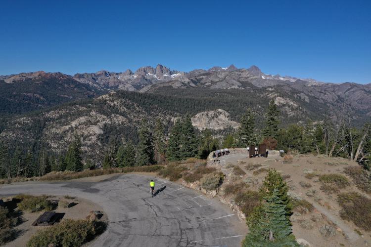
Minaret Vista - climb finish

In the photo above you see the jagged peaks that inspired the name Minaret for the viewpoint also seen in the photo.  

The peaks were named in 1868 by the California Geographical Survey, which reported: "To the south of Mount Ritter are some grand pinnacles of granite, very lofty and apparently inaccessible, to which we gave the name of 'the Minarets.” Wikipedia 

The Minarets

View west of the Minarets near the top of the climb.

Same location as the photo above.

The Minarets are located in the Ritter Range which is a sub-range of the Sierra Nevada Mountains.  The area is more popular for winter sports at Mammoth Mountain Ski Area, but cycling is also a worthy alternative as well as a trip to Devils Postpile National Monument which is located 1 ½ miles west of the start of the Minaret West bike climb.  

Start the climb by riding northwest up Hwy 203 from its junction with Lake Mary Road, Mammoth Lakes


Pass by Mammoth Ski Resort at mile 4.2

Minaret Vista - finish.

That’s a wrap!!

DEVIL’S POSTPILE NATIONAL MONUMENT

“Established in 1911 by presidential proclamation, Devils Postpile National Monument protects and preserves the Devils Postpile formation, the 101-foot high Rainbow Falls, and pristine mountain scenery.  The formation is a rare sight in the geologic world and ranks as one of the world's finest examples of columnar basalt. Its columns tower 60 feet high and display an unusual symmetry.” NPS Devils Postpile.