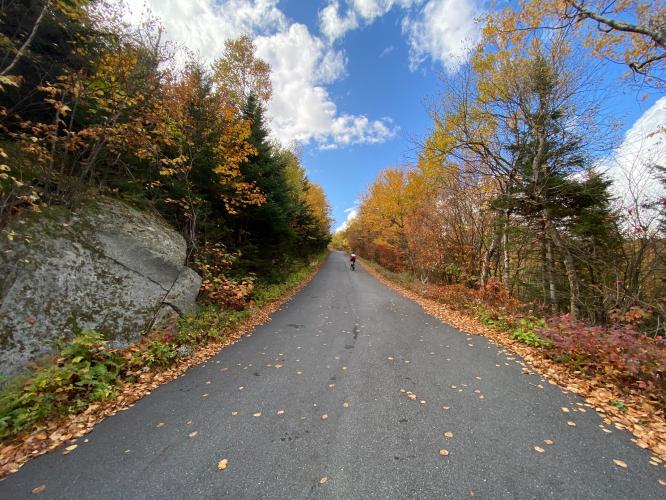
Mt. Ascutney Bike Climb - PJAMM Cycling

8.6
FIETS
3.5 mi
DISTANCE
2,279 ft
GAINED
12.4 %
AVG. GRADE

FULL CLIMB STATS

Page Contributor(s): John Summerson, The Complete Guide to Climbing (By Bike), 2nd Edition

INTRO

Mount Ascutney is the #74 ranked US bike climb.  This very steep climb is through Mount Ascutney State Park near Windsor, Vermont.  The climb is surrounded by trees the entire route until the top, but is a jewel particularly during fall colors.  Be sure to visit the Cornish-Windsor covered bridge 5.2 miles from the climb start. 

"Another legendary New England ascent, [this] is an extremely steep and difficult climb...There are extended ramps of 15% grade and except for a stretch in its upper end the entire climb is steep.  You will not get a break over the first two miles through multiple tight switchbacks.  You are also riding within a thick tunnel of trees here which adds to the sense of foreboding..." (This quote provided with the approval of John Summerson from his book The Complete Guide to Climbing (by Bike), 2nd Edition, pg. 86.)
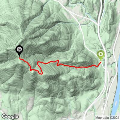
Mt. Ascutney gets its #74 US Top Bike Climb ranking because of its extreme gradient.  The climb averages 12.2%, has 0 descent, and has 1.9 miles (53%) in the 10-15% gradient range and 0.7 miles (20%) at 15-20%.  Although the GPS readings do not pick it up when transferred to the map and profile grid, my Garmin read 21% at one point on the climb (see photo in "Full Summary").  The steepest quarter-mile is 17% and there is one full mile that averages 14.9%. 

See more details and tools regarding this climb's grade via the “Profile Tool” button.
Roadway: Good condition, but be cautious of roadway debris on the descent.
 
Traffic: Mild and slow moving - not a problem.

Parking: Across the street form the park entrance and climb start - Map; Street View

Fee:  $4 to enter on bike in 2020. 
I needed the following gearing:  Compact (34t) chainring + 38t rear cog. 
Before heading out on any cycling adventure check out our Things to Bring on a Cycling Trip and use our interactive check list to ensure you don't forget anything.
This climb has stunning surroundings during fall colors (see photos in "Full Summary").  Consider staying in nearby Windsor, Vermont, where there are also lots of options for vacation rental homes, including many very cool cabins.

ROUTE MAP

MEMBER RATING

Difficulty: Strenuous
3.5
Road
5
Traffic
4
Scenery

CURRENT WEATHER

PJAMM TRIPS ADVENTURE STARTER BUNDLES

Check out PJAMM Adventure's prepackaged (self-guided) cycling trips. They will help you plan, document and conquer your next adventure.
ALL TRIPS
Browse all of our prepackaged trips and find your next adventure!
Northeast Fall Colors
United States (MA,ME,NH,NY,VT)
24 ROUTES
37 POIs
ROUTE STATS (TOTAL)
98
mi
DISTANCE
35,116
ft
ELEV. GAIN

NEARBY CLIMBS (0) RADIAL PROXIMITY

FROM
No Climbs Found

MEMBER REVIEWS & COMMENTS

Let us know what you thought of this climb. Signup for our FREE membership to write a review or post a comment.
Already have an account?

Jun 25, 2022
Highest grade my garmin 830 showed was 16percent. The grade was pretty relentless with only a few very short respites along the way until about mile 2.75 where it got easier until about mile 3.5 where it gets steep again until the end. I found it harder than Mt Greylock (north side) even though strava has that as an HC climb while this one is a Cat-1.
Jun 14, 2022
difficulty: Strenuous
scenery: 4
traffic: 5
road: 4
Jun 14, 2022
scenery: 4
traffic: 5
road: 4
Tough climb right off the start. Immediately on a 12-14% grade after the toll booth (Was free the day I rode) Road condition seems great going up at 4-5mph but it’s pretty rough in places on the descent. The descent is tough to go slow enough, the drastic grade can get you outta control quickly. Good brakes in good condition are a must. Overall a strenuous climb but it’s over fairly quick. One note - turn auto pause off on your garmin or you will become very annoyed.
May 27, 2021
difficulty: Strenuous
scenery: 4
traffic: 5
road: 3
May 27, 2021
scenery: 4
traffic: 5
road: 3
I did this climb the day after the Mt Washington Auto Road Bicycle Hillclimb. Had to stop and walk several times due to fatigue. While Mt. Washington has several "less steep" sections, Ascutney is pretty continuous with very little respite.
ROUTE MAP
PROFILE TOOL
Route Data
S.G. (%)
hide
Segment Data
hide

Climb Profile Not Found
CLIMB SUMMARY

Cycling Mt. Ascutney, Vermont - road sign reads "Welcome To Vermont, the Green Mountain State", surrounded by dense green folliage

Cycling Mt. Ascutney , Vermont

One of the steepest and hardest bike climbs in the northeast.

Ride only 3.5 miles but gain 2,280’ to 2,796’ elevation at 12.4%.

“Another legendary New England ascent, Mount Ascutney is an extremely steep and difficult climb located in eastern Vermont near the New Hampshire border.  There are extended ramps of 15% grade and except for a stretch early within its second half the entire climb is steep.” (This quote is provided with the approval of John Summerson from his book, The Complete Guide to Climbing (by Bike) in the Northeast, pg. 178.)

Climb summary by PJAMM’s John Johnson.

Before heading to Vermont on your cycling adventure, be sure to rely on our list of Things to Bring on a Cycling Trip, and use our interactive checklist to ensure you don't forget anything.

Cycling Mt. Ascutney, Vermont - photo collage, PJAMM Cycling logo in corner, mile marker 3 sign, green and yellow sign for Mt. Ascutney State Park Entrance, greenery along the roadway, view looking down of greenery and mountains

Begin the climb by riding into Mt. Ascutney State Park.

Ride away from the New Hampshire border, a stone's throw from the start.

Our July 2015 start.

Cycling Mt. Ascutney, Vermont - climb's start at the Mt. Ascutney State Park Entrance, bike parked in front of sign, fall foliage, PJAMM Cycling logo in corner

Our Fall 2020 start

Mt. Ascutney, #74 on the Top US 100 Climb list, is an extremely steep, albeit brief, climb to the parking lot at the end of Mt. Ascutney State Park Road.  At 12% and 3.5 miles, this is the shortest climb in the first 60 of the Top 100 U.S. Climbs -- you get your bang for your climbing buck on this one!  The other Top 100 climb within 200 miles of this climb are #3 Mt. Washington, New Hampshire, #18 Mt. Equinox, Vermont, #41 Whiteface Mt, New York, and #87 Burke Mt, Vermont.

Cycling Mt. Ascutney, Vermont - photo collage, PJAMM Cycling logo in corner, densely forested one-lane roadway

The roadway is bordered by thick forest nearly all of the climb. 

The Mount Ascutney State Park Road bike climb begins near Windsor, Vermont (population 3,553, 2010; elevation 1,066’).  Windsor is known as “the Birthplace of Vermont.”  Visit the Old Constitution House while in the area. Mount Ascutney is part of the Coolidge mountains, a subrange of the Appalachians mountain range.

   Cycling Mt. Ascutney, Vermont - Garmin device reading 21% grade

Steeeeeeep!

Cycling Mt. Ascutney, Vermont - PJAMM Adventure app showing climb grade and profile

Rarely do we see such colors on our App’s gradient profile . . .

. . . . purple = 20%+ !!

Drive through and across one of the top covered bridges in New Hampshire and Vermont.  The Cornish-Windsor Covered Bridge is a two span timber Town lattice-truss covered bridge.  The bridge was built in 1866 and is 449 feet long and 24 feet wide. It is about a five mile drive from the beginning of the Mt. Ascutney climb and connects Cornish, New Hampshire with Windsor, Vermont.

OVERLOOK

Cycling Mt. Ascutney, Vermont - photo collage, PJAMM Cycling logo in corner, lookout viewpoint of green trees, mountains in the distance, trail sign reads "Shelter", small shelter among evergreen trees

Overlook entrance is 1.7 miles up from the climb start.  

Cycling Mt. Ascutney, Vermont - the path to the overlook during fall foliage time, bike parked at various points along the way

Path and overlook during fall colors.

MT. ASCUTNEY DURING FALL COLORS

Cycling Mt. Ascutney, Vermont - two PJAMM Cyclists stand on low stone retaining wall with their bikes surrounded by bright fall colors

Leaf peeping time -- stunning scenery!

Cycling Mt. Ascutney, Vermont - fall foliage on lower half of the climb

First half of the climb.

Photos clockwise from top left are arranged lower elevation to higher elevation.

Note in the two fall photo collages how the colors change from lower to higher elevation. 

Cycling Mt. Ascutney, Vermont - fall foliage on upper half of the climb

Second half of the climb.

CORNISH, NH - WINDSOR, VT COVERED BRIDGE

Cycling Mt. Ascutney, Vermont - the Cornish to Windsor historical covered bridge during fall foliage season

Cycling Mt. Ascutney, Vermont - the Cornish Covered bridge as seen from above during fall foliage season

Photo left: Windsor Cornish Covered Bridge, as seen from Mt. Ascutney.

Be sure to include the Cornish-Windsor covered bridge on your list when you climb Mt. Ascutney.  The bridge is 4.3 miles from the start of the Mt. Ascutney climb (map).

Cycling Mt. Ascutney, Vermont - bike parked in front of historical sign with information on Cornish-Windsor covered bridge

This version of the bridge was constructed in 1866 and is the longest single span wooden covered bridge in the United States at 449.  The bridge crosses the Connecticut River and the New Hampshire/Vermont border between Cornish (NH) and Windsor (VT).

Cycling Mt. Ascutney, Vermont - cyclist crossing the Cornish-Windsor covered bridge

Cycling Mt. Ascutney, Vermont - views of the Cornish-Windsor covered bridge from afar and above during fall foliage season

MT. ASCUTNEY BICYCLE HILL CLIMB

There was a bicycle race up Mt. Ascutney from 1999 to 2014, which went on a hiatus from 2015-2018.  The race began again in 2019 but was not held to our knowledge in 2020 due to the pandemic.  For those searching for the race, Google Mt. Ascutney Bicycle Hillclimb.

That’s a wrap!!

Access to full Climb Summary requires a PJAMM Cycling PRO Membership!

It takes less than a minute to sign up & with your PRO membership you can:
  • Rate climbs, post comments and share your experiences on any of our climb pages
  • Create bucket lists of climbs & mark the dates you complete them
  • Weather data for all climbs - Start & Finish
  • Upload photos to your member page to customize your PJAMM Cycling experience
  • Utilize all of our interactive tools - Profile & Routes in Area
  • Download climb route .gpx files
LEARN MORE
SIGN UP

Already have an account? LOG IN HERE