16.3
PDI
5.5 mi
DISTANCE
2,402 ft
GAINED
7.7 %
AVG. GRADE
FULL CLIMB STATS
Page Contributor(s): Ties Arts, Netherlands
INTRO
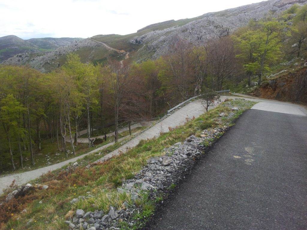
Until a few years before the Vuelta a España first came here in 2017, there was no road over this ridge at all. Getting from Bustablado to Calseca, on the far side, meant a drive of nearly 50 km; the new lane cut it to about 10. It's a farm lane in all but name - one car wide and pointed straight up the slope.
The race loved it. In 2017 Stefan Denifl crossed the line first from the break - a win later struck from the record after his doping ban, which leaves Alberto Contador as the stage winner - while Chris Froome, in the leader's jersey, lost 42 seconds to Vincenzo Nibali on the ramps. Two years later the Vuelta came back and Tadej Pogačar, riding his first Grand Tour, went clear with Primož Roglič and won at the top.
From Bustablado our route is 8.8 km (5.5 mi) with 732 m (2402 ft) of climbing at 7.7%. The first 2 km average close to 11%, a short flat stretch follows, and then from km 3 to about km 6.6 the road holds 10 to 14% kilometer after kilometer. Over shorter stretches it's much steeper: the worst ramps reach 25 to 28%, and some of them are ribbed concrete. The steepest full kilometer is 13.7%.
Above the trees it's open pasture, limestone outcrops and stone huts, with Pasiega cattle grazing beside the road and, as often as not, low cloud. On a clear day you can see down to the sea at Santander. The Vuelta finished at the monument to the Pasiega cow, about 7.4 km up; our route carries on past it for another 1.3 km, dipping and then climbing again to finish at 910 m on the road to Calseca.
PLAN YOUR ROUTE
 We've partnered with Sherpa-Map.com to bring you the best route planning tool. With a PRO Membership you can use this climb as a reference when creating your route.
Our route climbs 8.8 km (5.5 mi) from 241 m (791 ft) in Bustablado to 910 m (2986 ft), gaining 732 m (2402 ft) at an average of 7.7%. The steepest kilometer averages 13.7% and the steepest 500 m 15.7%; individual ramps reach about 28%.
Km 0-2: straight into it - around 9% for the first kilometer and 12% for the second, on a narrow lane out of the village.
Km 2-3: a near-flat stretch. Use it.
Km 3-6.6: the hard part. Every kilometer is 10 to 14%, with the steepest kilometer around km 4-5 and the 25% and steeper ramps scattered through it.
Km 6.6-8.8: over the top, a gentle downhill past the Vaca Pasiega monument at km 7.4, then a last kilometer at 2.5 to 7% to our finish.
Roadway: Paved, but rough. It's a single-lane mountain road: coarse, patched asphalt with loose gravel along the edges lower down, ribbed concrete slabs on some of the steepest ramps, and a wider, smoother stretch around the monument. Take the descent slowly - a wet concrete ramp at 20% or more is no place to be braking hard, and the cloud can come down quickly.
Traffic: Very light - mostly farm vehicles and a few visitors driving up to the monument. There's no room to pass on the steep sections, so watch the blind corners, and expect cattle near the road above the trees.
Parking: Park in Bustablado near the start, leaving room for tractors and farm traffic. There's a small open area with a picnic spot and viewpoint at the Vaca Pasiega monument if someone is meeting you at the top.
Gear: Bring your lowest gear, and then wish you had one lower. A compact with a 34-tooth or bigger cog is the sensible minimum for ramps near 28%. If you haven't ridden pitches like this before, practice getting going again on a steep slope - stalling on a concrete ramp and clipping back in is the hardest part of the day. Good brakes and fresh pads matter on the way down.
Provisions: Arredondo, a few kilometers down the valley, is the place for a bar or a shop - don't count on anything in Bustablado itself. Above the last houses there's no water or shop until you're back down, so leave with two full bottles.
Before heading out on any cycling adventure check out our Things to Bring on a Cycling Trip and use our interactive check list to ensure you don't forget anything.
Arredondo, a few kilometers down the valley, is the nearest bigger village and a good base for the upper Asón, with rural houses to rent and a handful of restaurants. The Puerto de Alisas starts there too, if you want a second, much gentler climb.
This is cave country: the Cueto-Coventosa system under these hills is one of the great cave systems of northern Spain. Just to the east, the Collados del Asón natural park holds the source of the Asón, which pours out of a cliff as a waterfall - worth the short drive.
The Pas valleys are dairy country, and the Pasiega cow on the monument is the reason. Look for sobaos and quesadas, the butter sponge cake and the soft, cheesecake-like dessert made with the local milk - the right way to refuel after this one.
ROUTE MAP

MEMBER RATING
CURRENT WEATHER
PJAMM TRIPS ADVENTURE STARTER BUNDLES
Check out PJAMM Adventure's prepackaged (self-guided) cycling trips. They will help you plan, document and conquer your next adventure.
NEARBY CLIMBS (0) RADIAL PROXIMITY
FROM No Climbs Found
MEMBER REVIEWS & COMMENTS
Let us know what you thought of this climb. Signup for our FREE membership to write a review or post a comment.
Already have an account?
LOG IN HERE