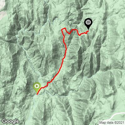
11.8
PDI
3.9 mi
DISTANCE
1,671 ft
GAINED
7.8 %
AVG. GRADE
FULL CLIMB STATS
INTRO
This 3.9 mile bike climb is located in CA, USA. The average gradient is 7.8% and there is a total elevation gain of 1,671 ft, finishing at 5,350 ft.
Use the profile tool, route map, and weather forecast to conquer this cycling climb.
Use the profile tool, route map, and weather forecast to conquer this cycling climb.
PLAN YOUR ROUTE
See more details and tools regarding this climb's grade via our interactive Profile Tool.
Information Not Available
If you have any information regarding this climb, we'd like to hear from you. Click the CONTRIBUTE button to share your thoughts with us.
Information Not Available
If you have any information regarding this climb, we'd like to hear from you. Click the CONTRIBUTE button to share your thoughts with us.
Before heading out on any cycling adventure check out our Things to Bring on a Cycling Trip and use our interactive check list to ensure you don't forget anything.
Information Not Available
If you have any information regarding this climb, we'd like to hear from you. Click the CONTRIBUTE button to share your thoughts with us.
ROUTE MAP
MEMBER RATING
CURRENT WEATHER
PJAMM TRIPS ADVENTURE STARTER BUNDLES
Check out PJAMM Adventure's prepackaged (self-guided) cycling trips. They will help you plan, document and conquer your next adventure.
NEARBY CLIMBS (0) RADIAL PROXIMITY
FROM No Climbs Found
MEMBER REVIEWS & COMMENTS
Let us know what you thought of this climb. Signup for our FREE membership to write a review or post a comment.
Already have an account?
LOG IN HERE
golmstead
Deceptively difficult. I rode this with a friend of mine in December, several years ago. Started in Pine Valley, with the goal of riding this up to the general store, then back down Sunrise Highway to the car. Two things of note: there are a couple places where the road pitches up to >20%, right out of nowhere. I can't remember straining so hard in first gear. Second, because the road can turn to gravel road and it's part of a larger network of roads, it's easy to make a wrong turn. Use a computer to help with navigation. Lastly, after we got on the main road to the General Store there was till snow on the ground, but we were warm from the exercise. When we got to the store the thermometer showed it was about 40º. And we didn't have thermal gear for the descent. We bought some newspaper and gloves for the descent but froze anyway. Be sure to plan for all the weather you expect to see along the way.
cbockus
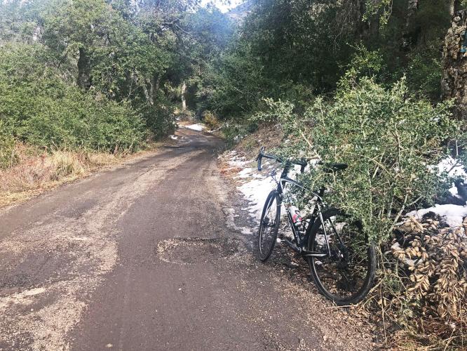
I came down Pine Creek while doing the Sunrise Highway loop on January 9th, 2022. I was on 28mm tubeless road tires. I picked up four punctures that, fortunately, self-sealed. Rough road, lots of loose rock, large potholes and a few muddy crossings. Could imagine climbing on road tires in the current condition. But, what a beautiful area and a beast of climb.
MSchube
This climb is a beast. As an SD local I've done my share of area climbs but this one just punches you in the face. Multiple 20%+ ramps and switchbacks. I think 24% for about 300m is the steepest I had on my Wahoo. Three of us rode it back in October. Started in Alpine, came up Viejas Grade. Was not mentally prepared for the steepness, as the profiles don't do this one justice. Gates were open (usually closed) but no car traffic (plenty of people camping though) and just some mountain bikers so we had it pretty much to ourselves. Road surface is pretty beat up, worse than nearby Kitchen Creek, but still doable. Not a lot of cover as others mentioned, and no places to stop (once you get to sunrise you can find water but it's still a ride north or south to find some) so would not recommend as a hot weather climb.
GAJ21
As a San Diego local I've spent a fair amount of time exploring the local climbs. Pine Valley is a brutal hidden gem that get's far less traffic from cyclists than it probably should.
The undulating steep ramps often approach of break 20% while the eroding road surface also becomes a unique challenge. This climb begins in a wooded campground that eventually gives way to an open hillside ascent that offers no shelter from the sun just as it begins to really get steep. Eventually, you again find yourself among pine trees as you approach the peak of the climb which is nestled to the north of Mt Laguna's peak.
Be wary of the road condition after passing the second forestry gate near the top. The road begins to undulate with some fast downhill sections that send you into gravelly corners and potholes. It should also be noted that it can get very hot out in these hills and you won't be able to refuel for quite a few miles after the summit.