Yarnell South Bike Climb - PJAMM Cycling

9
PDI
7.3 mi
DISTANCE
1,819 ft
GAINED
4.7 %
AVG. GRADE

FULL CLIMB STATS

Page Contributor(s): Bruce Hamilton, La Quinta, CA, USA

INTRO

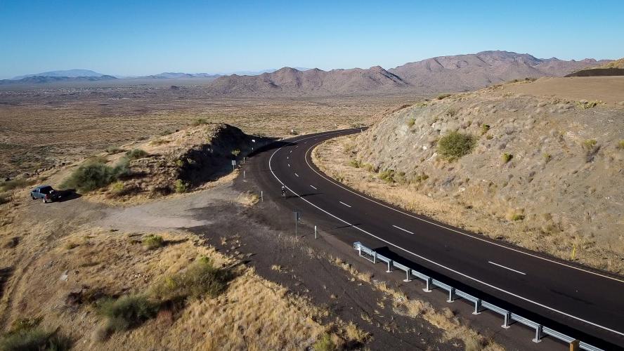
A fun, scenic climb with a fresh roadway (as of 2021) and excellent views of a vast desert valley.

See more details and tools regarding this climb's grade via our interactive Profile Tool.
Parking:
The best place to park is either in Congress, or at the Granite Mountain Hotshots Memorial Park, actually halfway down the climb (this is a split road, so you will have to drive about 3/4 of the way up, make a u-turn, and drive back down to the memorial's parking lot)

Roadway:
As of the last time we did this climb (winter of 2020), there was a freshly paved roadway.  
Traffic is fast and moderate, but there is a good visibility and a very wide shoulder for most of the climb. 
Information Not Available

If you have any information regarding this climb, we'd like to hear from you. Click the CONTRIBUTE button to share your thoughts with us.

Before heading out on any cycling adventure check out our Things to Bring on a Cycling Trip and use our interactive check list to ensure you don't forget anything.
Information Not Available

If you have any information regarding this climb, we'd like to hear from you. Click the CONTRIBUTE button to share your thoughts with us.

ROUTE MAP

MEMBER RATING

Not Yet Rated
-
Road
-
Traffic
-
Scenery

CURRENT WEATHER

PJAMM TRIPS ADVENTURE STARTER BUNDLES

Check out PJAMM Adventure's prepackaged (self-guided) cycling trips. They will help you plan, document and conquer your next adventure.
ALL TRIPS
Browse all of our prepackaged trips and find your next adventure!
Arizona: Cycling and Spring Training
United States (AZ)
17 ROUTES
48 POIs
ROUTE STATS (TOTAL)
360.3
mi
DISTANCE
33,516
ft
ELEV. GAIN
Arizona: Mt. Lemmon
United States (AZ)
11 ROUTES
28 POIs
ROUTE STATS (TOTAL)
62.4
mi
DISTANCE
16,765
ft
ELEV. GAIN
The American Southwest
United States (AZ,NM,UT)
18 ROUTES
27 POIs
ROUTE STATS (TOTAL)
215.4
mi
DISTANCE
34,866
ft
ELEV. GAIN

NEARBY CLIMBS (0) RADIAL PROXIMITY

FROM
No Climbs Found

MEMBER REVIEWS & COMMENTS

Let us know what you thought of this climb. Signup for our FREE membership to write a review or post a comment.
Already have an account?
ROUTE MAP
PROFILE TOOL
Route Data
S.G. (%)
hide
Segment Data
hide

Climb Profile Not Found
CLIMB SUMMARY

Cycling Yarnell South, Yavapai County, Arizona

Ridge 7.3 miles gaining 1,817’ at 4.7% average grade.

Climb summary by PJAMM’s Bruce Hamilton.

This ride starts just outside the town of Congress, AZ (pop. 4,821 in 2010) about 80 miles northwest of Phoenix.

Ghost town of Congress

Photo:  Congress Facebook page

The climb is a pretty consistent five percent grade over about eight miles.


Consistent 5% grade 🚴😊

The road has a wide shoulder and uphill and downhill traffic are separated. This road goes to the town of Yarnell where in 2013 there was a deadly wildfire where many firefighters were suddenly trapped by flames. Halfway up the climb is a state park created to commemorate the firefighters.  We strongly recommend taking the Granite Mountain Hotshots Memorial Trail hike of 6 miles round trip if you are in the area.  We did the climb and the hike on the same visit – both are recommended.

This is the memorial site where 19 Prescott Granite Mountain

 Hotshots died fighting the Yarnell Hill Fire fire on June 30, 2013.

This climb is not difficult by PJAMM standards but is a typical southwest desert ride and worth riding if you’re in the area. The descent is fun as the uphill traffic is on a separate road and the shoulder is wide.

Climb begins in Congress, one of the areas ghost towns.

Congress area early circa 1914

Photo:  Wikipedia 

Climb ends in Yarnell (pop. 649 in 2010)

Photo:  Wikipedia

Thank you Bruce!!

Further input from PJAMM’s Sam Lyons:

  • The best place to park is Granite Mountain Hotshots Memorial State Park, a small pull off parking lot with one trailhead that leads up into the mountains. Since the road is separated, right at mile 6 there’s a left turn onto a short road that connects to the other side of the highway. Unfortunately this means that you’ll have to do most of the descent first, then climb back up to Yarnell, then descend back 1.5 miles to your car after you finish.

  • If doing this climb in the late afternoon the descent will point you directly into the sun the entire time

  • A few quaint diners, antique shops and general stores in the town of Yarnell. A nice place to ride around for a bit after doing the climb