
16.8
PDI
13.8 mi
DISTANCE
3,543 ft
GAINED
4.4 %
AVG. GRADE
FULL CLIMB STATS
Page Contributor(s): Ard Oostra, Switzerland
INTRO
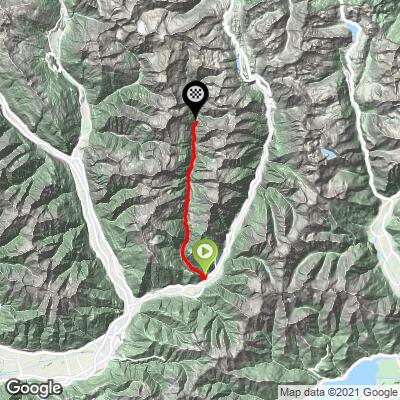
Most people pass the mouth of the Calanca on the A13 to the San Bernardino without a second look. The valley has well under a thousand residents spread along 26 km, no through road, and a cantonal road that simply runs out above the last village. That's the appeal: 22.2 km (13.8 mi) from Grono to the end of the asphalt above Rossa, gaining 1080 m (3,543 ft) at a 4.4% average, with hardly anyone else on it.
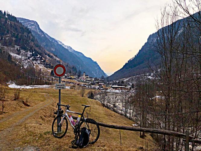
The climbing comes at both ends. The first 3.6 km out of Grono are the hardest sustained work, about 260 m up through hairpins and a tunnel into the valley. After a short drop and a steeper kick near Buseno, the road settles into a long, gentle drag up the valley - 2 to 5% for most of 14 km, past stone villages, sheer rock walls and the Calancasca river. Above Rossa it changes character again: the Via Mont climbs the last 2.4 km at around 9%, finishing with a kilometer at 11.7% that's harder than it looks on paper, and it ends with a view straight back down the whole valley.
The road had a rough 2026, with a debris flow at Pont Nef between Buseno and Arvigo in August - see Roadway & Parking for the current situation before you go.
PLAN YOUR ROUTE
 We've partnered with Sherpa-Map.com to bring you the best route planning tool. With a PRO Membership you can use this climb as a reference when creating your route.
Calanca Valley is 22.2 km (13.8 mi) long and gains 1080 m (3,543 ft) at a 4.4% average, from 320 m (1049 ft) in Grono to 1301 m (4270 ft) above Rossa. About 98 m of descent along the way is climbed back.
Km 0-3.6: about 260 m of climbing (7.3% average) through the hairpins above Grono and the tunnel into the valley; the first 2 km are the steepest, at 10.1% and 8.5%.
Km 3.6-7: a short downhill, then 3.6% and a steep 8.9% kilometer near Buseno before the road levels again.
Km 7-19: the long middle - mostly 2 to 4%, with one kilometer at 5.9% between Arvigo and Selma and a flat stretch near Augio.
Km 19-22.2: 4.9% and 4.8% through Rossa and onto the Via Mont, then 11.7% to the finish.
Steepest sections: 1 km (0.6 mi) at 11.7%; 2 km (1.2 mi) at 9.2%; 5 km (3.1 mi) at 6.2%; 10 km (6.2 mi) at 4.9%.
Roadway: Tarmac from Grono to the finish. The cantonal road is two lanes with a center line through most of the valley, narrowing in the upper villages, and the Via Mont above Rossa is a narrow single-lane road. You need front and rear lights for the tunnel at the entrance to the valley. In 2026, a debris flow on 20 August closed the road at Pont Nef, between Buseno and Arvigo; it reopened on 2 September for daytime traffic only (6:30 to 20:30), one lane at a time under traffic control, and the canton closes the Molina-Arvigo stretch again ahead of heavy rain, as it did on 7-8 October. An emergency bridge and bypass are being built to get around the slide, so check strassen.gr.ch before you set out. In winter, expect ice on the shaded upper road.
Traffic: Light. There's no through traffic - the road ends above Rossa - so it's residents, deliveries and summer visitors. While the Pont Nef works continue, expect short waits at the controlled section.
Parking: There are a few spaces on the right just after the Calanca road leaves the main road at Grono, by the Grono, Bivio Calanca post bus stop. From the A13, take the Roveredo exit (38) and head north to the Calanca junction.
Gear: Most of the valley is gentle enough for any gearing, but you'll want something low for the hairpins out of Grono and that last kilometer above Rossa - a compact with a 30 or 32 cog is plenty. Don't forget lights for the tunnel.
Provisions: Stock up before you leave the Mesolcina. In the valley, the Campagnola near Buseno and the Germinia in Arvigo are the places to stop; the upper villages are tiny, and we wouldn't count on finding anything open beyond Arvigo.
Before heading out on any cycling adventure check out our Things to Bring on a Cycling Trip and use our interactive check list to ensure you don't forget anything.
Give the side terraces an hour. From Arvigo and Selma, small cable cars climb to Braggio (1320 m) and Landarenca (1280 m), stone-and-wood hamlets with no road at all. The Baroque parish church in Santa Domenica is the finest building in the valley, Augio has the early-1900s Hotel Cascata with its hall of mirrors, and between Buseno and Arvigo you pass the beola stone quarries, worked for about a century. Cauco made its name carving soapstone in the 1700s.
Santa Maria in Calanca, with its 13th-century tower and a parish church first recorded in 1219, sits on a terrace above the valley mouth, reached by a side road via Castaneda - a good short add-on on the way home. For Roveredo and the brutal Alpe di Cadinello see that page, and Passo San Bernardino starts up the Mesolcina at Soazza.
ROUTE MAP
MEMBER RATING
CURRENT WEATHER
PJAMM TRIPS ADVENTURE STARTER BUNDLES
Check out PJAMM Adventure's prepackaged (self-guided) cycling trips. They will help you plan, document and conquer your next adventure.
NEARBY CLIMBS (0) RADIAL PROXIMITY
FROM No Climbs Found
MEMBER REVIEWS & COMMENTS
Let us know what you thought of this climb. Signup for our FREE membership to write a review or post a comment.
Already have an account?
LOG IN HERE
