
45
PDI
5.6 mi
DISTANCE
4,047 ft
GAINED
13.5 %
AVG. GRADE
FULL CLIMB STATS
Page Contributor(s): Jaime Tolentino, Sunnyvale, CA, USA (El Salvador)
INTRO
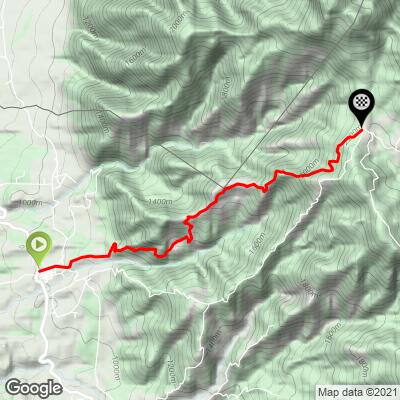
Rio Chiquito is a short, brutally steep climb in El Salvador's Chalatenango Department - 5.6 miles and 4,047 ft of gain at a 13.54% average grade, finishing at 7,242 ft in the canton of Rio Chiquito, a small mountain community on the road toward Cerro El Pital, El Salvador's highest point. PJAMMer Jaime Tolentino, who first documented the climb, rates it the hardest bike climb in El Salvador and all of Central America - the numbers back him up: the steepest quarter-mile averages nearly 24%, with individual pitches over 30%.
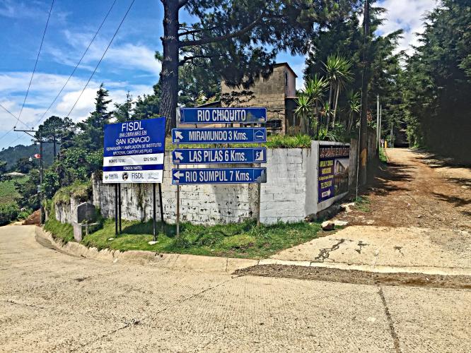
The road climbs out of San Ignacio, a small town on the Ruta Troncal del Norte near La Palma, and follows local Route 509 up into the Chalatenango highlands - the same corridor used by public transit vans and pickups shuttling visitors toward El Pital, so it's a genuinely populated, regularly traveled road rather than a remote track. The upper reaches of this range are known within El Salvador for cool, misty weather that can feel almost alpine by Central American standards - a striking contrast to the tropical heat most riders will have started the day in.
Rio Chiquito canton, at the top of this climb, marks the last reliably paved stretch before the road continues on toward El Pital as a rougher dirt track - so this climb captures the ride-able portion of the ascent. Given the extreme, sustained grade, low gearing matters more here than raw fitness; take the descent seriously too, since it's fast, narrow, and can be shrouded in fog near the top.
PLAN YOUR ROUTE
 We've partnered with Sherpa-Map.com to bring you the best route planning tool. With a PRO Membership you can use this climb as a reference when creating your route.
 Rio Chiquito's 13.54% average is unusually steep even by Central American standards, and it's a genuinely uneven climb rather than a steady grind - the steepest quarter-mile averages nearly 24%, and short pitches exceed 30% in places. There's essentially no flat or downhill recovery along the way; expect the grade to stay in double digits for almost the entire 5.6 miles, which is what earns this climb its reputation as the hardest in the country.
Roadway: The climb from San Ignacio to Rio Chiquito canton is mostly paved, with reports of cobblestone (empedrado) sections through some of the steepest switchbacks - manageable on a road bike in dry conditions. Rio Chiquito canton itself marks the last reliably paved point; beyond it, the road continues toward Cerro El Pital as rougher dirt track that's outside the scope of this climb.
Traffic: Light but real - Route 509 carries local pickups and a public transit run between San Ignacio and Rio Chiquito, plus tourist traffic heading up toward El Pital, one of El Salvador's most-visited natural attractions.
Parking: Stage in San Ignacio's central park, where the road up to Rio Chiquito begins; the town has basic services (shops, food) before you start.
Given the road is mostly paved, a standard road bike works, but gearing matters far more than tire choice on this one - with a 13.5% average and pitches well into the 20s and 30s, a compact or triple crankset with a wide-range cassette makes the difference between riding and walking.
Carry water; there's little in the way of services once you leave San Ignacio, and El Salvador's tropical heat lower down gives way to a noticeably cooler, sometimes misty climate as you gain elevation.
Before heading out on any cycling adventure check out our Things to Bring on a Cycling Trip and use our interactive check list to ensure you don't forget anything.
San Ignacio sits on the Ruta Troncal del Norte a few minutes from La Palma, a well-known artisan town famous for its painted crafts, and both make reasonable bases for this climb. The highlands above Rio Chiquito, toward Cerro El Pital, are known within El Salvador for unusually cool, misty weather - a real change of pace from the coast and lowlands - so pack a layer even though you're only a few thousand feet up.
As with rural travel in El Salvador generally, check current government travel advisories before your trip; San Ignacio-Rio Chiquito itself is a well-traveled, regularly serviced paved corridor rather than a remote backcountry road.
ROUTE MAP
MEMBER RATING
CURRENT WEATHER
PJAMM TRIPS ADVENTURE STARTER BUNDLES
Check out PJAMM Adventure's prepackaged (self-guided) cycling trips. They will help you plan, document and conquer your next adventure.
NEARBY CLIMBS (0) RADIAL PROXIMITY
FROM No Climbs Found
MEMBER REVIEWS & COMMENTS
Let us know what you thought of this climb. Signup for our FREE membership to write a review or post a comment.
Already have an account?
LOG IN HERE
