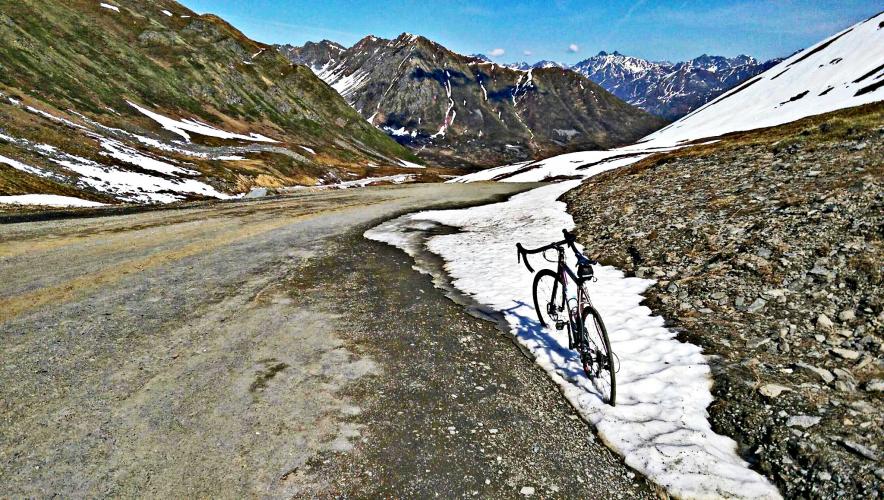
![]()
Cycling Hatcher Pass, Alaska, USA
Ride 11.9 miles gaining 3,210’ at 5% average grade
Photo: Bryant Robbins, Palmer, AK, USA
![]()
This exceptional Alaskan bike climb begins 8 miles northwest of Palmer (pop. 7,306, 2018). If you are in the area, be sure to visit Independence Mine State Historical Park (right at the last hairpin at mile 10.5)
![]()
Climb summary by Bryant Robbins.
The climb can begin from several locations. The true bottom of the climb would be to start in the town of Palmer.
![]()
After a short sharp climb from town on the usually busy Glenn Hwy, turn left on Palmer Fishhook Rd. From here there are 6.8 miles of mild grades until you reach the Wasilla Fishhook intersection where the climb begins in earnest. A store at this intersection makes a good place to park (and get an ice cream cone) if you only want to do the main part of the climb. This is where the mapped route starts. From here it is 11.9 miles to the top. Another alternative starting point is the parking lot just across the Little Susitna River bridge, 1.7 miles further up the road. There are two possible summits for this climb. The ride to the end of the road at the Independence Mine State Park is completely paved, while the road to the top of Hatcher Pass is gravel for the last 1.5 miles. The route and profile shown are for Hatcher Pass. If you prefer to stay on pavement and go to the Independence Mine continue straight on the pavement at mile 10.43 rather than turning left on the gravel. The entire second half of this climb is a nice challenge with steep ramps. The gravel section to the top of the pass has ramps above 16%.
![]()
![]()
Visit the Palmer Museum of History and Art while you are in town.
Photo from Roadtrippers.com
PJAMM’s Palmer contributors Bryant and Jill Aho advise that the Collections Manager at the museum, Richard Estelle, is a wonderful storyteller and it is worth the time to visit the museum if you are visiting the Palmer area.
![]()
723-799 S. Valley Way, Palmer, AK; (907 746-7668 (located at the same address as the museum)
As with any climb in Alaska, beware the weather:
![]()
USClimateData.com
June and the first half of July are typically the best times to ride in Alaska. An added bonus is that it never gets dark during that time of the year (for example in mid-July in Anchorage sunrise is around 3 a.m. and sunset around 11 p.m.).

 We've partnered with Sherpa-Map.com to bring you the best route planning tool. With a PRO Membership you can use this climb as a reference when creating your route.

