23.1
PDI
10.2 mi
DISTANCE
3,698 ft
GAINED
6.8 %
AVG. GRADE
FULL CLIMB STATS
INTRO
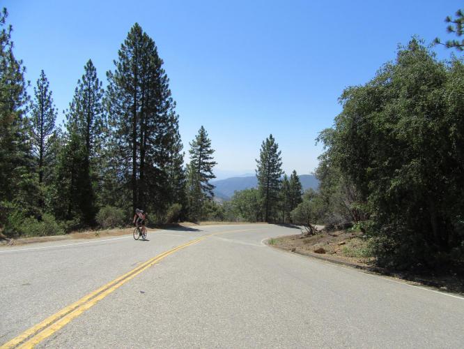
This is the preferred route to the high point of Hwy 168 on the way to Shaver Lake. The first 7 miles are on a two lane road that is in good shape and little traveled. We begin the climb just past Tollhouse where the road begins to bend right. This climb is quite challenging and is best ridden early in the day, before the heat appears.
"Tollhouse Road is a big climb toward high mountains in central CA. A variable grade makes this one a bit tougher than its statistics suggest. The start is shallow and then you enter the small berg of Tollhouse where the grade picks up and becomes more variable. Once beyond town the grade picks up again along with the scenery. There are several tight switchbacks along this section..." (This quote presented with the approval of John Summerson from The Complete Guide to Climbing by Bike in California, p 147)
PLAN YOUR ROUTE
See more details and tools regarding this climb's grade via our interactive Profile Tool.
Information Not Available
If you have any information regarding this climb, we'd like to hear from you. Click the CONTRIBUTE button to share your thoughts with us.
Information Not Available
If you have any information regarding this climb, we'd like to hear from you. Click the CONTRIBUTE button to share your thoughts with us.
Before heading out on any cycling adventure check out our Things to Bring on a Cycling Trip and use our interactive check list to ensure you don't forget anything.
Information Not Available
If you have any information regarding this climb, we'd like to hear from you. Click the CONTRIBUTE button to share your thoughts with us.
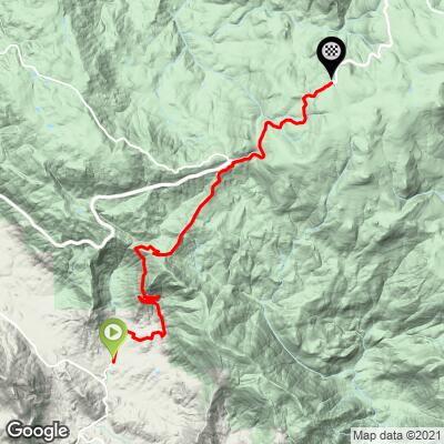
ROUTE MAP
MEMBER RATING
CURRENT WEATHER
PJAMM TRIPS ADVENTURE STARTER BUNDLES
Check out PJAMM Adventure's prepackaged (self-guided) cycling trips. They will help you plan, document and conquer your next adventure.
NEARBY CLIMBS (0) RADIAL PROXIMITY
FROM No Climbs Found
MEMBER REVIEWS & COMMENTS
Let us know what you thought of this climb. Signup for our FREE membership to write a review or post a comment.
Already have an account?
LOG IN HERE
lirizar1
The first portion of the climb on tollhouse was very quiet, I only saw two cars on the way up. The longest / steepest section is just before 168. Once I turned right onto 168 the traffic picked up and there is no shoulder for most of the three mile segment. The cars come in waves so you do have some time without any cars but there are a lot of trucks and the road has blind turns so it's not always easy for them to get around. 168 also has road work being done just past the end of the climb where the road becomes one lane for about 1 mile. If only you could get to Shaver Lake bypassing 168!