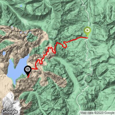
8.5
PDI
14.6 mi
DISTANCE
2,469 ft
GAINED
2 %
AVG. GRADE
FULL CLIMB STATS
Page Contributor(s): Stephen Jones, Olympia, WA, USA
INTRO
This 14.6 mile bike climb is located in WA, USA. The average gradient is 2% and there is a total elevation gain of 2,469 ft, finishing at 4,330 ft.
Use the profile tool, route map, and weather forecast to conquer this cycling climb.
Use the profile tool, route map, and weather forecast to conquer this cycling climb.
PLAN YOUR ROUTE
See more details and tools regarding this climb's grade via our interactive Profile Tool.
Information Not Available
If you have any information regarding this climb, we'd like to hear from you. Click the CONTRIBUTE button to share your thoughts with us.
Information Not Available
If you have any information regarding this climb, we'd like to hear from you. Click the CONTRIBUTE button to share your thoughts with us.
Before heading out on any cycling adventure check out our Things to Bring on a Cycling Trip and use our interactive check list to ensure you don't forget anything.
Information Not Available
If you have any information regarding this climb, we'd like to hear from you. Click the CONTRIBUTE button to share your thoughts with us.
ROUTE MAP
MEMBER RATING
CURRENT WEATHER
PJAMM TRIPS ADVENTURE STARTER BUNDLES
Check out PJAMM Adventure's prepackaged (self-guided) cycling trips. They will help you plan, document and conquer your next adventure.
NEARBY CLIMBS (0) RADIAL PROXIMITY
FROM No Climbs Found
MEMBER REVIEWS & COMMENTS
Let us know what you thought of this climb. Signup for our FREE membership to write a review or post a comment.
Already have an account?
LOG IN HERE
MethowBiker
Note that as of August 2025, the bridge on NF25 is out. Scheduled to be done by November. Check with Gifford Pinchot NF.
I parked at the Iron Creek picnic area, elevation 1500 feet. I ascended via road NF 26. It starts in a clearcut. The first 3 miles are dirt, completely fine on a road bike with 28 or 32 mm tires. Zero traffic. Shaded until those three beastly ramps just before Meta Lake. When you start where I did, the net climb of 4,500 feet is slightly more than that of Col du Tourmalet (and those 3 ramps of 15% are steeper that anything I found on Tourmalet).
Note: the road condition sucks. I advise not wearing sunglasses for the descent as it's dappled shade and undulating "pavement" with potholes. Better on a bike than a car. The descent from Bear Meadows on FS99 and then FS25 are lovely.Not technical except for those potholes.Note that it's often cooler down low than up high, no shade above 3,600 feet (1,100 meters). Also,no water, no cell service. Bring everything you need.