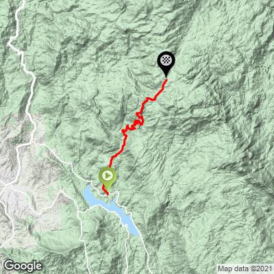
23.4
PDI
11.6 mi
DISTANCE
3,819 ft
GAINED
6.2 %
AVG. GRADE
FULL CLIMB STATS
Page Contributor(s): Lisa Irizarry, NY, NY
INTRO
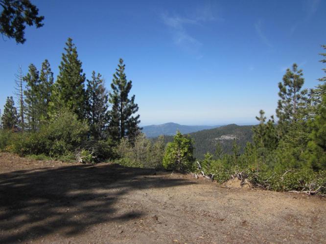
"Cold Springs Summit is reached via Beasore Road very close to Bass Lake west of Yosemite National Park. It climbs through a thick forest along a very solid grade ending at the signed summit (7,308 ft). The grade is very consistent all the way up the hill. It is a scenic climb as well with moss covered pine trees near the top." (This quote is presented with the approval of John Summerson, from his book, The Complete Guide to Climbing (by Bike) in California, pg. 149.)
PLAN YOUR ROUTE
See more details and tools regarding this climb's grade via our interactive Profile Tool.
Information Not Available
If you have any information regarding this climb, we'd like to hear from you. Click the CONTRIBUTE button to share your thoughts with us.
Information Not Available
If you have any information regarding this climb, we'd like to hear from you. Click the CONTRIBUTE button to share your thoughts with us.
Before heading out on any cycling adventure check out our Things to Bring on a Cycling Trip and use our interactive check list to ensure you don't forget anything.
Information Not Available
If you have any information regarding this climb, we'd like to hear from you. Click the CONTRIBUTE button to share your thoughts with us.
ROUTE MAP
MEMBER RATING
CURRENT WEATHER
PJAMM TRIPS ADVENTURE STARTER BUNDLES
Check out PJAMM Adventure's prepackaged (self-guided) cycling trips. They will help you plan, document and conquer your next adventure.
NEARBY CLIMBS (0) RADIAL PROXIMITY
FROM No Climbs Found
MEMBER REVIEWS & COMMENTS
Let us know what you thought of this climb. Signup for our FREE membership to write a review or post a comment.
Already have an account?
LOG IN HERE
mrbranch
Wonderful climb! Remote, low traffic, challenging but not too daunting. The road was well marked with spray paint to identify hazards and hairpin turns. There were plenty of hairpins making for an exciting descent, but also a few milder sections to ease the strain on the brakes and body. Definitely bugs, though. Swarming on the lower section of the climb. Smack ya in the face on the descent. Probably swallowed more than a few. Last, but not least is snow. I was close to the summit, but never made it to the top as there was too much snow on the road. A beautiful sight, though and felt like a climbing achievement to hit impassable snow while my departure point was warm and sunny. Enjoy!
lirizar1
Awesome! Super remote climb with excellent pavement. You are one with nature although that also means lots of bugs in your face the first few miles. Saw one car, one motorcycle and a group of three cyclists on the out and back. Snow started appearing on the road starting 3 miles from the top but you could still get by until a mile left (7,000 ft) and then the road was completely blocked by snow and impassable. Guess I'll have to come back after the snow melts! Highly recommend!