23.9
PDI
10 mi
DISTANCE
3,777 ft
GAINED
7.1 %
AVG. GRADE
FULL CLIMB STATS
INTRO
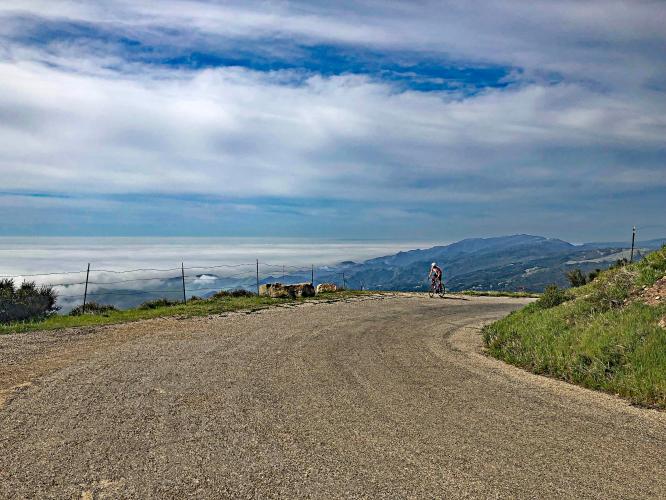
"Refugio Road is a stunning climb into the coast mountains west of Santa Barbara. A very narrow, twisty and variable grade road takes you up the hill, often under a tunnel of trees near the bottom. A steep switchback to the left...several miles in will get your attention as the trees begin to thin. Continuing over a variable grade, at mile 5.2 you reach a junction. From here (turn right...) the road is a true single lane and hugs the cliffside in places. Continuing over a narrow road and a variable grade, the route is exposed for the majority of the 2nd half of the ascent. The steepest climbing is at the very end as there is a double digit grade ramp just before the road dead ends at a cell tower facility." (Quote presented with the approval of John Summerson from The Complete Guide to Climbing (by Bike) in California, pg. 182.)
PLAN YOUR ROUTE
Average grade is 7.1% (7.5% climb only). 54% of the climb is at 5-10% and 19% is at 10-15%. The steepest quarter-mile is 12.7% and steepest mile 11.1%.
See more details and tools regarding this climb's grade via the “Profile Tool” button.
Roadway: Very narrow and rough in many sections as of 2019.
Traffic: Minimal.
Parking: The road is narrow from beginning to end, but there are some spots to pull over and park your vehicle - one such spot is at the start of the climb - Map; Street View.
There are no provisions on this route. The closest food and beverages are in Goleta 13 miles west (map).
Santa Barbara has a mild climate, but be sure to consult the PJAMM "Full Forecast" feature for the time you expect to arrive at the finish to assess what clothing to bring on your ride.
Before heading out on any cycling adventure check out our Things to Bring on a Cycling Trip and use our interactive check list to ensure you don't forget anything.
We have enjoyed riding the climbs out of Solvang and Santa Barbara when we have travelled to this area for cycling trips. Solvang is a very cool Danish town in the area to visit. There are vacation rental options in the area.
See the “Routes in Area” button in the menu above to see what other climbs are in the area.
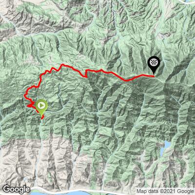
ROUTE MAP
MEMBER RATING
CURRENT WEATHER
PJAMM TRIPS ADVENTURE STARTER BUNDLES
Check out PJAMM Adventure's prepackaged (self-guided) cycling trips. They will help you plan, document and conquer your next adventure.
NEARBY CLIMBS (0) RADIAL PROXIMITY
FROM No Climbs Found
MEMBER REVIEWS & COMMENTS
Let us know what you thought of this climb. Signup for our FREE membership to write a review or post a comment.
Already have an account?
LOG IN HERE
bjosloff


If there has been rain, your'e feet are gonna get wet on some of the bridge crossings. This climb is fantastic and feels so remote with unique views compared to Gibraltar and Painted Cave. The descent is not fun however as the pavement quality and nature of the turns keeps you from building up speed as you can on Gibraltar for example. Also, If you continue past the observatory for just a quarter a mile on the dirt you can get a great view of Lake Cachuma. Worth doing at least once.
Ian.O
Tough climb with a great sense of adventure. Continue on to West Camino Cielo for the best views. It was recently burned by the Alisal fire so it's not as lush as it once was but the road itself was not affected and it's still amazing. The descent is very rough due to the pavement quality and cattle grids-one of those where you thank the heavens it's over rather than enjoying the thrill of the downhill
grock333
FYI, Just rode this climb again 3/24/25 and the roughest parts have been repaved. I find this to be the toughest climb in Santa Barbara area, Very tough first few miles which saps the legs. Stay away from this one on a hot day. Road is pretty bumpy in some places and fine in others, Water crossings can be tricky if raining. Views of ocean and back country are well worth it. Virtually no traffic.
joelmblatt
It was freezing on descent, but that is typical for Santa Barbara climbs. Great climb!
jsummers
A big climb, Refugio Road is a classic ascent. Don't let the usually poor pavement discourage you, I think this only adds to its charm. It contains steep grades, tight turns and little traffic along its route along with big views closer to the summit. A must do hill.