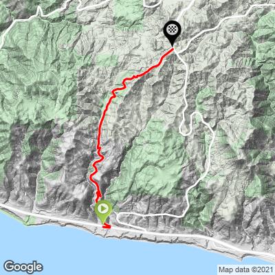
10
PDI
4 mi
DISTANCE
1,566 ft
GAINED
7.4 %
AVG. GRADE
FULL CLIMB STATS
INTRO
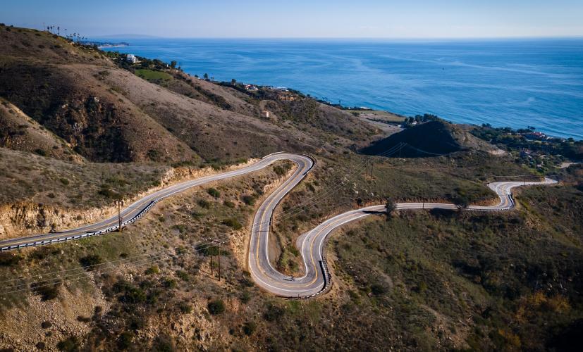
Without a doubt the best pair of hairpins in Southern California -- but a couple of the steepest too! Decker Road begins with a punchy section of 1.5 miles above 10%. Nonetheless, this is perhaps the most picturesque climb in Malibu, and definitely worth the trip to ride!
See also our Santa Monica Mountains Climb Area page - these mountains are one of the great winter cycling venues.
If you are planning a trip to this area, the best way to find climbs, navigate, share and locate trip participants is with PJAMM's Santa Monica Mountains Preloaded SMM Trip page, one of 100 preloaded cycling adventures available with the PJAMM Adventure App.
PLAN YOUR ROUTE
See more details and tools regarding this climb's grade via our interactive Profile Tool.
Roadway:
Road surface is excellentParking:
You can park anywhere along the Pacific Coast Hwy for free
Traffic:
Traffic is typically light, but can be moderate on weekends and late afternoons. This is a popular road for motorcycles and sports cars.
One of the only places to get water in Malibu is at the fire station right at the top of this climb.
Before heading out on any cycling adventure check out our Things to Bring on a Cycling Trip and use our interactive check list to ensure you don't forget anything.
Information Not Available
If you have any information regarding this climb, we'd like to hear from you. Click the CONTRIBUTE button to share your thoughts with us.
ROUTE MAP
MEMBER RATING
CURRENT WEATHER
PJAMM TRIPS ADVENTURE STARTER BUNDLES
Check out PJAMM Adventure's prepackaged (self-guided) cycling trips. They will help you plan, document and conquer your next adventure.
NEARBY CLIMBS (0) RADIAL PROXIMITY
FROM No Climbs Found
MEMBER REVIEWS & COMMENTS
Let us know what you thought of this climb. Signup for our FREE membership to write a review or post a comment.
Already have an account?
LOG IN HERE
joelmblatt
Some steep sections, but not much.
Tinypip
Decker, well, I never really am happy to be on this climb, but if you want a steep punch in the face, it's great for that. Way less busy than nearby Encinal, but feels way harder. Hits you pretty hard off the start, so it's easy to blow up early. Some of the only free water in the area is found at the fire station at the top. Has an outdoor spigot that is a necessity for most rides in the area. Old Place has unreliable water these days.